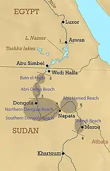
بطن الحجر
بطن الحجر أو بطن الحجارة يبلغ طولها حوالي 160 كيلومترًا وتمتد من شلال دال لنهر النيل إلى أسفل بحيرة النوبة المغمورة حاليًا في السودان .[1]

Physiographic zones corresponding to distinct Reaches in the Nile
تاريخ
بطن الحجر أرض قاحلة وغنية بالجرانيت تعد التربة الصالحة للزراعة ، وبالتالي فهي قليلة السكان. كانت بطن الحجر الحدود التقليدية بين النوبة العليا والنوبة السفلى . يوجد في هذا المجال عدد من المواقع الأثرية المهمة للمجموعة [2] والمروية.[3][4]
مراجع
- Geography of Nubia. نسخة محفوظة 2021-06-15 على موقع واي باك مشين.
- Kathryn A. Bard (ed.); Encyclopedia of the Archaeology of Ancient Egypt; Routledge 1999; pp.83-84.
- William Y. Adams; Dynasties and Empires. The Southward Course of Empire. Meroitic Civilization of the Steppelands; in: Nubia: corridor to Africa; Princeton University Press; 1977.
- D. N. Edwards and A. J. Mills; 'Pharaonic' Sites in the Batn el-Hajar - the 'Archaeological Survey of Sudanese Nubia' Revisited; in: Sudan & Nubia, No 17, published by The Sudan Archaeological Research Society; 2013.
- بوابة السودان
This article is issued from Wikipedia. The text is licensed under Creative Commons - Attribution - Sharealike. Additional terms may apply for the media files.