Ådalsbruk
Ådalsbruk is a village in Løten municipality in Innlandet county, Norway. The village is located along the river Svartelva, just east of the Norwegian National Road 3. The village of Løten lies about 4 kilometres (2.5 mi) north of Ådalsbruk and the village of Romedal lies about 6 kilometres (3.7 mi) to the south.
Ådalsbruk
Aadalsbruk | |
|---|---|
Village | |
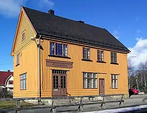 View of the Ådalsbruk Station | |
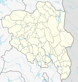 Ådalsbruk Location of the village  Ådalsbruk Ådalsbruk (Norway) | |
| Coordinates: 60.79653°N 11.30883°E | |
| Country | Norway |
| Region | Eastern Norway |
| County | Innlandet |
| District | Hedmarken |
| Municipality | Løten Municipality |
| Area | |
| • Total | 0.77 km2 (0.30 sq mi) |
| Elevation | 191 m (627 ft) |
| Population (2021)[1] | |
| • Total | 759 |
| • Density | 992/km2 (2,570/sq mi) |
| Time zone | UTC+01:00 (CET) |
| • Summer (DST) | UTC+02:00 (CEST) |
| Post Code | 2345 Ådalsbruk |
The 0.77-square-kilometre (190-acre) village has a population (2021) of 759 and a population density of 992 inhabitants per square kilometre (2,570/sq mi).[1]
Ådalsbruk is an old industrial site. The village name was taken from the iron works Aadals Brug Jernstøberi og Mek. Værksted which existed from 1842 to 1928. The paper mill Klevfos Cellulose- og Papirfabrik existed from 1888 to 1976, and now that is a museum.[3]
The village formerly had its own railway station, Ådalsbruk Station, which was a stop along the Røros Line.[4]
Notable people
- Edvard Munch, the painter, was born in Ådalsbruk in 1863.
References
- Statistisk sentralbyrå (1 January 2021). "Urban settlements. Population and area, by municipality".
- "Ådalsbruk, Løten". yr.no. Retrieved 27 March 2022.
- Mæhlum, Lars. "Ådalsbruk". Store Norske Leksikon (in Norwegian). Kunnskapsforlaget.
- "Ådalsbruk Station". Norsk Jernbaneklubb.