Úlfarsfell
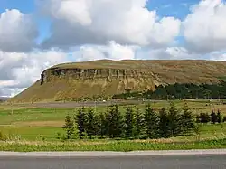
Úlfarsfell (Icelandic pronunciation: [ˈulvar̥sˌfɛtl̥]) is a mountain in the municipality of Mosfellsbær in the Reykjavík metropolitan area. It is 296 meters high. The mountain slopes have been subject to extensive forestry.[1]

Úlfarsfell

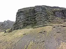
The iconic cliffs on the northwest side of Úlfarsfell.

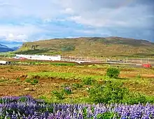
Úlfarsfell with nootka lupin in the foreground.
Úlfarsfell is mentioned in the written work Hítardalsbók from 1367 and in the land registry from 1704 by Árni Magnússon and Páll Vídalín. The name of the mountain, and the nearby river Úlfarsá, likely comes from a settler named Úlfar, which was born by at least four settlers according to Landnáma, the book of settlers.[2]
The mountain currently hosts television and radio transmitters for the Reykjavik area, after transmissions were moved from the former Vatnsendi site.[3]
References
- Úlfarsfell. From gonguleidir.is retrieved on April 11, 2021 (in Icelandic).
- Sigmundsson, S. (2013). Hvaðan dregur Úlfarsfell nafn sitt? Vísindavefurinn. Retrieved on April 11, 2021.
- Kristjánsson, Alexander (2021-08-23). "Þarf að snúa loftnetum að Úlfarsfelli - RÚV.is" [People need to turn their antennas towards Úlfarsfell]. RÚV (in Icelandic). Retrieved 2023-07-14.
This article is issued from Wikipedia. The text is licensed under Creative Commons - Attribution - Sharealike. Additional terms may apply for the media files.