Úslava
The Úslava is a river in the Czech Republic, a right tributary of the Berounka River. It flows through the Plzeň Region. It is 96.3 km (59.8 mi) long.
| Úslava | |
|---|---|
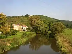 The Úslava in Starý Plzenec | |
| Location | |
| Country | Czech Republic |
| Region | Plzeň |
| Physical characteristics | |
| Source | |
| • location | Kolinec, Blatná Uplands |
| • elevation | 637 m (2,090 ft) |
| Mouth | |
• location | Berounka |
• coordinates | 49°45′46″N 13°24′47″E |
• elevation | 299 m (981 ft) |
| Length | 96.3 km (59.8 mi) |
| Basin size | 755.7 km2 (291.8 sq mi) |
| Discharge | |
| • average | 3.55 m3/s (125 cu ft/s) |
| Basin features | |
| Progression | Berounka→ Vltava→ Elbe→ North Sea |
Etymology
Until the early 18th century, the river was called Bradlava. The name first appeared in 1266 as Bradaua. In the following centuries, the name was also written as Radawa, Bradava, Brádava and Bradlavka. In 1712, Cistercian cartographer Mauritius Vogt confused Bradlava with Úhlava in his book, and also made a typographical error when he wrote it as Úslava. Since then, the name Úslava has been used.[1]
Characteristic
The Úslava originates in the territory of Kolinec in the Blatná Uplands at the elevation of 637 m (2,090 ft), on the slope of the Zálužnice mountain, and flows to Plzeň, where it enters the Berounka River at the elevation of 299 m (981 ft). It is 96.3 km (59.8 mi) long. Its drainage basin has an area of 755.7 km2 (291.8 sq mi).[2]
The tributaries of the Úslava do not include any significant rivers, only smaller streams. The longest tributaries of the Úslava are:
| Tributary | Length (km) | River km | Side |
|---|---|---|---|
| Bradava | 21.7 | 26.1 | right |
| Myslivský potok | 19.1 | 53.1 | right |
| Kornatický potok | 17.8 | 23.5 | right |
Settlements
The river flows through the municipal territories of Kolinec, Číhaň, Zavlekov, Hnačov, Plánice, Újezd u Plánice, Mlýnské Struhadlo, Neurazy, Žinkovy, Prádlo, Klášter, Vrčeň, Srby, Ždírec, Blovice, Zdemyslice, Žákava, Nezvěstice, Šťáhlavy, Starý Plzenec and Plzeň.
Bodies of water
There are 78 bodies of water larger than 1 ha in the basin area. The largest of them are the fishponds Kovčínský with an area of 99 ha (240 acres) and Myslivský with an area of 63 ha (160 acres).[2] Many fishponds were founded directly the Úslava; the largest of them are Hnačovský, Žinkovský and Labuť.
Tourism
For most of the year, the Úslava is not suitable for river tourism due to lack of water.[3]
See also
References
- "Jméno řece Úslavě vymyslel tiskařský šotek" (in Czech). Czech Radio. 2017-09-22. Retrieved 2023-10-03.
- "Základní charakteristiky toku Úslava a jeho povodí" (in Czech). T. G. Masaryk Water Research Institute. Retrieved 2023-10-03.
- "Úslava – nejmenší a zapomenutá Plzeňačka" (in Czech). Pádler. 2017-11-11. Retrieved 2023-10-03.
External links
- River flow at Koterov station – Flood Warning and Forecasting Service of the Czech Hydrometeorological Institute