Ħal Tmiem
Ħal Tmiem is a suburb of Żejtun, Malta. Located 1.13 kilometres (3,700 ft) east of the city center. It has an area of 0.11 square kilometres (27 acres)[1][2]
Ħal Tmiem
Hal Tmim Rahal Timin | |
|---|---|
Suburb | |
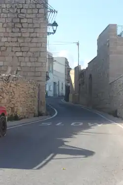 "Triq Wied iz-Ziju". The main road within Hal Tmiem | |
 | |
| Coordinates: 35°51′17″N 14°32′43″E | |
| Founded by | Leonardo Tabone |
| Named for | Temim Assant |
| Area | |
| • Total | 0.11 km2 (0.04 sq mi) |
| Elevation | 53 m (174 ft) |
Name
Unlike common belief that the town is named "Tmiem"1 due to it being on the outskirts of the much-larger town of Zejtun, the suburb's name is actually derived from "Temim Assant" which is the name of an Arabic individual who lived in the area. Its name then changed through the following:
- “raħal timin” (1498)
- “raħal timil” (1534)
- “raħal Chimin” (1538)
- “racal timin” (1538)
- “ta’ ħal timin” (1593)[3]
Chapel of St Mary of Ħal Tmin
This chapel was founded in 1597 by Leonardo Tabone and is dedicated to the Assumption of Mary. It remains active and is used to teach catechism classes and other religions actives and meetings.[2][4]
Notes
- 1"Tmiem" has the meaning of "End" in the Maltese Language.[5]
References
- Wettinger, Godfrey, 1929- (2000). Place-names of the Maltese Islands : ca. 1300-1800. San Gwann (Malta): PEG. ISBN 978-99909-92-49-6. OCLC 45215607.
{{cite book}}: CS1 maint: multiple names: authors list (link) - Abela, Joe (2006). Il-parrocca taz-Zejtun tul iz-zminijiet. Sta Venera: Klabb Kotba Maltin. ISBN 99932-7-081-4. OCLC 255003545.
- Noel Ciantar. "ZTN SM Hal Tmin". www.kappellimaltin.com. Retrieved 2020-10-18.
- "Environmental Report" (PDF). 2019-01-25. Archived (PDF) from the original on 2019-01-25. Retrieved 2020-10-18.
- "Tmiem in English with contextual examples - MyMemory". mymemory.translated.net. Retrieved 2020-10-18.
This article is issued from Wikipedia. The text is licensed under Creative Commons - Attribution - Sharealike. Additional terms may apply for the media files.