1997 Umbria and Marche earthquake
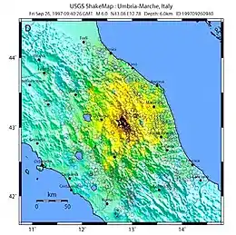
The 1997 Umbria and Marche earthquake occurred in the regions of Umbria and Marche, central Italy on the morning of 26 September. It was preceded by a foreshock almost as strong as the main quake. The foreshock occurred at 02:33 CEST (00:33 UTC), rated Mw5.7, and the second – the main shock – occurred at 11:40 CEST (09:40 UTC), rated Mw 6.0. Their epicentre was in Annifo. The mainshock was assigned X (Extreme) and foreshock VIII (Severe) on the Mercalli intensity scale.[2]
 | |
 | |
| UTC time | 1997-09-26 09:40:26 |
|---|---|
| ISC event | 1043512 |
| USGS-ANSS | ComCat |
| Local date | 26 September 1997 |
| Local time | 11:40 |
| Magnitude | 6.0 Mw |
| Depth | 10 km (6.2 mi) |
| Epicenter | 43.084°N 12.812°E |
| Areas affected | Italy (Umbria, Marche) |
| Max. intensity | X (Extreme)[1] |
| Casualties | 11 dead 100 injured |
There were several thousands of foreshocks and aftershocks from May 1997 to April 1998, more than thirty of which had a magnitude more than 3.5. Eleven people are known to have died following the shocks.
List of foreshocks and aftershocks
Only shocks (both foreshocks and aftershocks) with magnitude 5.0 or higher are listed.[3]
| Date (YYYY-MM-DD) | Time (UTC) | Latitude | Longitude | Depth | Magnitude |
|---|---|---|---|---|---|
| 1997-09-26 | 00:33:12 | 43.048° N | 12.879° E | 10 km (6 mi) | 5.7 (Mw ) |
| 1997-09-26 | 09:40:26 | 43.084° N | 12.812° E | 10 km (6 mi) | 6.0 (Mw ) |
| 1997-09-26 | 09:47:38 | 43.163° N | 12.752° E | 10 km (6 mi) | 4.7 (Mw ) |
| 1997-10-03 | 08:55:21 | 43.075° N | 12.794° E | 10 km (6 mi) | 5.3 (Mw ) |
| 1997-10-06 | 23:24:52 | 43.045° N | 12.835° E | 10 km (6 mi) | 5.5 (Mw ) |
| 1997-10-12 | 11:08:36 | 42.901° N | 12.897° E | 10 km (6 mi) | 5.3 (Mw ) |
| 1997-10-14 | 15:23:10 | 42.962° N | 12.892° E | 10 km (6 mi) | 5.6 (Mw ) |
| 1997-11-09 | 19:07:33 | 42.903° N | 12.948° E | 10 km (6 mi) | 5.0 (Mw ) |
| 1998-03-26 | 16:26:11 | 43.255° N | 12.969° E | 10 km (6 mi) | 5.4 (Mw ) |
| 1998-04-03 | 07:26:36 | 43.164° N | 12.701° E | 10 km (6 mi) | 5.2 (Mw ) |
| 1998-04-05 | 15:52:20 | 43.185° N | 12.719° E | 10 km (6 mi) | 5.0 (Mw ) |
Notes
- "M 6.0 – 3 km SSE of Nocera Umbra, Italy". earthquake.usgs.gov. USGS. Retrieved 3 July 2021.
- "M 5.7 – 6 km WSW of Serravalle di Chienti, Italy". earthquake.usgs.gov. USGS. Retrieved 3 July 2021.
- "NEIC: Earthquake Search Results". earthquakes.usgs.gov. 2009-10-01. Archived from the original on 2012-05-25. Retrieved 2009-10-01.
Further reading
- Amato, A.; Azzara, R.; Chiarabba, C.; Cimini, G. B.; Cocco, M.; Di Bona, M.; Margheriti, L.; Mazza, S.; Mele, F.; Selvaggi, G.; Basili, A.; Boschi, E.; Courboulex, F.; Deschamps, A.; Gaffet, S.; Bittarelli, G.; Chiaraluce, L.; Piccinini, D.; Ripepe, M. (1998), "The 1997 Umbria-Marche, Italy, Earthquake Sequence: A first look at the main shocks and aftershocks" (PDF), Geophysical Research Letters, 25 (15): 2861–2864, Bibcode:1998GeoRL..25.2861A, doi:10.1029/98GL51842, S2CID 140166678
- Cattaneo, M.; Augliera, P.; De Luca, G.; Gorini, A.; Govoni, A.; Marcucci, S.; Michelini, A.; Monachesi, G.; Spallarossa, D.; Trojani, L.; Xgums (2000), "The 1997 Umbria-Marche (Italy) earthquake sequence: Analysis of the data recorded by the local and temporary networks", Journal of Seismology, 4 (4): 401–414, Bibcode:2000JSeis...4..401C, doi:10.1023/A:1026511209166, S2CID 129453544
- Cinti, F. R. (2009), "The 1997-1998 Umbria-Marche post-earthquakes investigation: Perspective from a decade of analyses and debates on the surface fractures", Annals of Geophysics, 51 (2–3), CiteSeerX 10.1.1.611.4395, doi:10.4401/ag-4450
- Dolce, M.; Masi, A.; Goretti, A. (2018), "Damage to buildings due to 1997 Umbria-Marche earthquake", Seismic Damage to Masonry Buildings, pp. 71–80, doi:10.1201/9780203740040-6, ISBN 9780203740040, S2CID 135235868
- Ripepe, M.; Piccinini, D.; Chiaraluce, L. (2000), "Foreshock sequence of September 26th, 1997 Umbria-Marche earthquakes", Journal of Seismology, 4 (4): 387–399, Bibcode:2000JSeis...4..387R, doi:10.1023/A:1026508425230, S2CID 126729602
- Spence, Robin; d'Ayala, Dina (1999), "Damage Assessment and Analysis of the 1997 Umbria-Marche Earthquakes", Structural Engineering International, 9 (3): 229–233, doi:10.2749/101686699780482014
External links
- CFTI4med Archived 2011-07-22 at the Wayback Machine
- Earthquake Assisi, Italy – Terremoto Assisi, Italia 1997 – The only existing video footage of the quake, showing the moment it destroyed the Basilica of Saint Francis of Assisi.
- The International Seismological Centre has a bibliography and/or authoritative data for this event.