2011 El Reno–Piedmont tornado
The 2011 El Reno–Piedmont tornado was a long-tracked, deadly EF5 tornado that struck central Oklahoma on the evening of May 24, 2011. The tornado impacted areas near or within the communities of El Reno, Piedmont, and Guthrie, killing nine and injuring 181. After producing incredible damage in several locations along a path of over 60 mi (97 km), the El Reno–Piedmont tornado was given a rating of EF5, the highest category on the Enhanced Fujita scale, and was found by mobile radar to have possessed possible wind speeds of up to 295 mph (475 km/h). It was the first tornado rated EF5 or F5 to strike Oklahoma since the 1999 Bridge Creek–Moore tornado.
| |
| Meteorological history | |
|---|---|
| Date | May 24, 2011 |
| Formed | 3:51 p.m. CDT |
| Dissipated | 5:35 p.m. CDT |
| EF5 tornado | |
| on the Enhanced Fujita scale | |
| Highest winds |
|
| Overall effects | |
| Fatalities | 9 |
| Injuries | 181 |
| Areas affected | Canadian County, Kingfisher County, Logan County, Central Oklahoma, United States |
Part of the tornado outbreak sequence of May 21–26, 2011 | |
2011 was a prolific year for both tornadoes and tornado-associated fatalities, with multiple destructive outbreaks. The El Reno–Piedmont tornado occurred during a wider severe weather episode across Oklahoma and the Great Plains that produced multiple violent tornadoes near the Oklahoma City metropolitan area on May 24, and was itself part of a tornado outbreak sequence spanning May 21 to May 26, 2011. The Oklahoma storms came just two days after a devastating EF5 tornado in Joplin, Missouri on May 22, which killed 158 people and became the costliest tornado in U.S. history.
El Reno has infamously been the site of several other intense tornadoes. Just two years later, on May 31, 2013, another tornado just south of the town became the largest tornado ever recorded, with a width of 2.6 miles (4.2 km) and radar-indicated wind speeds well over 200 mph (320 km/h). The massive multiple-vortex tornado killed eight people, including three storm chasers, and received a damage rating of EF3.[1][2] In 2019, a brief tornado spawned from an intense squall line struck just southeast of El Reno, killing two people and injuring dozens while again receiving a rating of EF3.[3]
Meteorological synopsis
Setup
Early on May 24 a strong upper-level trough (an elongated region of low atmospheric pressure aloft) advanced towards the Great Plains out of the southwestern United States and took on a negative tilt, becoming oriented northwest to southeast.[4][5]: 504
At the same time, southerly flow brought moisture north over Texas and the southern Great Plains, allowing dew points in Central Oklahoma to reach 18–21 °C (64–70 °F).[5]: 504–505 This moisture, with temperatures in the mid 80 °F (27 °C) range, allowed for ample convective available potential energy (or CAPE, a measure of atmospheric instability); values reached 2500–4000 J/kg. Mid-level lapse rates were nearly dry adiabatic.[6]: 2 [5]: 504–505
In the late morning, a shortwave embedded within the main longwave trough advanced more rapidly, pushing the dryline into western Oklahoma, where it met the already-present moisture.[5]: 504–505 The shortwave's advance also brought strong wind shear and "incredibly high" storm-relative helicity values of more than 500 m2s−2. The convergence of all these factors promised the development of intense convective thunderstorms.[6]: 2
Forecast
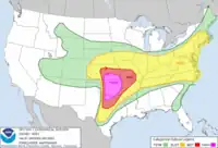
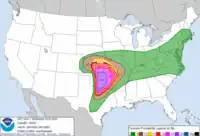
This risk was anticipated by the National Weather Service's Storm Prediction Center (SPC), and its local forecast office in Norman, Oklahoma. The Storm Prediction Center's outlooks for severe weather culminated in a "high risk" area being delineated over the Great Plains for May 24. Issued at 11:25 a.m. CDT, the Storm Prediction Center's convective outlook for the day highlighted the tornado risk, which included central Oklahoma inside a large region of a 45% chance of a tornado touchdown within 25 miles (40 km) of any given point, and a 10% or greater chance of a significant (EF2+) tornado within that same 25 miles (40 km) radius.[7]
...AN INTENSE OUTBREAK OF TORNADOES AND WIDESPREAD SEVERE THUNDERSTORMS IS EXPECTED LATER TODAY OVER PORTIONS OF KS/OK/TX...
...WITH ALL CONDITIONS FAVORING THE POTENTIAL FOR LONG-TRACKED STRONG/VIOLENT TORNADOES AND VERY LARGE HAIL OVER PORTIONS OF NORTH TX...CENTRAL OK...AND CENTRAL KS.
— NWS Storm Prediction Center (SPC), May 24, 2011 1630 UTC Day 1 Convective Outlook
At 12:50 p.m., the Storm Prediction Center issued a Particularly Dangerous Situation (PDS) tornado watch, to remain in effect until 10:00 p.m., for most of central Oklahoma extending from the state border with Kansas down through the Oklahoma City metropolitan area and into northern Texas. The text of the tornado watch again warned of the possible development of "destructive tornadoes... …some of which could be long-tracked and strong to violent."[8]
Initiation
Thunderstorms began to develop before 2:00 p.m. in a north–south oriented line just east of the dryline where the capping inversion was weakest,[5]: 505 including near Altus and Lawton in southwest Oklahoma. The tightly spaced storm cells rapidly developed classic supercell characteristics as they moved northeast.[4] The storm that produced the El Reno–Piedmont EF5 tornado formed approximately 93 miles (150 km) west-southwest of Oklahoma City.[5]: 505
Storm track and damage
The supercell that eventually generated the El Reno–Piedmont tornado first produced a tornado in Caddo County, Oklahoma, which tracked from west of the town of Lookeba to just northeast of it. The Lookeba tornado developed at 3:31 p.m. and persisted for approximately 16 minutes, traveling nine miles (14 km) and destroying multiple structures. The 800-yard (730 m)-wide tornado earned a damage rating of EF3.[4] As the Lookeba tornado moved northeast towards the Caddo/Canadian county border, between 3:40 and 3:42 p.m. the supercell's mesocyclone broadened and weakened slightly; this was followed by the development of a second mesocyclone from the original to the east-southeast between 3:42 and 3:44 p.m.[9]: 2689 This marked the start of the decay of the Lookeba tornado, which fully dissipated by 3:47 p.m.[9]: 2690 Over the next several minutes the original western mesocyclone dwindled as the newer mesocyclone coalesced, and the radar detection of a bounded weak echo region within the storm indicated that its updraft intensified during this period.[9]: 2691–2692
Hinton–Interstate 40
The El Reno–Piedmont tornado formed at 3:51 p.m., as determined by mobile radar data.[9] Over the next four minutes, the tornado's condensation funnel extending from a low-hanging wall cloud broadened, causing the tornado to take on a large 'wedge' appearance.[9]: 2696 It intensified quickly as it moved northeast, debarking and destroying many trees.[4] During this period, the storm was being monitored by a truck-mounted Rapid-Scan X-band Polarimetric (RaXPol) mobile Doppler weather radar, operated by the University of Oklahoma's Advanced Radar Research Center (ARRC) led by Howard Bluestein. That radar, stationed near the intersection of Smith Road and Walbaum Road less than two miles (3.2 km) south of I-40, captured the "first polarimetric, rapid-scan, mobile Doppler weather radar dataset of an EF-5 tornado."[10]: 3
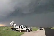
As the tornado moved towards I-40 to the southeast of the RaXPol radar, it detected some of the fastest wind speeds ever measured on the planet. Interpretations slightly differ: the maximum instantaneous radial velocity sampled by the radar was originally reported as having been 124.8 m/s (279 mph), measured 200–230 feet (60–70 m) above the ground at 4:00:26 p.m.;[11]: 4103 [10]: 3 [12]: 2 however, the maximum velocity was later reported as having been 132.1 m/s (295 mph) measured ~72 feet (22 m) "above radar level" at 4:00:39 p.m. in a 2014 paper by Bluestein et al on the use of radar data for tornado ratings.[1]: 811 Maximum radial velocities were also reported to have remained "greater than 120.0 m/s (268 mph) for several minutes."[12]: 2 Additionally, multiple consecutive radar scans were averaged to yield an estimated 2-second average radial velocity of 118.4 m/s (265 mph) and an estimated 4-second average velocity of 110.8 m/s (248 mph). This was reported as "likely to be an underestimate of the true 2- and 4-s average wind speeds."[1]: 3b
The instantaneous velocity readings taken are not directly equivalent to the three-second gust at 33 feet (10 m) that the Enhanced Fujita scale attempts to estimate, but they mark the second-highest wind speed ever recorded in a tornado, after wind speeds of approximately 135 m/s (300 mph) were recorded in both the 1999 Bridge Creek–Moore tornado[10] and a sub-vortex within the 2013 El Reno tornado.[1][2] Where the most intense winds are generally present in a tornado is an unresolved question, but the limited existing research suggests that wind speeds are likely to be highest closer to the ground.[13][1]: 804 After the detection of the wind speeds, the quality of the data degraded until collection ceased altogether at 4:16 p.m., as the tornado progressed to the northeast and towards I-40 where it would produce its most intense damage.[11]: 4103
Interstate 40–El Reno
When the tornado crossed I-40, the RaXPol radar 6.2 miles (10 km) away was still recording maximum radial velocities over 100 m/s (220 mph), 190 yards (170 m) above the ground.[12]: 2 There, the tornado struck multiple people in their cars. Three people—Terry Peoples, 50; Don Wesley Krug, 71; and Joan Krug, 67[14]—were killed in two separate full-size pickup trucks,[14] which were hurled thousands of feet from the road.[15] Their bodies were found more than 300 yards (270 m) north of the interstate, outside their vehicles, stripped of clothing, and rendered "unrecognizable," according to responding state troopers.[16] Several others were injured here as their vehicles were battered and overturned,[17] including a truck driver whose semi truck was flipped. The interstate was left littered with pieces of cars.[18] Two more fatalities in cars occurred just northeast of the interstate.[15]
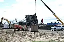
According to the National Weather Service, the tornado is believed to have peaked in intensity just after crossing I-40.[15] There, the tornado struck the Cactus 117 oil drilling rig site at EF5 intensity, completely destroying it. When it hit, the rig's pipes and drill head were inserted deep in the well's borehole, which provided the drilling pipe with 200,000 lb (91,000 kg) of downforce.[6]: 6 Despite this, and despite the fact that the drilling rig weighed 862 metric tons—or almost two million pounds—the rig was toppled onto its side and rolled several times. The well's blowout preventer was left bent at a 30 degree angle to the north. Elsewhere on the site, vehicles and cargo containers were lofted into the air and tossed.[12]: 2 [6]: 6
Twelve workers were on the site when the tornado struck, and took shelter in the site's change house (a steel container serving as a locker room). Tied down by four steel cables anchored 5.5 feet (1.7 m) deep in the ground, the container was pummeled with debris. One cable broke and the container was dented, but all twelve workers survived without serious injury.[12]: 2 [6]: 6 The move to tie down change houses for tornado shelters at Cactus drilling rigs had come less than a year before the El Reno–Piedmont tornado, and following the storm Cactus moved to reinforce the change house roofs and position them where the rig would be less likely to topple on to them.[19] Damage at the Cactus 117 rig amounted to $14 million.[20]
...A TORNADO WARNING REMAINS IN EFFECT UNTIL 445 PM CDT FOR NORTHEASTERN CANADIAN COUNTY...
AT 431 PM CDT...A LARGE...VIOLENT TORNADO WAS LOCATED IN THE NORTHERN PARTS OF EL RENO...MOVING EAST-NORTHEAST AT 30 MPH. PERSONS IN EL RENO...PIEDMONT...AND NORTHERN YUKON NEED TO BE TAKING SHELTER! THIS IS A VERY DANGEROUS SITUATION!
LOCATIONS IN THE WARNING INCLUDE CONCHO...EL RENO...NORTHWESTERN OKLAHOMA CITY...OKARCHE...PIEDMONT AND RICHLAND.
$
National Weather Service Norman, Oklahoma, Severe Weather Statement, 4:32 p.m. CDT, May 24 2011
After destroying the Cactus rig, the tornado continued moving northeast. Just to the west of the rig, it struck a complex of buildings (including a scrap yard, auto repair shop, garage, and grain storage facility). The repair shop, the garage, and a farmhouse were destroyed and the grain facility "damaged beyond repair."[6]: 7 Flying debris from the salvage yard impacted a new natural gas processing plant operated by Devon Energy, but all employees present avoided injury by sheltering on-site in time.[21] The damage caused a major gas leak at the plant, which was not secured until nightfall.[22] The tornado then passed between Fort Reno and an Oklahoma Mesonet site, which recorded a sharp drop in atmospheric pressure, as well as a one-minute average wind speed of 115 mph (185 km/h) and a maximum wind gust of 151 mph (243 km/h) at 4:21 p.m.[23][4] The gust was the highest wind speed ever recorded by the Oklahoma Mesonet.[23] The site sustained only minor damage, the tornado likely having passed several hundred yards from it.[24] Fort Reno sustained some structural damage.[22]
El Reno–Piedmont
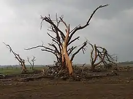
Leaving the environs of El Reno, the tornado then tracked through miles of mainly agricultural land. Widespread EF3 damage, pockmarked with areas of EF4 damage, was found between the towns of El Reno and Piedmont.[15]
During the tornado's journey between El Reno and Piedmont, at least two satellite tornadoes were present at different times. The first was only recognized after-the-fact using radar data. That data shows the El Reno–Piedmont tornado and a separate cyclonic tornado, originating from the same mesocyclone, rotating in a counterclockwise fashion about a single common center (in a demonstration of the Fujiwhara effect) for several minutes, before merging at approximately 4:35 p.m.[25]: 3033 The second satellite came just minutes later. At 4:37 p.m., a Storm Prediction Center employee observed this separate vortex several miles northwest of Richland as it rotated around the main tornado for two minutes—only 50 yards (46 m) wide or so, it produced no damage that could be distinguished from that of the larger tornado, and was thus assigned a damage rating of EF0.[4]
Piedmont–Guthrie
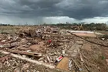
As the tornado neared Piedmont, it produced widespread EF4 damage north and west of the town.[26] About three point one miles (5 km) north of Piedmont, the tornado leveled ten homes on Northridge Lane and rolled or lofted vehicles into nearby fields. However, surveys found that nails had been used to help fasten the walls to their concrete slab foundations, which failed and left broken portions of the slabs where they had been driven in to them. The tornado destroyed two more houses on Axeman Street, 4.0 miles (6.5 km) northeast of Piedmont. A Chevrolet Avalanche parked in the garage of one of the residences was hurled 710 yards (650 m) to the northeast and into a thicket of trees in a ravine, which were debarked and relieved of their branches. The Chevrolet's engine block and axles were found nearby, ripped from the car. The damage here was assigned an EF4 rating.[12]: 2–3 In the subdivision of Falcon Lake, five miles (eight km) northeast of Piedmont and on the border of Canadian and Kingfisher counties, multiple homes again had the walls removed from their concrete slab foundations. Vehicles were tossed into an adjacent lake. Two children (aged 1 and 3) were killed in their home, which lacked a storm shelter.[26][12]: 4 All told, the tornado destroyed 88 homes in the Piedmont area.[27]
The tornado's intensity diminished somewhat as the tornado crossed into Kingfisher and Logan counties,[12]: 5 having already traveled just shy of 40 miles (64 km) on its track through Canadian County.[26] EF2 and EF3 damage still occurred as the tornado damaged houses, destroyed multiple mobile homes,[12]: 5 and collapsed high-voltage transmission towers, while continuing to debark trees to the point where only stumps remained.[28] The tornado killed two more people—caught outside without shelter—near the community of Cashion.[12]: 5 Along SH-74, the tornado destroyed three homes and an airplane hangar.[18] The tornado approached Guthrie, but moved northwest of the town, which avoided a direct hit. The tornado finally dissipated northeast of Guthrie, producing only minor tree damage there.[29]
The tornado's parent supercell went on to produce another tornado south of the community of Stillwater, which earned a damage rating of EF2.[4]
Summary
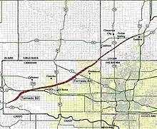
The tornado reached a maximum width of 1,760 yards (1,610 m), or over a mile wide at its peak. Its damage path was 63 miles (101 km) long. The tornado traversed this distance over the course of about 1 hour and 44 minutes, implying an average forward speed of approximately 36 miles per hour (58 km/h).[4] On June 1, 2011, National Weather Service officials upgraded the tornado's preliminary EF4 rating to EF5 based on a combination of the damage to the Cactus 117 drilling rig site, the complete destruction of other buildings in the rig's vicinity, tossed vehicles, and the mobile Doppler radar data.[6]: 7
In the end, 22 tornadoes occurred in central Oklahoma during the El Reno–Piedmont tornado's parent outbreak . In the Oklahoma City area, five main supercells produced 12 tornadoes,[6]: 1 three of them violent (EF4+). The El Reno–Piedmont tornado was the strongest of them all.[12]: 1 The El Reno–Piedmont tornado became one of only 59 tornadoes ever rated F5 or EF5 to date, and one of only nine tornadoes to receive an EF5 rating since the advent of the Enhanced Fujita scale in 2007. It was the first tornado in Oklahoma to receive an EF5 rating, and the only one until the 2013 Moore tornado.[15]
Impacts
Following the tornado, first responders in Canadian County scoured the 10–20-square-mile (26–52 km2) debris path in the corridor west of El Reno near the interstate. Three emergency operations centers were established in Canadian County near Piedmont, El Reno, and Interstate 40.[22]
Casualties
The El Reno–Piedmont tornado killed nine people and injured 181,[4] making it responsible for the majority of the casualties caused by the entire outbreak (in which 11 died and 293 were injured).[6]: 2 Of that total, seven deaths and 112 injuries occurred in Canadian County,[26] 46 injuries occurred in Kingfisher County,[29] and two deaths and 23 injuries occurred in Logan County.[28] Three children with critical injuries in Piedmont numbered among the casualties in Canadian County.[18]
In an overview of the outbreak in a paper presented at the annual American Meteorological Society conference, National Weather Service authors speculated that the relatively low number of fatalities during the outbreak (which involved three violent tornadoes near a major metropolitan area) was due in part due to "the incredible reaction of the community to not only watches and warnings, but also to the forecast of severe weather" on May 24.[6]: 2
Damage
The Devon Energy natural gas plant near El Reno was forced offline for several weeks as the company assessed and repaired the $140 million facility.[21]
Though the amount of $14 million was given as the cost of damage to the Cactus 117 drilling rig site in news reports, a detailed monetary damage estimate by NWS/NOAA for the El Reno–Piedmont tornado was not made available.[4] The only government assessment of damages appears in the tornado's entry in NOAA's NCEI Storm Events Database, which predicted that the total was "probably going to be well in the tens of millions."[26] Meanwhile, insurance officials reported an estimated $200–300 million in total private property insured losses from the Oklahoma portion of the tornado outbreak.[30]
The city of Piedmont paid $230,380 for debris removal, 75% of which was reimbursed by FEMA.[31]
Political response
Governor of Oklahoma Mary Fallin declared a state of emergency in 68 counties on May 24, including Canadian, Kingfisher, and Logan counties, before taking to the air to survey damage in a number of areas, which included Piedmont and Guthrie.[32] On May 29, Governor Fallin requested that the White House issue a federal major disaster declaration for seven Oklahoma counties, again including Canadian, Kingfisher, and Logan counties.[33] On June 6, President Obama approved Governor Fallin's request for federal disaster relief.[34]
In September 2011, Governor Fallin and state emergency management officials announced the SoonerSafe-Safe Room Rebate Program, using $1 million in FEMA funds, which distributed cash rebates via a statewide drawing to reimburse up to 500 Oklahomans seeking to build storm shelters. Victims of the May 24 tornado outbreak were among those who received priority selection for the rebates.[35]
See also
References
- Snyder, Jeffrey C.; Bluestein, Howard B. (August 1, 2014). "Some Considerations for the Use of High-Resolution Mobile Radar Data in Tornado Intensity Determination". Weather and Forecasting. 29 (4): 799–827. doi:10.1175/WAF-D-14-00026.1. ISSN 1520-0434.
- Bluestein, Howard B.; Thiem, Kyle J.; Snyder, Jeffrey C.; Houser, Jana B. (August 1, 2018). "The Multiple-Vortex Structure of the El Reno, Oklahoma, Tornado on 31 May 2013". Monthly Weather Review. 146 (8): 2483–2502. doi:10.1175/MWR-D-18-0073.1. ISSN 1520-0493.
- Fernandez, Manny; Fenwick, Ben (May 26, 2019). "'There I Was, Flying Across the Room': Tornado Leaves an Oklahoma Town Shaken". The New York Times. ISSN 0362-4331. Retrieved March 2, 2023.
- "The May 24, 2011 Tornado Outbreak in Oklahoma". National Weather Service. NOAA. Archived from the original on December 11, 2022. Retrieved February 9, 2022.
- Tanamachi, Robin L.; Heinselman, Pamela L.; Wicker, Louis J. (June 1, 2015). "Impacts of a Storm Merger on the 24 May 2011 El Reno, Oklahoma, Tornadic Supercell". Weather and Forecasting. 30 (3): 501–524. doi:10.1175/WAF-D-14-00164.1. ISSN 1520-0434.
- Ortega, Kiel L.; Bluestein, Howard B.; Burgess, Donald W.; et al. (January 25, 2012). Overview of the May 24 2011 Tornado Outbreak. 92nd American Meteorological Society Annual Meeting, Special Symposium on the Tornado Disasters of 2011. Archived from the original on February 7, 2023. Retrieved February 10, 2023 – via American Meteorological Society.
- Hart, John A.; Grams, Jeremy S. (May 24, 2011). Storm Prediction Center May 24, 2011 1630 UTC Day 1 Convective Outlook (Report). Norman, Oklahoma: NOAA/NWS Storm Prediction Center (SPC). Archived from the original on January 10, 2019. Retrieved February 13, 2023.
- Mead, Corey M. (May 24, 2011). Particularly Dangerous Situation (PDS) Tornado Watch 356. Storm Prediction Center (Report). Norman, Oklahoma: National Oceanic and Atmospheric Administration. Archived from the original on September 3, 2014. Retrieved May 24, 2011.
- Houser, Jana Lesak; Bluestein, Howard B.; Snyder, Jeffrey C. (July 1, 2015). "Rapid-Scan, Polarimetric, Doppler Radar Observations of Tornadogenesis and Tornado Dissipation in a Tornadic Supercell: The "El Reno, Oklahoma" Storm of 24 May 2011". Monthly Weather Review. 143 (7): 2685–2710. doi:10.1175/MWR-D-14-00253.1. ISSN 1520-0493.
- Bluestein, Howard B.; Snyder, Jeffrey C.; Houser, Jana B.; Pazmany, Andrew L. (June 28, 2012). Rapidscan, polarimetric, mobile Doppler radar observations at Xband of an EF5 tornado in Oklahoma on 24 May 2011 (PDF). The Seventh European Conference on Radar in Meteorology and Hydrology. Archived from the original (PDF) on March 1, 2022 – via Météo France.
- Houser, Jana Lesak; Bluestein, Howard B.; Snyder, Jeffrey C. (November 1, 2016). "A Finescale Radar Examination of the Tornadic Debris Signature and Weak-Echo Reflectivity Band Associated with a Large, Violent Tornado". Monthly Weather Review. 144 (11): 4101–4130. doi:10.1175/MWR-D-15-0408.1. ISSN 1520-0493.
- Marshall, Timothy P. (Haag Engineering Co.); Ladue, James G.; Ortega, Kiel L.; Stumpf, Gregory J. (NOAA/NWS) (November 7, 2012). Performance of residences and shelters in the Oklahoma tornadoes of 24 May 2011. 26th Conference on Severe Local Storms. Archived from the original on February 10, 2023. Retrieved February 10, 2023 – via American Meteorological Society.
- Kosiba, Karen; Wurman, Joshua (February 24, 2023). "The strongest winds in tornadoes are very near the ground". Communications Earth & Environment. 4 (1): 1–6. doi:10.1038/s43247-023-00716-6. ISSN 2662-4435.
- Ellis, Randy (May 29, 2011). "Fulfilling deadly predictions". The Oklahoman. pp. 16A (archive), 17A. Archived from the original on February 21, 2023. Retrieved February 20, 2023 – via Newspapers.com.
- "Violent Tornadoes (F4/F5/EF-4/EF-5) in Oklahoma (1950–Present)". National Weather Service Norman, Oklahoma. NOAA. February 24, 2011. Archived from the original on September 18, 2020. Retrieved February 23, 2023.
- "Bodies found near I-40, bringing death toll to 9". Muskogee Phoenix. Associated Press. May 25, 2011. Archived from the original on February 9, 2023. Retrieved February 10, 2023.
- O’Connor, Anahad (May 25, 2011). "At Least 14 People Are Killed in Storms in 3 States". The New York Times. ISSN 0362-4331. Retrieved February 9, 2023.
- Dean, Bryan (May 25, 2011). "Twisters' deadly fury: At least 5 dead, dozens injured after tornadoes sweep across state". The Oklahoman. pp. 1A (archive), 4A. Archived from the original on February 19, 2023. Retrieved February 19, 2023 – via Newspapers.com.
- Wilmoth, Adam (May 30, 2014). "Reinforced shelters make oil patch safer in tornado season". The Oklahoman. Archived from the original on February 10, 2023. Retrieved February 10, 2023.
- Scott, Katherine (February 14, 2012). "12 lives saved in F5 tornado proves value of Cactus Drilling emergency plan". Drilling Contractor. Archived from the original on August 8, 2022. Retrieved February 10, 2023.
- Marks, Jay F. (May 26, 2011). "Oklahoma tornadoes: Devon Energy plant idled by damage". The Oklahoman. Archived from the original on May 27, 2022. Retrieved February 14, 2023.
- "El Reno Responds to Tornado Aftermath". KWTV-DT. May 25, 2011. Retrieved February 26, 2023.
- McManus, Gary. "Oklahoma Mesonet Site Records Tornadic Winds". Mesonet.org. Archived from the original on February 9, 2023. Retrieved February 9, 2023.
- Fiebrich, Chris (May 28, 2011). "Oklahoma Mesonet Station Stands Tall in EF-4 Tornado". The Front Page. American Meteorological Society. Archived from the original on February 13, 2023. Retrieved February 13, 2023.
- French, Michael M.; Skinner, Patrick S.; Wicker, Louis J.; Bluestein, Howard B. (August 1, 2015). "Documenting a Rare Tornado Merger Observed in the 24 May 2011 El Reno–Piedmont, Oklahoma, Supercell". Monthly Weather Review. 143 (8): 3025–3043. doi:10.1175/MWR-D-14-00349.1. ISSN 1520-0493.
- "Storm Events Database: Segment #1 of the Calumet-El Reno-Piedmont-Guthrie tornado". National Centers for Environmental Information. NOAA. Archived from the original on January 29, 2023. Retrieved March 1, 2023.
- Medley, Robert (May 19, 2021). "A day of horror from the sky". Piedmont-Surrey Gazette. Archived from the original on May 20, 2021. Retrieved February 14, 2023.
- "Storm Events Database: Segment #3 of the Calumet-El Reno-Piedmont-Guthrie tornado". National Centers for Environmental Information. NOAA. Archived from the original on January 29, 2023. Retrieved March 1, 2023.
- "Storm Events Database: Segment #2 of Calumet-El Reno-Piedmont-Guthrie tornado". National Centers for Environmental Information. NOAA. Archived from the original on January 29, 2023. Retrieved March 1, 2023.
- Goodwin, Brandon; Kelley, Ann (June 8, 2011). "Oklahoma tornado damage slamming cities' budgets". The Oklahoman. Archived from the original on February 14, 2023. Retrieved February 14, 2023.
- Felder, Ben (January 19, 2012). "FEMA reimbursement on its way, more recovery money headed to Oklahoma". Piedmont Today. Piedmont-Surrey Gazette. Archived from the original on January 21, 2012. Retrieved March 7, 2023.
- "Governor Mary Fallin to tour Oklahoma tornado damage". News On 6. May 24, 2011. Archived from the original on February 13, 2023. Retrieved February 13, 2023.
- "Governor Fallin Requests Federal Disaster Assistance for Individuals, Businesses in 7 Counties". OK.gov. May 29, 2011. Archived from the original on February 13, 2023. Retrieved February 14, 2023.
- "White House approves Governor Fallin's request for tornado assistance". OK.gov. June 6, 2011. Archived from the original on February 13, 2023. Retrieved February 14, 2023.
- McNutt, Michael (September 28, 2011). "Oklahoma announces safe room rebate program". The Oklahoman. Archived from the original on March 7, 2023. Retrieved March 7, 2023.
External links
- National Weather Service, Norman, OK - The May 24, 2011 Tornado Outbreak in Oklahoma
- NOAA Damage Assessment Toolkit
35.444°N 98.287°W
(Starting location)

