27th meridian west from Washington
The 27th meridian west from Washington is an archaic meridian based on the Washington Meridian. The meridian is approximately 104 degrees west of the Prime Meridian.[1] It is used as the boundary of five states.
History
In May 1989, after the completion of the Transcontinental railroad, Oliver N. Chaffee, a surveyor and astronomer from Detroit, was hired by Robert R. Livingston, the Iowa and Nebraska Surveyor General, to survey the 25th and 27th meridians west of Washington D.C. Chaffee traveled to the eastern terminus of the Union Pacific Railroad at Omaha, where he met with the newly established astronomical station built by the U.S. Coast Survey. From there, he went to Bushnell, where he took astronomical readings for two days to coordinate with Omaha. Chaffee then placed a second astronomical station in Julesburg, and traveled east to connect the 25th and 27th meridians with the 41st Parallel, which formed the boundaries or corners of five western states.[2]
Usage as boundary
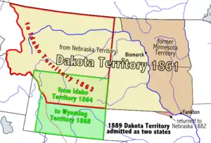
The usage of the meridian as a boundary began in 1863 when the Idaho Territory was created, with the 27th meridian as its eastern boundary.[3] At that time, the Dakota Territory and the Nebraska Territory gained their western boundary as portions of those territories were made a part of Idaho Territory. Nebraska became a state in 1867.[4] In 1868, the Wyoming Territory was created with the meridian as its eastern boundary.[5] The Dakota Territory was divided into North and South Dakota on November 2, 1889, and Montana became a state just six days later.[6][7] Wyoming became a state in 1890.[8]
In the present day, the Montana-North Dakota, Montana-South Dakota, Wyoming-South Dakota, and Wyoming-Nebraska state borders are all defined by the 27th meridian west from Washington.[9]
References
- Stein, Mark (2008). How the States Got Their Shapes. New York: Smithsonian Books. p. 172. ISBN 978-0-06-143138-8.
- Penry, Jerry (August 31, 2018). "West from Washington". The American Surveyor. Retrieved May 12, 2023.
- 12 Stat. 808
- "Citizens of the 37th State". We the People. Nebraska State Historical Society. January 4, 2013. Archived from the original on May 17, 2014. Retrieved May 15, 2014.
{{cite web}}: CS1 maint: unfit URL (link) - 15 Stat. 178
- Helm, Merry (November 2, 2003). "Statehood". Dakota Datebook. Prairie Public Broadcasting. Archived from the original on May 17, 2014. Retrieved May 15, 2014.
- Holmes, Krys (2008). "Chapter 10 - Politics and the Copper Kings, 1889 - 1904". Montana: Stories of the Land (PDF). Helena: Montana Historical Society Press. p. 193.
- "Wyoming History". State of Wyoming. 2013. Retrieved May 15, 2014.
- "Washington Meridian". US Ends .com. Retrieved May 12, 2023.