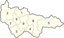
Administrative divisions of Khanty-Mansi Autonomous Okrug
| Khanty-Mansi Autonomous Okrug, Russia | |
|---|---|
| Administrative center: Khanty-Mansiysk | |
| As of 2013:[1] | |
| # of districts (районы) | 9 |
| # of cities/towns (города) | 16 |
| # of urban-type settlements (посёлки городского типа) | 24 |
| As of 2002:[2] | |
| # of rural localities (сельские населённые пункты) | 173 |
| # of uninhabited rural localities (сельские населённые пункты без населения) | 4 |

Map of Khanty-Manson Autonomous Okrug (with numbered)
Administrative and municipal divisions
| Division | Structure | OKATO | OKTMO | Urban-type settlement/ district-level town* | ||
|---|---|---|---|---|---|---|
| Administrative | Municipal | |||||
| Khanty-Mansiysk (Ханты-Мансийск) | city | urban okrug | 71 131 | 71 871 | ||
| Langepas (Лангепас) | city | urban okrug | 71 132 | 71 872 | ||
| Megion (Мегион) | city | urban okrug | 71 133 | 71 873 |
| |
| Nefteyugansk (Нефтеюганск) | city | urban okrug | 71 134 | 71 874 | ||
| Nizhnevartovsk (Нижневартовск) | city | urban okrug | 71 135 | 71 877 | ||
| Surgut (Сургут) | city | urban okrug | 71 136 | 71 876 | ||
| Raduzhny (Радужный) | city | urban okrug | 71 137 | 71 877 | ||
| Uray (Урай) | city | urban okrug | 71 138 | 71 878 | ||
| Nyagan (Нягань) | city | urban okrug | 71 139 | 71 879 | ||
| Beloyarsky (Белоярский) | city | (under Beloyarsky | 71 181 | 71 811 | ||
| Kogalym (Когалым) | city | urban okrug | 71 183 | 71 883 | ||
| Pokachi (Покачи) | city | urban okrug | 71 184 | 71 884 | ||
| Pyt-Yakh (Пыть-Ях) | city | urban okrug | 71 185 | 71 885 | ||
| Yugorsk (Югорск) | city | urban okrug | 71 187 | 71 887 | ||
| Beloyarsky (Белоярский) | district | 71 111 | 71 811 | |||
| Beryozovsky (Берёзовский) | district | 71 112 | 71 812 | |||
| Kondinsky (Кондинский) | district | 71 116 | 71 816 |
| ||
| Nefteyugansky (Нефтеюганский) | district | 71 118 | 71 818 |
| ||
| Nizhnevartovsky (Нижневартовский) | district | 71 119 | 71 819 |
| ||
| Oktyabrsky (Октябрьский) | district | 71 121 | 71 821 |
| ||
| Sovetsky (Советский) | district | 71 124 | 71 824 |
| ||
| Surgutsky (Сургутский) | district | 71 126 | 71 826 |
| ||
| Khanty-Mansiysky (Ханты-Мансийский) | district | 71 129 | 71 829 | |||
References
- Государственный комитет Российской Федерации по статистике. Комитет Российской Федерации по стандартизации, метрологии и сертификации. №ОК 019-95 1 января 1997 г. «Общероссийский классификатор объектов административно-территориального деления. Код 71 100», в ред. изменения №278/2015 от 1 января 2016 г.. (State Statistics Committee of the Russian Federation. Committee of the Russian Federation on Standardization, Metrology, and Certification. #OK 019-95 January 1, 1997 Russian Classification of Objects of Administrative Division (OKATO). Code 71 100, as amended by the Amendment #278/2015 of January 1, 2016. ).
- Results of the 2002 Russian Population Census—Territory, number of districts, inhabited localities, and rural administrations of the Russian Federation by federal subject Archived September 28, 2011, at the Wayback Machine
This article is issued from Wikipedia. The text is licensed under Creative Commons - Attribution - Sharealike. Additional terms may apply for the media files.
.svg.png.webp)