Afton, Wyoming
Afton is a town in Lincoln County, Wyoming, United States. The population was 2,172 at the 2020 census.
Afton, Wyoming | |
|---|---|
 Main Street Afton with antler arch | |
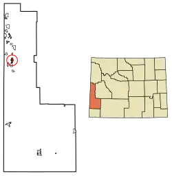 Location of Afton in Lincoln County, Wyoming. | |
 Afton, Wyoming Location in Wyoming  Afton, Wyoming Afton, Wyoming (the United States)  Afton, Wyoming Afton, Wyoming (North America) | |
| Coordinates: 42°43′42″N 110°55′45″W | |
| Country | United States |
| State | Wyoming |
| County | Lincoln |
| Area | |
| • Total | 4.45 sq mi (11.51 km2) |
| • Land | 4.44 sq mi (11.50 km2) |
| • Water | 0.01 sq mi (0.02 km2) |
| Elevation | 6,240 ft (1,902 m) |
| Population (2020) | |
| • Total | 2,172 |
| • Density | 459.79/sq mi (177.53/km2) |
| Time zone | UTC-7 (Mountain (MST)) |
| • Summer (DST) | UTC-6 (MDT) |
| ZIP code | 83110 |
| Area code | 307 |
| FIPS code | 56-00245[2] |
| GNIS feature ID | 1597691[3] |
| Website | www |
Afton is home to the world's largest arch made of elk antlers. Spanning 75 feet (23 m) across the four lanes of U.S. Highway 89, the arch consists of 3,011 elk antlers and weighs 15 tons.
History
The first settlement at Afton was made in 1885.[4] The community takes its name from the River Afton, in Ayrshire, Scotland.[4]
Geography
According to the United States Census Bureau, the town has a total area of 4.18 square miles (10.83 km2), all land.[5]
A periodic spring is Afton's main water supply, which cycles on and off during the summer, fall, and winter at 12 to 18 minute intervals. During the spring the flow never stops due to increased water supply from the melting snowpack. At full flow the Intermittent Spring discharges up to 285 gallons per second. It is located five miles east of Afton, a short hike from the end of Swift Creek Road.
Climate
According to the Köppen Climate Classification system, Afton has a warm-summer humid continental, abbreviated "Dfb" on climate maps. The hottest temperature recorded in Afton was 97 °F (36 °C) on July 15, 2002, while the coldest temperature recorded was −46 °F (−43 °C) on January 1, 1979.[6]
| Climate data for Afton, Wyoming, 1991–2020 normals, extremes 1957–present | |||||||||||||
|---|---|---|---|---|---|---|---|---|---|---|---|---|---|
| Month | Jan | Feb | Mar | Apr | May | Jun | Jul | Aug | Sep | Oct | Nov | Dec | Year |
| Record high °F (°C) | 54 (12) |
56 (13) |
67 (19) |
78 (26) |
87 (31) |
94 (34) |
97 (36) |
96 (36) |
93 (34) |
83 (28) |
70 (21) |
58 (14) |
97 (36) |
| Mean maximum °F (°C) | 43. (6) |
46.4 (8.0) |
55.5 (13.1) |
69.3 (20.7) |
77.7 (25.4) |
85.3 (29.6) |
90.4 (32.4) |
89.8 (32.1) |
84.6 (29.2) |
74.1 (23.4) |
58.2 (14.6) |
45.7 (7.6) |
89.0 (31.7) |
| Average high °F (°C) | 25.7 (−3.5) |
30.5 (−0.8) |
40.3 (4.6) |
49.8 (9.9) |
60.4 (15.8) |
70.6 (21.4) |
80.0 (26.7) |
79.3 (26.3) |
69.3 (20.7) |
55.8 (13.2) |
39.2 (4.0) |
26.8 (−2.9) |
52.3 (11.3) |
| Daily mean °F (°C) | 15.3 (−9.3) |
19.1 (−7.2) |
28.4 (−2.0) |
37.5 (3.1) |
46.7 (8.2) |
54.5 (12.5) |
62.0 (16.7) |
61.0 (16.1) |
51.9 (11.1) |
40.7 (4.8) |
27.8 (−2.3) |
16.8 (−8.4) |
38.5 (3.6) |
| Average low °F (°C) | 4.8 (−15.1) |
7.6 (−13.6) |
16.5 (−8.6) |
25.2 (−3.8) |
33.1 (0.6) |
38.4 (3.6) |
44.1 (6.7) |
42.6 (5.9) |
34.4 (1.3) |
25.5 (−3.6) |
16.4 (−8.7) |
6.7 (−14.1) |
24.6 (−4.1) |
| Mean minimum °F (°C) | −17.3 (−27.4) |
−12.1 (−24.5) |
−1.4 (−18.6) |
14.0 (−10.0) |
22.8 (−5.1) |
29.2 (−1.6) |
36.0 (2.2) |
32.9 (0.5) |
23.9 (−4.5) |
12.5 (−10.8) |
−1.3 (−18.5) |
−14.7 (−25.9) |
−20.2 (−29.0) |
| Record low °F (°C) | −46 (−43) |
−40 (−40) |
−22 (−30) |
−3 (−19) |
9 (−13) |
19 (−7) |
26 (−3) |
21 (−6) |
11 (−12) |
−7 (−22) |
−22 (−30) |
−38 (−39) |
−46 (−43) |
| Average precipitation inches (mm) | 1.25 (32) |
1.31 (33) |
1.47 (37) |
1.46 (37) |
2.36 (60) |
1.82 (46) |
1.05 (27) |
1.11 (28) |
1.52 (39) |
1.63 (41) |
1.34 (34) |
1.41 (36) |
17.73 (450) |
| Average snowfall inches (cm) | 21.8 (55) |
15.0 (38) |
12.2 (31) |
5.0 (13) |
0.8 (2.0) |
0.2 (0.51) |
0.0 (0.0) |
0.0 (0.0) |
0.2 (0.51) |
3.7 (9.4) |
11.4 (29) |
17.5 (44) |
87.8 (222.42) |
| Average precipitation days (≥ 0.01 in) | 11.8 | 10.7 | 9.3 | 9.7 | 11.0 | 8.2 | 6.5 | 5.7 | 7.1 | 8.5 | 9.5 | 12.5 | 110.5 |
| Average snowy days (≥ 0.1 in) | 9.9 | 9.3 | 6.6 | 3.4 | 0.7 | 0.2 | 0.0 | 0.0 | 0.4 | 1.9 | 6.6 | 11.1 | 50.1 |
| Source 1: NOAA[7] | |||||||||||||
| Source 2: National Weather Service[6] | |||||||||||||
It just got a record amount of snow.
Demographics
| Census | Pop. | Note | %± |
|---|---|---|---|
| 1910 | 570 | — | |
| 1920 | 796 | 39.6% | |
| 1930 | 807 | 1.4% | |
| 1940 | 1,211 | 50.1% | |
| 1950 | 1,319 | 8.9% | |
| 1960 | 1,337 | 1.4% | |
| 1970 | 1,290 | −3.5% | |
| 1980 | 1,481 | 14.8% | |
| 1990 | 1,394 | −5.9% | |
| 2000 | 1,818 | 30.4% | |
| 2010 | 1,911 | 5.1% | |
| 2020 | 2,172 | 13.7% | |
| U.S. Decennial Census[8] | |||
2010 census
At the 2010 census there were 1,911 people, 703 households, and 496 families living in the town. The population density was 457.2 inhabitants per square mile (176.5/km2). There were 855 housing units at an average density of 204.5 per square mile (79.0/km2). The racial makeup of the town was 94.1% White, 0.2% African American, 0.7% Native American, 0.2% Asian, 2.6% from other races, and 2.2% from two or more races. Hispanic or Latino of any race were 4.2%.[9]
Of the 703 households 38.5% had children under the age of 18 living with them, 59.2% were married couples living together, 8.0% had a female householder with no husband present, 3.4% had a male householder with no wife present, and 29.4% were non-families. 26.2% of households were one person and 10.6% were one person aged 65 or older. The average household size was 2.68 and the average family size was 3.26.
The median age in the town was 33 years. 32% of residents were under the age of 18; 7.6% were between the ages of 18 and 24; 23.2% were from 25 to 44; 23% were from 45 to 64; and 14.3% were 65 or older. The gender makeup of the town was 49.7% male and 50.3% female.
Education
Public education in the town of Afton is provided by Lincoln County School District #2.[10] Zoned campuses include Afton Elementary School (grades K-3), Osmond Elementary School (grades 4–6), Thayne Elementary School (grades K-3), Etna Elementary School (grades 4–6), Star Valley Middle School (grades 7–8), and Star Valley High School (grades 9–12).[11]
Afton has a public library, a branch of the Lincoln County Public Library System.[12]
Notable people
- Rulon Gardner (born 1971) – Olympic Greco-Roman wrestler, gold medalist at 2000 Summer Olympics and bronze medalist at 2004 Summer Olympics
- Velma Linford (1907–2002) – educator, politician
See also
References
- "2019 U.S. Gazetteer Files". United States Census Bureau. Retrieved August 7, 2020.
- "U.S. Census website". United States Census Bureau. Retrieved January 31, 2008.
- "US Board on Geographic Names". United States Geological Survey. October 25, 2007. Retrieved January 31, 2008.
- The Utah Genealogical and Historical Magazine, Volumes 9–10. 1918. p. 8.
- "US Gazetteer files 2010". United States Census Bureau. Archived from the original on January 25, 2012. Retrieved December 14, 2012.
- "NOAA Online Weather Data". National Weather Service. Retrieved on August 13, 2022
- "U.S. Climate Normals Quick Access". National Oceanic and Atmospheric Administration. Retrieved on August 13, 2022.
- "Census of Population and Housing". Census.gov. Retrieved June 4, 2015.
- "U.S. Census website". United States Census Bureau. Retrieved December 14, 2012.
- Lincoln County School District Number 2 website
- Star Valley High School website Archived 2000-08-17 at the Wayback Machine.
- "Wyoming Public Libraries". PublicLibraries.com. Retrieved June 14, 2019.
External links
Municipalities and communities of Lincoln County, Wyoming, United States | ||
|---|---|---|
| City | 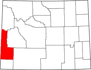 | |
| Towns | ||
| CDPs | ||
| Unincorporated communities | ||
| Footnotes | ‡This populated place also extends into Idaho | |