Agaléga
Agaléga (French: îles Agaléga) is a dependency of Mauritius which consists of two outer islands located in the Indian Ocean, about 1,050 km (650 mi) north of Mauritius Island. Under the Constitution of Mauritius, Agaléga is a constituent island of the Republic of Mauritius. However, India appears to be using the island for a purpose that has not yet been revealed but appears to be military,[1][2][3] it still remains, as explicitly defined by the Constitution of Mauritius, part of the Sovereignty of Mauritius, together with the following islands “Rodrigues, Tromelin, Cargados Carajos (Saint Brandon), Chagos Archipelago (…) Diego Garcia and other islands included in the State of Mauritius”.[4]
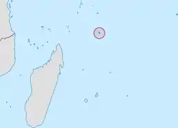 Location of the Agalega Islands in the Indian Ocean. | |
 | |
| Geography | |
|---|---|
| Location | Indian Ocean |
| Coordinates | 10°24′54″S 56°38′06″E |
| Total islands | 2 |
| Area | 24 km2 (9.3 sq mi) |
| Administration | |
| Dependency | Agaléga |
| Largest settlement | Vingt-Cinq |
| Demographics | |
| Population | 289 (2011) |
| Pop. density | 12/km2 (31/sq mi) |
| Ethnic groups | Creole |
Similarly to other Mauritian islands such as St. Brandon, Agaléga is run directly by the Prime Minister of Mauritius himself through the Prime Minister's Office to the Outer Island Development Corporation (OIDC).[5] The population of the islands in 2018 was 274[6] down from 289 in July 2011[7] amidst reports in the press that pregnant Agalégans are allegedly not allowed to give birth in Agaléga, possibly to avoid another Chagos-type problem in the future given that there are more than 200[8] Indian builders on site.
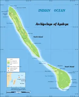
The islands have a total area of 2,600 ha (6,400 acres). The North island is 12.5 km (7.8 mi) long and 1.5 km (0.9 mi) wide, while the South island is 7 km (4.3 mi) long and 4.5 km (2.8 mi) wide. The North Island is home to the islands' airstrip and the capital Vingt-Cinq.[9] The islands are known for their production of coconuts which was their main industry and, also, for the Agalega day gecko.
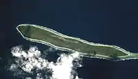
A 2015 memorandum of understanding on India–Mauritius military cooperation envisaged developing the Agaléga islands for an Indian military base.[10][11][12][13] Local residents vocally opposed construction of the base as being a threat to local employment, self-determination, creole language (Agalega creole), creole culture[14] and Mauritian sovereignty.[15][16] Satellite images in Google Earth indicate that a new airstrip and buildings adjacent to it were constructed in the period 2020–2023.
Etymology
There are three different explanations for the name Agaléga.
- One hypothesis is that the Portuguese explorer, Dom Pedro Mascarenhas, named Agaléga and the island of Sainte Marie (off the east coast of Madagascar) in honour of his two sailboats, the "Galega" and the "Santa Maria" in 1512, when he discovered Mauritius and Réunion Island.
- Another, more probable explanation relates to the Galician explorer João da Nova, who discovered the islands in 1501 while working for the Portuguese. João was popularly known by his sailors as João Galego, according to Jean-Baptiste Benoît Eyriès' Les Nouvelles Annales de Voyage (Volume 38, page 88). Galego is the Galician/Portuguese word for someone from Galicia, North West Spain, and "Agalega", is derived from the feminine version of this (a is the feminine article in Galician/Portuguese, and Galician illa for "island" is feminine, so a [ilha] galega would mean "the Galician [Island]"). or simply "from Galicia".
- A further, less likely, idea comes from a story in Sir Robert Scott's book Limuria: The Lesser Dependencies of Mauritius, where he describes the 1509 discovery of the Islands by the Portuguese mariner Diogo Lopes de Sequeira. According to this version, Diogo named the Islands Baixas da Gale, with the "da Gale" referring to putative gale-force winds hypothetically modelling the coasts of both islands. Scott suggests that maps of the region represented the islands initially as Gale, metamorphosing into Galera, Galega and finally Agalega.
History
As with the Mascarene islands, these islands may have been known to Arab and Malay sailors, although no written records have been found to confirm this. Agalega, or Galega, was examined by Captain Briggs of HMS Clorinde, on the 12th of January, 1811, who seems to have fixed its location accurately, which was previously not the case. The landing was found to be difficult on account of the heavy surf, the island being surrounded by a reef. A former French privateer was, at this time, settled on the island, having under him a colony of negroes, who cultivated part of the land[17] with maize and wheat.
The first settlement on the islands was founded by M. de Rosemond. Upon his arrival in August 1808, he discovered the bodies of two castaways and a bottle containing notes written by one of them, the privateer Robert Dufour. The only hill on the islands, Montagne d'Emmerez, derives its name from the second shipwrecked sailor, a Mauritian called Adelaide d'Emmerez.
Economic, infrastructural and political development of the islands didn't begin until the arrival of Auguste Le Duc in 1827, a French administrator sent by M. Barbé to organise production of coconut oil and copra. There still exists a number of historical monuments dating from the period 1827 to 1846, made by slaves: the village Vingt-Cinq (named after the 25 lashes that were given to rebellious slaves), the Slave Dungeons, an Oil Mill, a cemetery for Blacks and a cemetery for Whites, among others. Auguste Le Duc also began construction of a bridge between the two islands, although it was swept away by severe weather.
Father Victor Malaval brought the Catholic Church to the islands in 1897 as the first missionary. An improvised chapel was built on the South Island.
The origin of its inhabitants was influenced by the political ructions in the world at the time. Mauritius became a British colony in 1810 and the abolition of the slave trade then the abolition of slavery in 1835 followed by the arrival of unskilled Asian labourers. The slaves themselves were of Malagasy origin or from Madras in India whilst some were freed from slave ships and others were from the slave trading ports of the Comoros Islands.
Legends such as "Calèche Blanc" and "Princesse Malgache" are part of the folklore of the islands, as well as the coded language of "Madam langaz Seret" which has come down from the time of slavery. This language is a mixture of French and Mauritian Creole where every syllable is doubled with the first consonants replaced by the "g" (e.g. "Français" becomes "frangrançaisgais"). The origin, purpose and reasons for the evolution of this specific language remains unclear.
Today, the population consists of around 300 people, known locally as Agaléens ("Agalegans"), who speak Creole. Catholicism is the dominant religion. It is reported that more than 10,000 Agalegans today live in Mauritius itself.
Geography
North Island is 12.5 km (7.8 mi) long and 1.5 km (0.9 mi) wide while South Island is 7 km (4.3 mi) long and 4.5 km (2.8 mi) wide. The total area of both islands is 26 km2 (10 sq mi). The soil is likely coral. The culmination is at the top of the hill Emmer on the island in the north. The climate is hot and humid and the average annual temperature is 26 °C (79 °F), ranging from a minimum of 22.5 °C (72.5 °F) and a maximum of 30.6 °C (87.1 °F). April is the hottest month of the year. The tropical climate is conducive to the development of mangrove and coconut trees that cover the two islets.
Economy
Agaléga is managed by a company of the State of Mauritius, the Outer Island Development Company (OIDC),[18] a company which develops remote islands. The company delegates a resident manager, a kind of steward, who is the supreme authority on the two islets. The economy of the archipelago is based primarily on the exportation of coconut oil.
Cost of detachment of Agalega from Mauritius
The cost to the people from Agalega of being detached from their island so that India's military outpost can be installed has not yet been revealed. In Chagos' case, the financial "costs in 1965 were estimated at £10 million" (approximately £250 million today) excluding the United States' "secret contribution to the BIOT enterprise via waiving costs associated with Britain's nuclear weapons acquisitions, the financial costs for Britain to create BIOT was high. Acquiring Agaléga would have increased Britain's financial burden, at a time when it was winding down its vast empire and reigning in its defense spending."[19] This off-the-balance-sheet US nuclear help will almost certainly have doubled the initial cost to around £500 million in today's money. Mauritius does not produce nor hold nuclear weapons and the monetary quid pro quo relating to major infrastructural projects in Mauritius has also not been revealed. By way of example, "India has agreed to grant a Line of Credit (LOC) of USD 200 million to Mauritius as regards the Light Rail Transit project. An additional amount to the tune of USD 450 million from EXIM Bank of India at a very low interest rate will also be granted."[20]
Infrastructure
Most homes are in the main villages of Vingt-Cinq and La Fourche on the North Island, and St. Rita on the South Island. The road connecting the different localities is sandy and coral. The North Island is home to an airstrip, a government primary school "Jacques Le Chartier", the police station, the weather station, the central telecommunications office (Mauritius Telecom) and the health service. There is no running water on the island. Drinking water comes from rainwater collected by gutters. Water for other uses is sourced from wells. Electricity is supplied by generators running on diesel, with supply limited to certain hours. The company that manages the remote islands, such as Agaléga and St Brandon, is working on a project to ensure power supply to these islands, via submarine connection.
Agaléga is connected to Mauritius by air and sea. The civilian airstrip on the island in the north allows takeoff and landing of small aircraft. There is now a new 10,000 foot long modern airstrip suitable for jet aircraft.[21] There is no functional port on the islands, only a pier at St James Anchorage on the island's north. Vessels of the Mauritius Shipping Corporation (the Pride Mauritius and the Mauritius Trochetia) cast anchor about 500 m (1,600 ft) from this place, in the deep sea, during refueling.
Health services are provided by a health officer and a midwife. Doctors from Mauritius make short tours throughout the year. The Agaléens also receive a visit from a magistrate during the year.
For education, there is a primary school for the young, but pupils then continue their education in secondary schools on the island of Mauritius.
References
- Bashfield, Samuel. "Why is India building a military base on Agaléga island?". www.aljazeera.com. Archived from the original on 2023-02-01. Retrieved 2023-02-01.
- "Agalega: A glimpse of India's remote island military base". www.lowyinstitute.org. Archived from the original on 2022-12-25. Retrieved 2023-02-01.
- Auzine, Najaah. "[L.E]AGALEGA : MILITARY BASE FOR INDIA? | Sunday Times". Archived from the original on 2023-02-01. Retrieved 2023-02-01.
- "The Constitution of Mauritius" (PDF). p. 63. Archived (PDF) from the original on 2022-08-13. Retrieved 2023-02-01.
- "Outer Islands Development Corporation". Archived from the original on 2023-02-09. Retrieved 2023-02-03.
- Walter, Karen (2019-04-22). "Population en hausse: les Indiens ont pris le contrôle à Agalega". lexpress.mu (in French). Archived from the original on 2023-02-03. Retrieved 2023-02-03.
- "Geography − location". Government of Mauritius. Archived from the original on 2012-11-14. Retrieved 2012-07-25.
- Walter, Karen (2019-02-04). "Population en hausse: une catastrophe écologique guette Agalega". lexpress.mu (in French). Archived from the original on 2023-02-03. Retrieved 2023-02-03.
- "About Agalega". Government of Mauritius. Archived from the original on 2012-09-19. Retrieved 25 July 2012.
- "Republic of Mauritius- Development of Agalega – No Lease Agreement contained in MOU signed with India, says Minister Koonjoo". www.govmu.org. Archived from the original on 2022-12-10. Retrieved 2021-05-19.
- "India to develop strategic assets in 2 Mauritius, Seychelles islands". Indian Express. 2015-03-12. Archived from the original on 2015-03-11.
- "Naval muscle should fetch economic returns". The Tribune. 2015-03-20. Archived from the original on 2019-09-28.
- "India: Building a Sphere of Influence in the Indian Ocean? - RealClearDefense". Archived from the original on 2017-11-07. Retrieved 2018-04-08.
- "French Creoles | Creole Experience". www.frenchcreoles.com. Archived from the original on 2023-02-03. Retrieved 2023-02-03.
- "Agaléga islanders fear for future due to secret Indian navy base". Al Jazeera. Archived from the original on 2022-12-26. Retrieved 4 August 2021.
- Greene, Andrew (2021-08-04). "India building secretive base in Mauritius as it strengthens military ties with Australia". ABC News (Australia). Archived from the original on 2021-08-04. Retrieved 2021-08-04.
- India Directory 1826
- "The Outer Islands Development Corporation (OIDC) Act No. 41 of 1982". Archived from the original on 2016-04-24. Retrieved 2016-04-16.
- "Agaléga's Strategic Value: in the Eye of the Beholder". Asia Maritime Transparency Initiative. 2022-11-29. Archived from the original on 2023-02-03. Retrieved 2023-02-07.
- "Mauritius: India Grants Mauritius LOC U.S.$200 Million for Light Rail Transit Project". Retrieved 7 February 2023.
- "New Indian Express:Aug 3rd, 2021: India believed to be building naval facility on Mauritian island of Agalega". Archived from the original on 2021-11-22. Retrieved 2021-11-22.
External links
- Government of Mauritius - Agalega Archived 2015-04-02 at the Wayback Machine
Islands of Mauritius | |||||
|---|---|---|---|---|---|
| Outer Islands | .svg.png.webp) | ||||
| Islets |
| ||||
| Fishing banks | |||||
| Claims/Disputed | |||||
| Subdivisions |
| | ||||||||||||
|---|---|---|---|---|---|---|---|---|---|---|---|---|---|---|
| Politics | ||||||||||||||
| Economy | ||||||||||||||
| Society |
| |||||||||||||