Agassiz, British Columbia
Agassiz (/ˈæɡəsi/ AG-ə-see)[1] is a small community located in the Eastern Fraser Valley region of British Columbia, Canada, about 97 kilometres east of Vancouver and 24 kilometres north-east of the city of Chilliwack.[2] The only town within the jurisdiction of the District Municipality of Kent, it contains the majority of Kent's population.
Agassiz | |
|---|---|
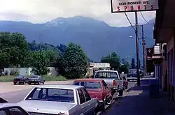 A view of the mountains from the street | |
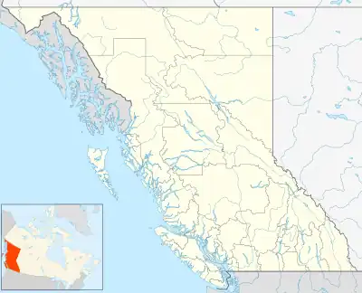 Agassiz Location in British Columbia | |
| Coordinates: 49°14′20.19″N 121°45′57.18″W | |
| Country | Canada |
| Province | British Columbia |
| Regional district | Fraser Valley |
| Named for | Lewis Nunn Agassiz, a member of the Agassiz family |
History
The land on the Fraser that is now called Agassiz was once the location of villages of the First Nation Steaten people that had been wiped out by disease starting in 1782.[3] Later, another village of former First Nation slaves settled there called Freedom Village (Halkomelem: Chi'ckim).[3]
Agassiz was founded by Lewis Nunn Agassiz, a member of the Agassiz family.
TV drama Wayward Pines was filmed on location in the community.
Climate
Agassiz has an oceanic climate (Cfb) with warm summers with cool nights and cool, rainy winters.[4] Mid-summer to early fall is generally the driest time of the year, with only 1 out of every 3 days on average having precipitation.
| Climate data for Agassiz, British Columbia | |||||||||||||
|---|---|---|---|---|---|---|---|---|---|---|---|---|---|
| Month | Jan | Feb | Mar | Apr | May | Jun | Jul | Aug | Sep | Oct | Nov | Dec | Year |
| Record high °C (°F) | 17.2 (63.0) |
21.7 (71.1) |
25.8 (78.4) |
32.2 (90.0) |
36.0 (96.8) |
41.4 (106.5) |
38.3 (100.9) |
39.4 (102.9) |
36.8 (98.2) |
29.6 (85.3) |
21.1 (70.0) |
17.2 (63.0) |
41.4 (106.5) |
| Average high °C (°F) | 6.2 (43.2) |
8.5 (47.3) |
11.6 (52.9) |
15.0 (59.0) |
18.5 (65.3) |
21.1 (70.0) |
24.0 (75.2) |
24.6 (76.3) |
21.3 (70.3) |
15.0 (59.0) |
8.9 (48.0) |
5.8 (42.4) |
15.0 (59.0) |
| Daily mean °C (°F) | 3.4 (38.1) |
5.1 (41.2) |
7.5 (45.5) |
10.4 (50.7) |
13.6 (56.5) |
16.2 (61.2) |
18.5 (65.3) |
18.7 (65.7) |
15.9 (60.6) |
11.0 (51.8) |
6.1 (43.0) |
3.2 (37.8) |
10.8 (51.4) |
| Average low °C (°F) | 0.5 (32.9) |
1.6 (34.9) |
3.4 (38.1) |
5.6 (42.1) |
8.8 (47.8) |
11.3 (52.3) |
12.8 (55.0) |
12.8 (55.0) |
10.3 (50.5) |
6.9 (44.4) |
3.2 (37.8) |
0.5 (32.9) |
6.5 (43.7) |
| Record low °C (°F) | −25.0 (−13.0) |
−24.4 (−11.9) |
−14.4 (6.1) |
−3.9 (25.0) |
−1.1 (30.0) |
1.7 (35.1) |
3.3 (37.9) |
1.7 (35.1) |
−1.1 (30.0) |
−8.5 (16.7) |
−19.0 (−2.2) |
−21.1 (−6.0) |
−25.0 (−13.0) |
| Average precipitation mm (inches) | 240.8 (9.48) |
142.1 (5.59) |
154.7 (6.09) |
125.9 (4.96) |
103.0 (4.06) |
92.2 (3.63) |
66.6 (2.62) |
58.2 (2.29) |
87.6 (3.45) |
191.7 (7.55) |
285.0 (11.22) |
206.1 (8.11) |
1,754.1 (69.06) |
| Average rainfall mm (inches) | 220.8 (8.69) |
131.1 (5.16) |
148.8 (5.86) |
125.5 (4.94) |
103.0 (4.06) |
92.2 (3.63) |
66.6 (2.62) |
58.2 (2.29) |
87.6 (3.45) |
191.6 (7.54) |
275.8 (10.86) |
187.7 (7.39) |
1,688.9 (66.49) |
| Average snowfall cm (inches) | 20.3 (8.0) |
12.5 (4.9) |
5.8 (2.3) |
0.4 (0.2) |
0 (0) |
0 (0) |
0 (0) |
0 (0) |
0 (0) |
0.2 (0.1) |
9.2 (3.6) |
19.0 (7.5) |
67.4 (26.6) |
| Average precipitation days (≥ 0.2 mm) | 19.2 | 17.3 | 19.9 | 17.8 | 17.1 | 15.0 | 10.4 | 10.1 | 11.7 | 17.1 | 21.3 | 20.0 | 196.9 |
| Average rainy days (≥ 0.2 mm) | 16.8 | 15.8 | 19.6 | 17.8 | 17.1 | 15.0 | 10.4 | 10.1 | 11.7 | 17.1 | 20.7 | 18.1 | 190.1 |
| Average snowy days (≥ 0.2 cm) | 4.6 | 2.8 | 1.0 | 0.2 | 0 | 0 | 0 | 0 | 0 | 0.07 | 1.3 | 3.9 | 13.87 |
| Mean monthly sunshine hours | 57.8 | 85.7 | 127.7 | 163.9 | 194.2 | 195.6 | 255.8 | 242.2 | 196.8 | 122.2 | 60.2 | 53.6 | 1,755.6 |
| Source: Environment Canada[5][6][7] | |||||||||||||
Government and infrastructure
Correctional Service of Canada (CSC) Kent Institution is in Agassiz.
Gallery
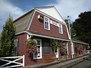 The Agassiz-Harrison Museum
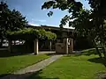 District of Kent District Hall and Public Library, Agassiz, BC.
References
- The Canadian Press (2017), The Canadian Press Stylebook (18th ed.), Toronto: The Canadian Press)
- "Agassiz (Community)". BC Geographical Names.
- Carlson 2010, p. 142.
- "Agassiz, Bc Climate Agassiz, Bc Temperatures Agassiz, Bc Weather Averages". www.agassiz.climatemps.com. Retrieved 2023-03-22.
- "Canadian Climate Normals 1981-2010 at station AGASSIZ CDA". Environment Canada. 2013-07-01. Retrieved 2014-01-02.
- "Daily Data Report for September 2017 - Climate - Environment and Climate Change Canada".
- "Daily Data Report for June 2021 - Climate - Environment and Climate Change Canada".
- Carlson, Keith Thor (2010). The Power of Place, the Problem of Time: Aboriginal Identity and Historical Consciousness in the Cauldron of Colonialism. University of Toronto Press. ISBN 9781442699960. - Total pages: 368
Subdivisions of British Columbia | |
|---|---|
| Subdivisions | |
| Communities | |
| Metro areas and agglomerations | |
| Detached communities within district municipalities |
|
| |