Akdoğan Mountains
Akdoğan Mountains (Turkish: Akdoğan Dağları or Hamurpert Dağları); (Armenian: Xamurpert or Khamur); is a mountain range located at the zero point of the Muş and Erzurum border. It extends from the east of Akdoğan lake to Karaçoban district by crossing the border where Varto, Bulanık and Hınıs districts intersect.[1] [2][3]
| Akdoğan Mountains | |
|---|---|
 View of forests | |
| Highest point | |
| Elevation | 2.879 m (9.45 ft) |
| Prominence | 2.503 m (8.21 ft) |
| Coordinates | 39°11′05″N 41°51′42″E |
| Dimensions | |
| Length | 30 km (19 mi) |
| Width | 10 km (6.2 mi) |
| Geography | |
 Akdoğan Mountains Turkey | |
| Location | Muş Province, Erzurum Province, Turkey |
| Geology | |
| Mountain type | Volcanic |
Geology and geomorphology
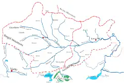
Akdoğan mountains appear as a mountain mass between the Hınıs plain and the Murat river.[4] [5] It includes Akdoğan Lake, one of Turkey's highest and well-preserved lakes. Akdoğan Mountains are one of the important wetlands for birds and there are more than 100 small and shallow lakes on it. Most of the lakes are located around the Hınıs villages, located north of the 2879 meter peak.[6] Akdoğan Mountains are one of the highest mountains in Muş province and have the most organized forests. Mount Süphan is visible even in the lowest parts of the region. The width of the Akdoğan mountains is 10 km and the length is 30 km.[7] As a result of the volcanic eruptions in the Akdoğan Mountains, Akdoğan crater lakes was formed. There is Mount Göztepe at the southern foothills of the Akdoğan Mountains.
Flora
The main plant species in the Akdoğan mountains are Toxic Ferula and non-toxic Ferula, Rheum ribes, Gundelia, Sorrel, Arum maculatum, Asphodelus, Paeonia turcica and Astragalus kurdicus.
References
- "Erzurum Mülkî İdare İl Haritası" (PDF). harita.gov.tr. Harita Genel Müdürlüğü. p. 1.
- "Akdoğan (Hamurpet) Dağı" (in Turkish). Muş İl Kültür ve Turizm Müdürlüğü. September 25, 2023. Archived from the original on September 26, 2020.
- "Muş il fiziki haritası" (PDF) (in Turkish). Harita genel müdürlüğü. September 28, 2023. Archived (PDF) from the original on August 18, 2023.
- "Muş ili'nde yaylaların dağılışı" (PDF) (in Turkish). Turkish Studies. International Balkan University. March 2019. p. 22.
- "Kaza of Bulanık - Geography". houshamadyan.org (in Turkish). Retrieved 2017-10-25.
- "Akdoğan Dağları" (PDF). dogadernegi.org. Doğa Derneği. 31 October 2018. p. 1.
- "Muş'un coğrafi yapısı". mus.ktb.gov.tr. Muş İl Kültür ve Turizm Müdürlüğü.