Akseki
Akseki is a municipality and district of Antalya Province, Turkey.[2] Its area is 1,544 km2,[3] and its population is 10,477 (2022).[1]
Akseki | |
|---|---|
District and municipality | |
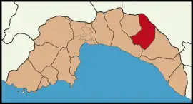
 Map showing Akseki District in Antalya Province | |
 Akseki Location in Turkey | |
| Coordinates: 37°02′55″N 31°47′24″E | |
| Country | Turkey |
| Province | Antalya |
| Government | |
| • Mayor | İbrahim Özkan (AKP) |
| Area | 1,544 km2 (596 sq mi) |
| Elevation | 1,100 m (3,600 ft) |
| Population (2022)[1] | 10,477 |
| • Density | 6.8/km2 (18/sq mi) |
| Time zone | TRT (UTC+3) |
| Area code | 0242 |
| Website | www |
Known for its snowdrops, Akseki is located in the western Taurus Mountains at an elevation of 1100m. The Manavgat River passes through a large valley in the centre of the district, which is otherwise mainly mountainous. Places of interest include caves, valleys and a number of high meadows. This windswept rocky mountainside is not good farmland and the local economy mostly depends on forestry and raising sheep and cattle. Many people from Akseki have migrated to Antalya but still have homes here as an escape from the summer heat on the coast. The people of Akseki have a reputation as canny traders, and some prominent businessman were brought up here including restaurateur and fruit-juice producer Ömer Duruk.
Akseki was formerly Byzantine town of Marla, Marulya, or Marulia. It was conquered by the Seljuk Turks and the Ottoman Empire along with other towns in the area.
Antalya's Akdeniz University has a branch here training nurses, and doing some other vocational training.
With its rich architectural heritage, Akseki is a member of the Norwich-based European Association of Historic Towns and Regions.[4]
The country boasts an economy based on cattle and almond trade.
Composition
There are 51 neighbourhoods in Akseki District:[5]
- Akşahap
- Alaçeşme
- Aşağıaşıklar
- Bademli
- Belenalan
- Boğaz
- Bucakalan
- Bucakkışla
- Büyükalan
- Çaltılıçukur
- Çanakpınar
- Ceceler
- Cemerler
- Cendeve
- Cevizli
- Çimiköy
- Çınardibi
- Çukurköy
- Değirmenlik
- Demirciler
- Dikmen
- Dutluca
- Emiraşıklar
- Erenyaka
- Fakılar
- Geriş
- Güçlüköy
- Gümüşdamla
- Güneykaya
- Günyaka
- Güzelsu
- Hacıilyas
- Hocaköy
- Hüsamettinköy
- Karakışla
- Kepez
- Kepezbeleni
- Kuyucak
- Mahmutlu
- Menteşbey
- Minareli
- Pınarbaşı
- Sadıklar
- Salihler
- Sarıhacılar
- Sarıhaliller
- Sinanhoca
- Süleymaniye
- Susuzşahap
- Taşlıca
- Yarpuz
References
- "Address-based population registration system (ADNKS) results dated 31 December 2022, Favorite Reports" (XLS). TÜİK. Retrieved 22 May 2023.
- Büyükşehir İlçe Belediyesi, Turkey Civil Administration Departments Inventory. Retrieved 8 June 2023.
- "İl ve İlçe Yüz ölçümleri". General Directorate of Mapping. Retrieved 22 May 2023.
- The European Association of Historic Towns and Regions - Turkey Archived 2008-09-10 at the Wayback Machine
- Mahalle, Turkey Civil Administration Departments Inventory. Retrieved 22 May 2023.
