Ismailia Governorate
Ismailia Governorate (Arabic: محافظة الإسماعيلية) is one of the Canal Zone governorates of Egypt. Located in the northeastern part of the country, its capital is the city of Ismailia. It was named after Ismail Pasha, who as Ottoman Viceroy of Egypt, oversaw the country during the building of the Suez Canal.[6] It is located between the other two Canal governorates; Port Said Governorate, in the Northern part of Egypt and Suez Governorate.[7]
Ismailia Governorate | |
|---|---|
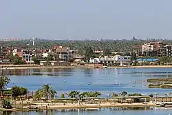 View of Ismailia and Timash lake | |
 Flag  | |
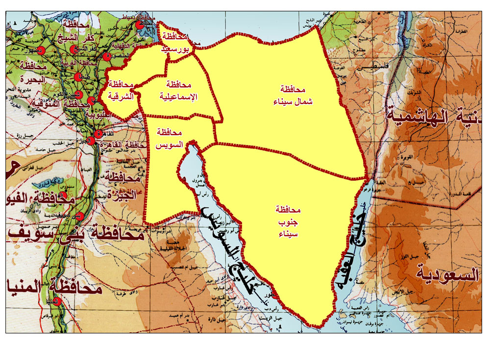
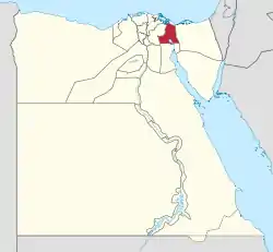 Ismailia Governorate on the map of Egypt | |
| Country | |
| Seat | Ismailia (capital) |
| Government | |
| • Governor | Hamdi Hamed Mohamed Osman[1] |
| Area | |
| • Total | 5,066 km2 (1,956 sq mi) |
| Population (January 2023)[4] | |
| • Total | 1,442,402 |
| • Density | 280/km2 (740/sq mi) |
| Time zone | UTC+2 (EET) |
| HDI (2021) | 0.745[5] high · 8th |
| Website | www |
.jpg.webp)
| Year | Pop. | ±% |
|---|---|---|
| 1966 | 345,000 | — |
| 1976 | 351,889 | +2.0% |
| 1986 | 544,427 | +54.7% |
| 1996 | 715,009 | +31.3% |
| 2006 | 942,832 | +31.9% |
| 2015 | 1,178,641 | +25.0% |
| 2023 | 1,442,402 | +22.4% |
| 1966–2006, 2015 is an estimate[8][4] | ||
Municipal divisions
The governorate is divided into municipal divisions, with a total estimated population as of January 2023 of 1,442,402. In the case of Ismailia governorate, there are 4 kism, 5 markaz and 1 new city.[4]
The divisions are generally seven: Ismailia which is the capital, Tell El Kebir, Abu Suwir, Qassasin, Fayid, Qantara West and Qantara East.[9][10]
| Anglicized name | Native name | Arabic transliteration | Population (July 2017 Est.) | Type |
|---|---|---|---|---|
| Abu Suwir | مركز أبو صوير | Abū Ṣuwīr | 221,994 | Markaz |
| Ismailia | مركز الاسماعيلية | Al-Ismā'īliyah | 170,065 | Markaz |
| Ismailia 1 | قسم أول الاسماعيلية | Al-Ismā'īliyah 1 | 49,859 | Kism (fully urban) |
| Ismailia 2 | قسم ثان الاسماعيلية | Al-Ismā'īliyah 2 | 264,376 | Kism (fully urban) |
| Ismailia 3 | قسم ثالث الاسماعيلية | Al-Ismā'īliyah 3 | 131,422 | Kism (fully urban) |
| El Qantara West | مركز القنطرة غرب | Al-Qanṭarah Gharb | 162,101 | Markaz |
| El Qantara El Sharqiya | مركز القنطرة شرق | Al-Qanṭarah Sharq | 62,600 | Markaz |
| New Kasaseen | مركز القصاصين الجديده | Al-Qaṣāṣīn al-Jadīdah | 120,788 | New City |
| Tell El Kebir | مركز التل الكبير | At-Tall al-Kabīr | 111,635 | Markaz |
| Fayid | مركز فايد | Fa'id | 147,562 | Markaz |
Population
According to population estimates, in 2015 the majority of residents in the governorate lived in rural areas, with an urbanization rate of only 45.4%. Out of an estimated 1,178,641 people residing in the governorate, 643,778 people lived in rural areas as opposed to only 534,863 in urban areas.[11]
Cities and towns
As of 2017, seven cities (or towns) in Ismailia had a population of over 15,000 inhabitants.[12]
| Anglicized name | Native name | Arabic transliteration | Nov. 1996 Census | Nov. 2006 Census | Population (July 2017 Est.) |
|---|---|---|---|---|---|
| Abu Suwir El Mahata | أبو صوير المحطة | Abū Ṣuwayr al-Maḥaṭṭah | 18,331 | 24,265 | 29,476 |
| Ismalia | الإسماعيلية | Al-Ismā'īliyah | 255,134 | 293,184 | 386,372 |
| New Kasaseen | القصاصين الجديدة | Al-Qaṣāṣīn al-Jadīdah | 11,948 | 15,611 | 22,000 |
| Tell El Kebir | التل الكبير | At-Tall al-Kabīr | 31,410 | 26,891 | 37,000 |
| Fayid | فايد | Fa'id | 15,652 | 21,808 | 31,545 |
Industrial zones
According to the Egyptian Governing Authority for Investment and Free Zones (GAFI), in affiliation with the Ministry of Investment (MOI), the following industrial zones are located in this governorate:[13]
- Al Qantara Shark
- The 1st industrial zone
- Technology Valley
- The 2nd industrial zone
- Abu Khalifa
Annual film festival
Hashim El Nahas founded the Ismailia International Film Festival for Documentaries and Shorts and originally considered establishing it in Luxor. Instead this festival has been celebrating its annual events in Ismailia Governorate. It is sponsored by the Ministry of Culture, Ismailia Governorate, The National Cinema Center and other sponsors.[14]
Ismailia Canal
The Ismailia Governorate is on the banks of the Suez Canal and its Ismailia Canal extends from the Nile River near Cairo, to the Suez Canal at the city of Ismailia, on Lake Timsah.[15] The Ismailia Canal was built to provide fresh water to workers during the building of the Suez Canal.[7] The Suez Canal Authority headquarters is located in Ismailia.[16]
Conflicts and wars
From 1967 to 1970, Ismailia became a war zone and was damaged in the conflict with Israel. Many battles were fought, in and around Ismailia, including at the end of the conflict in the Battle of Ismailia[17] and the area was able to begin rebuilding after a cease-fire was negotiated between Egypt and Israel in 1973.[18][19]
Fishing landing sites
There are several official fishing landing sites in Ismailia. One is at Lake Timsah and the other at Bitter Lake.[20][21]
UN sustainable programme
After a successful SIP (Sustainable Ismailia Programme) from 1992 to 1997, the United Nations expanded the project to include the entire Governorate of Ismailia calling it SGIP (Sustainable Ismailia Governorate Programme). Its goal is to work with local partners to improve the communities in Ismailia.[22]
References
- "رسمياً.. المحافظون الجدد ونوابهم يؤدون اليمين الدستورية أمام الرئيس". Almasry Alyoum (in Arabic). 30 August 2018. Archived from the original on 2018-08-31. Retrieved 2018-08-31.
- "Ismailia Governorate Subdivisions". CityPopulation.de. Archived from the original on 2018-11-24. Retrieved 2018-11-24.
- "About the governorate". www.ismailia.gov.eg. Retrieved 13 December 2018.
- (PDF) https://www.capmas.gov.eg/Admin/Pages%20Files/202331512347%D8%B9%D8%AF%D8%AF%20%D8%A7%D9%84%D8%B3%D9%83%D8%A7%D9%86%20%D8%B9%D9%84%D9%89%20%D9%85%D8%B3%D8%AA%D9%88%D9%89%20%D8%A7%D9%84%D9%85%D8%B1%D8%A7%D9%83%D8%B2%20%D9%88%D8%A7%D9%84%D8%A7%D9%82%D8%B3%D8%A7%D9%85%20%D9%81%D9%89%201%D9%80%201%D9%80%202023.pdf. Retrieved 2 April 2023.
{{cite web}}: Missing or empty|title=(help) - "Sub-national HDI - Subnational HDI - Table - Global Data Lab". globaldatalab.org. Retrieved 2023-02-20.
- "Ismail-Pasha". Britannica. Archived from the original on 19 October 2016. Retrieved 16 October 2016.
- "Al-Ismailiyyah". Britannica. Archived from the original on 19 October 2016. Retrieved 17 October 2016.
- "Ismailia Population, 1966–2006". Statoids. Archived from the original on October 14, 2016. Retrieved October 16, 2016.
- "Ismailia site". ismailia.gov.eg (in Arabic). Ismailia Government.
- "Map of Ismailia". ismailia.gov.eg. Ismailia Government. Archived from the original on 2018-02-24. Retrieved 2018-11-26.
- "Population Estimates By Sex & Governorate 1/1/2015" (PDF). CAPMAS. Archived (PDF) from the original on 19 October 2015. Retrieved 23 October 2016.
- "Cities". CityPopulation.de. Archived from the original on 2018-10-05. Retrieved 2018-11-24.
- "Industrial Zones of Governorate". Ministry of Investment Egypt. Archived from the original on 2018-11-23. Retrieved 23 November 2018.
- "Ismailia International Film Festival For Documentaries and Shorts". Ismailia FilmFestival. Archived from the original on 23 October 2016. Retrieved 23 October 2016.
- Merriam Webster's Geographical Dictionary (3rd ed.). 1997. p. 535. ISBN 0-87779-546-0.
- "Suez Canal". Suez Canal Government of Egypt. Archived from the original on 2016-10-18. Retrieved 2016-10-17.
- Dunstan, Simon (20 November 2012). The Yom Kippur War 1973 (2): The Sinai. Bloomsbury Publishing. p. 9. ISBN 9781846036484.
- Tucker, Spencer C. (2015). Wars That Changed History: 50 of the World's Greatest Conflicts. ABC-CLIO. p. 549. ISBN 9781610697866.
- Potholm, Christian P. (2016). Understanding War: An Annotated Bibliography. UPA. p. 584. ISBN 9780761867746.
- "Fishery and Aquaculture Country Profiles The Arab Republic of Egypt". Food and Agriculture Organization of the United Nations. Archived from the original on 16 October 2016. Retrieved 16 October 2016.
- "Information on Fisheries Management in the Arab Republic of Egypt". FOA. Archived from the original on 6 April 2012. Retrieved 16 October 2016.
- Sustainable Cities Programme 1990-2000: A Decade of United Nations Support for Broad-based Participatory Management of Urban Development. UN. 2002. p. 30. ISBN 9789211316322.
Further reading
- "Ismailia – Egypt's Garden City", Community Times Magazine
- Water Polo Legends: 1930's in Ismailia, Egypt
External links
- Official Ismailia Governorate
- Ismailia Governorate - Tourism
- Tour Egypt, Ismailia Governorate Sites
- Supreme Council of Antiquities, Ismailia Museum
- Ismailia Governorate on Facebook
- El Watan News of Ismailia Governorate
| Urban | ||
|---|---|---|
| Lower Egypt | ||
| Upper Egypt | ||
| Frontier | ||
| Authorities |  | ||||||
|---|---|---|---|---|---|---|---|
| Cities and ports | |||||||
| Infrastructure |
| ||||||
| Marine life | |||||||
| History |
| ||||||