Alma, Georgia
Alma is a city in Bacon County, Georgia, United States, and the county seat.[4] As of the 2020 census, the city had a population of 3,433.
Alma, Georgia | |
|---|---|
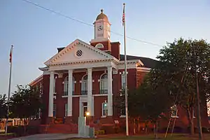
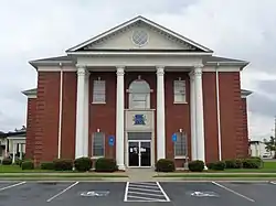 Alma City services in Bacon County Courthouse | |
| Nickname: "Georgia's Blueberry Capital" | |
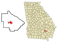 Location in Bacon County and the state of Georgia | |
| Coordinates: 31°32′30″N 82°28′0″W | |
| Country | United States |
| State | Georgia |
| County | Bacon |
| Government | |
| • Mayor | Larry Taylor |
| Area | |
| • Total | 6.22 sq mi (16.11 km2) |
| • Land | 6.09 sq mi (15.78 km2) |
| • Water | 0.13 sq mi (0.33 km2) |
| Elevation | 200 ft (61 m) |
| Population (2020) | |
| • Total | 3,433 |
| • Density | 563.53/sq mi (217.57/km2) |
| Time zone | UTC-5 (Eastern (EST)) |
| • Summer (DST) | UTC-4 (EDT) |
| ZIP code | 31510 |
| Area code | 912 |
| FIPS code | 13-01612[2] |
| GNIS feature ID | 0310492[3] |
| Website | www |
Alma is known as Georgia's blueberry capital, and hosts a Blueberry Festival each June.
History
Alma was founded in 1900 as a stop on the Atlantic Coast Line Railroad. It was incorporated as a city in 1906 and designated seat of the newly formed Bacon County in 1914.[5] There are two theories about the origin of the name of the town. The first is that it was named for the wife of a traveling salesmen, Alma Sheridan; the other is that it was named for the initial letter of the four state capitals Georgia has had: Augusta, Louisville, Milledgeville, and Atlanta.[6][7]
There are four sites in Alma listed on the National Register of Historic Places: Alma Depot, Bacon County Courthouse, Bacon County School, and the Rabinowitz Building.
Geography
Alma is located in southeastern Georgia at 31°32′30″N 82°28′0″W (31.541543, -82.466666).[8]
The city is located along U.S. Routes 1 and 23 (Pierce Street). The two run through the center of the city together before splitting just north of the city. U.S. 1 connects the city with Baxley, 19 mi (31 km) to the north, and U.S. 23 connects the city with Hazlehurst, 25 mi (40 km) to the northwest. U.S. 1/23 also lead south together 29 mi (47 km) to Waycross. Other highways that run through the city include Georgia State Routes 32 (16th Street) and 64 (Market Street).
According to the United States Census Bureau, the city has a total area of 6.2 square miles (16.1 km2), of which 5.5 square miles (14.3 km2) is land and 0.69 square miles (1.8 km2), or 11.27%, is water.[9]
Demographics
| Census | Pop. | Note | %± |
|---|---|---|---|
| 1910 | 458 | — | |
| 1920 | 1,061 | 131.7% | |
| 1930 | 1,235 | 16.4% | |
| 1940 | 1,840 | 49.0% | |
| 1950 | 2,588 | 40.7% | |
| 1960 | 3,515 | 35.8% | |
| 1970 | 3,756 | 6.9% | |
| 1980 | 3,819 | 1.7% | |
| 1990 | 3,663 | −4.1% | |
| 2000 | 3,236 | −11.7% | |
| 2010 | 3,466 | 7.1% | |
| 2020 | 3,433 | −1.0% | |
| U.S. decennial census[10] | |||
2020 census
| Race | Number | Percentage |
|---|---|---|
| White (non-Hispanic) | 1,599 | 46.58% |
| Black or African American (non-Hispanic) | 1,455 | 42.38% |
| Native American | 2 | 0.06% |
| Asian | 25 | 0.73% |
| Pacific Islander | 3 | 0.09% |
| Other/Mixed | 105 | 3.06% |
| Hispanic or Latino | 244 | 7.11% |
As of the 2020 United States census, there were 3,433 people, 1,005 households, and 620 families residing in the city.
2000 census
As of the census[2] of 2000, there were 3,236 people, 1,243 households, and 826 families residing in the city. The population density was 564.6 inhabitants per square mile (218.0/km2). There were 1,510 housing units at an average density of 263.5 per square mile (101.7/km2). The racial makeup of the city was 57.97% White, 38.57% African American, 0.09% Native American, 0.49% Asian, 1.89% from other races, and 0.99% from two or more races. Hispanic or Latino of any race were 4.42% of the population.
There were 1,243 households, out of which 30.2% had children under the age of 18 living with them, 37.7% were married couples living together, 24.9% had a female householder with no husband present, and 33.5% were non-families. 30.1% of all households were made up of individuals, and 14.9% had someone living alone who was 65 years of age or older. The average household size was 2.50 and the average family size was 3.06.
In the city, the population was spread out, with 26.5% under the age of 18, 10.5% from 18 to 24, 24.0% from 25 to 44, 20.9% from 45 to 64, and 18.0% who were 65 years of age or older. The median age was 36 years. For every 100 females there were 83.3 males. For every 100 females age 18 and over, there were 76.3 males.
The median income for a household in the city was $20,324, and the median income for a family was $21,941. Males had a median income of $25,362 versus $15,583 for females. The per capita income for the city was $11,574. About 27.6% of families and 32.3% of the population were below the poverty line, including 48.7% of those under age 18 and 24.2% of those age 65 or over.
Education
Alma is served by the Bacon County School District.[12] The district has 126 full-time teachers and over 1,900 students,[13] and operates these schools:
- Bacon County Elementary School
- Bacon County Primary School
- Bacon County Middle School
- Bacon County High School
Alma is also served by Coastal Pines Technical College.
Notable people
- Harry Crews, novelist, playwright, short story writer and essayist
- Braswell Deen, U.S. Representative from Georgia; moved to Alma
- Daniel W. Lee, recipient of Congressional Medal of Honor
- Walter J. Leonard, former president of Fisk University
- William M. Wheeler, U.S. Representative from Georgia
References
- "2020 U.S. Gazetteer Files". United States Census Bureau. Retrieved December 18, 2021.
- "U.S. Census website". United States Census Bureau. Retrieved January 31, 2008.
- "US Board on Geographic Names". United States Geological Survey. October 25, 2007. Retrieved January 31, 2008.
- "Find a County". National Association of Counties. Archived from the original on May 31, 2011. Retrieved June 7, 2011.
- Hellmann, Paul T. (May 13, 2013). Historical Gazetteer of the United States. Routledge. p. 216. ISBN 978-1135948597. Retrieved November 30, 2013.
- "Alma". Georgia.gov. Retrieved December 28, 2016.
- Krakow, Kenneth K. (1975). Georgia Place-Names: Their History and Origins (PDF). Macon, GA: Winship Press. p. 4. ISBN 0-915430-00-2.
- "US Gazetteer files: 2010, 2000, and 1990". United States Census Bureau. February 12, 2011. Retrieved April 23, 2011.
- "Geographic Identifiers: 2010 Demographic Profile Data (G001): Alma city, Georgia". U.S. Census Bureau, American Factfinder. Archived from the original on February 12, 2020. Retrieved October 24, 2013.
- "Census of Population and Housing". Census.gov. Retrieved June 4, 2015.
- "Explore Census Data". United States Census Bureau. Retrieved December 18, 2021.
- Georgia Board of Education, Retrieved July 28, 2010.
- Free District Report, Retrieved May 29, 2010.
External links
Municipalities and communities of Bacon County, Georgia, United States | ||
|---|---|---|
| City | 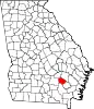 Map of Georgia highlighting Bacon County | |
| CDP | ||
| Unincorporated community | ||