Estrada de Ferro do Amapá
The Amapá Railway is a former rail line built by Bethlehem Steel[1] to exploit the manganese deposits in the territory of Amapá (now a state), Brazil. It is 4 ft 8+1⁄2 in (1,435 mm) standard gauge, the only railway in the country to use this gauge aside from Line 5 of the São Paulo Metro. The line was also in use for passenger transport.[2]
| Amapá Railway | ||||||||||||||||||||||||||||||||||||||||||||||||
|---|---|---|---|---|---|---|---|---|---|---|---|---|---|---|---|---|---|---|---|---|---|---|---|---|---|---|---|---|---|---|---|---|---|---|---|---|---|---|---|---|---|---|---|---|---|---|---|---|
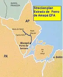
 Map of the line | ||||||||||||||||||||||||||||||||||||||||||||||||
| Overview | ||||||||||||||||||||||||||||||||||||||||||||||||
| Native name | Estrada de Ferro do Amapá | |||||||||||||||||||||||||||||||||||||||||||||||
| Status | Ceased operation | |||||||||||||||||||||||||||||||||||||||||||||||
| Owner | Bethlehem Steel / MMX Mineração e Metálicos | |||||||||||||||||||||||||||||||||||||||||||||||
| Locale | Amapá, Brazil | |||||||||||||||||||||||||||||||||||||||||||||||
| Termini | ||||||||||||||||||||||||||||||||||||||||||||||||
| Stations | 5 | |||||||||||||||||||||||||||||||||||||||||||||||
| Service | ||||||||||||||||||||||||||||||||||||||||||||||||
| Type | Freight rail & Passenger rail | |||||||||||||||||||||||||||||||||||||||||||||||
| Technical | ||||||||||||||||||||||||||||||||||||||||||||||||
| Line length | 194 kilometres (121 mi) | |||||||||||||||||||||||||||||||||||||||||||||||
| Character | At-grade | |||||||||||||||||||||||||||||||||||||||||||||||
| Track gauge | 4 ft 8+1⁄2 in (1,435 mm) standard gauge | |||||||||||||||||||||||||||||||||||||||||||||||
| ||||||||||||||||||||||||||||||||||||||||||||||||
The line was about 194 kilometres (121 mi), spanning from mines near Serra do Navio to the port city of Santana.[3] The rail line stopped transporting ore in 2014,[3] and as of 2020, remains derelict.[4]
See also
References
- "Exploração de manganês pela ICOMI: passivo ambiental para a população de Serra do Navio". Conflictos Mineros (in Portuguese). Retrieved 3 April 2021.
- "Estrada de Ferro Amapá - EFA" (in Portuguese). Archived from the original on 2011-08-04. Retrieved 3 April 2021.
- "Sem uso, estação e ferrovia de 194 km no Amapá são alvos de saques e invasões há cinco anos". G1 (in Brazilian Portuguese). Retrieved 2021-03-27.
- "Dupla caminhará 200 quilômetros para documentar em vídeo como está a Estrada de Ferro do Amapá". G1 (in Brazilian Portuguese). Retrieved 2021-03-27.
This article is issued from Wikipedia. The text is licensed under Creative Commons - Attribution - Sharealike. Additional terms may apply for the media files.