An'yō-in (Kamakura)
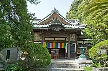
Gionzan An’yō-in Chōraku-ji (祇園山安養院長楽寺) is a Jōdo shū Buddhist temple in Kamakura, Kanagawa, Japan.[1] Famous for its rhododendrons, it was named after its founder's (great historical figure Hōjō Masako) posthumous name.[1] The main object of worship is Amida Nyorai,[2] but it also enshrines Senju Kannon, Goddess of Mercy. An’yō-in is Number three of the 33 temples of the Bandō Sanjūsankasho pilgrimage circuit.[2]
| Gionzan An’yō-in Chōraku-ji | |
|---|---|
 An'yō-in, Kamakura. The Main Hall | |
| Religion | |
| Affiliation | Jōdo |
| Location | |
| Location | Ōmachi 3-1-22, 248-0007 Kamakura |
| Country | Japan |
| Architecture | |
| Founder | Hōjō Masako |
| Completed | 1225 |
| Website | |
| None | |
History
This temple has a complex history and is the result of the fusion of three separate temples called Chōraku-ji, Zendō-ji and Tashiro-ji.[2] It was first opened in 1225 as Chōraku-ji in Hase Sasamegayatsu by Hōjō Masako for her defunct husband Minamoto no Yoritomo, founder of the Kamakura shogunate.[1][2] At the time it was a Ritsu sect temple. After being burned to the ground by Nitta Yoshisada's soldiery in 1333 at the fall of the Kamakura shogunate,[2] it was fused with Zendō-ji, moved to this spot and renamed, but it burned again in 1680.[1][2] It was then once more rebuilt and a Senju Kannon (Thousand-armed Goddess of Mercy) was transferred to it from Tashiro-ji in Hikigayatsu.[1]
Points of interest

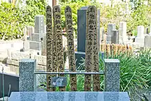
The great Chinese black pine in the garden is over 700 years old.[1] Behind the temple there are two hōkyōintō. The smallest is one of Masako's possible graves. The other is the oldest hōkyōintō in Kamakura and a nationally designated Important Cultural Property.[1] In the temple's small cemetery down the alley in front of the temple's gate rests famous film director Akira Kurosawa.[3]
See also
- For an explanation of terms concerning Japanese Buddhism, Japanese Buddhist art, and Japanese Buddhist temple architecture, see the Glossary of Japanese Buddhism.
Notes
- An'yō-in
- Japanese Wikipedia
- Ozu Yasujiro
References
- Anyoin (in Japanese)
- Article "An'yō-in", Japanese Wikipedia, accessed in April 2008 (in Japanese)
- Ozu Yasujiro Archived 2019-04-14 at the Wayback Machine (in Japanese)