Phalanna

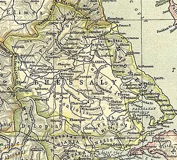
Map showing ancient Thessaly. Phalanna is shown to the upper centre, north of Larissa.
Phalanna (Ancient Greek: Φάλαννα), was a town and polis (city-state)[1] of the Perrhaebi in ancient Thessaly, situated on the left bank of the Peneius, southwest of Gonnus. Strabo says that the Homeric Orthe became the acropolis of Phalanna;[2] but in the lists of Pliny Orthe and Phalanna occur as two distinct towns.[3] Phalanna was said to have derived its name from a daughter of Tyro.[4] It was written Phalannus in Ephorus, and was called Hippia by Hecataeus of Miletus.[4] Phalanna is mentioned by Livy as near Mylae and Gyrton during the Third Macedonian War between the Romans and Perseus of Macedon in 171 BCE.[5]
The site of Phalanna is in the modern community of Damasi (Δαμάσι)[6] near the village of Damasouli (Δαμασούλι).[7]
References
- Mogens Herman Hansen & Thomas Heine Nielsen (2004). "Thessaly and Adjacent Regions". An inventory of archaic and classical poleis. New York: Oxford University Press. pp. 725–726. ISBN 0-19-814099-1.
- Strabo. Geographica. Vol. IX, 5, 19. Page numbers refer to those of Isaac Casaubon's edition.
- Pliny. Naturalis Historia. Vol. 4.9.16.
- Stephanus of Byzantium. Ethnica. Vol. s.v.
- Livy. Ab urbe condita Libri [History of Rome]. Vol. 42.54, 65.
- Richard Talbert, ed. (2000). Barrington Atlas of the Greek and Roman World. Princeton University Press. p. 55, and directory notes accompanying.
- Lund University. Digital Atlas of the Roman Empire.
This article is issued from Wikipedia. The text is licensed under Creative Commons - Attribution - Sharealike. Additional terms may apply for the media files.