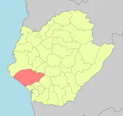
Annan District
Annan
安南區 | |
|---|---|
.jpg.webp) Coastal landscape in Annan District | |
 Annan District in Tainan City | |
| Location | Tainan, Taiwan |
| Area | |
| • Total | 107 km2 (41 sq mi) |
| Population (January 2023) | |
| • Total | 199,502 |
| • Density | 1,900/km2 (4,800/sq mi) |
| Website | www |

Annan District (Chinese: 安南區; pinyin: Ānnán Qū; Wade–Giles: An1-Nan2 Ch'ü1; Pe̍h-ōe-jī: An-Lâm-Khu) is a coastal district located in the west of Tainan, Taiwan.
History
After the handover of Taiwan from Japan to the Republic of China in 1945, Anshun was organized as a rural township of Tainan County. In 1946, the township was incorporated into Tainan City and became Annan District.[1]
Geography
- Area: 107.20 km2
- Population: 199,502 people (January 2023)
Administrative divisions
The district consists of Tunghe, Anshun, Wennan, Zhounan, Zhoubei, Antung, Anx, Dingan, Anqing, Xinshun, Yuandian, Zongtou, Zhangan, Gongqin, Haitung, Haixi, Hainan, Xixin, Gongwen, Yuantung, Yuanxi, Diantung, Dianxi, Yantian, Nanxing, Xuetung, Chengtung, Chengbei, Chengzhong, Chengnan, Chengxi, Jingcao, Shalun, Xiangong, Luer, Sicao, Anhe, Xibei, Xiding, Xiqi, Haidian, Xingfu, Fenghuang, Meihua, Lixiang, Xitung, Yuanzhong, Budai, Guoan, Anfu and Daan Village.[2]
Education
Tourist attractions

- Luerhmen History and Culture Museum
- National Museum of Taiwan History
- Sicao Fortress
- Sicao Wetlands
- Southwest Coast National Scenic Area
- Taijiang National Park
- Taikang Cultural Center
- Zhongzhouliao Night Market
- Guozhai Night Market
Transportation
Annan is the western terminus of National Freeway 8, and is also served by Provincial Highways 17, 17A, 17B (Taijing Boulevard), and 19. The district is also served by Sicao Boulevard, and Chengxi Street.
Notable natives
- Shih Chih-ming, Mayor of Tainan (1989–1997)
See also
References
- "The History of the District Name". Annan District Office, Tainan City. Retrieved 2021-06-05.
- "2018 Local Elections". Archived from the original on 2018-11-29. Retrieved 2018-11-29.
External links
- Official website

- Luerhmen (in Chinese)