Antoine O'Connor
Antoine–François Térence O'Connor was a prominent 18th-century surveyor and cartographer. He was chief engineer of French admiral Charles Henri Hector d'Estaing.[2]

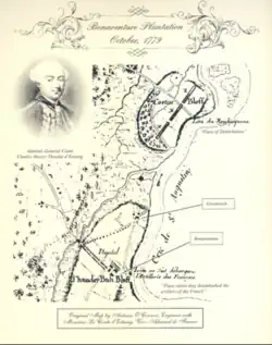
An October 1779 map by O'Connor of the coastline to the east of the Savannah colony, including Bonaventure Plantation[1]
He wrote an account of the 1779 siege of Savannah. Originally titled Journal of the Siege of Savannah, with Some Observations by M. le Comte d'Estaing, it was published in 1974 as part of Muskets, Cannon Balls and Bombs; Nine Narratives of the Siege of Savannah in 1779. d'Estaing provided the document's preface and marginal comments.[3] The document became notable for illustrating the process of building Franco-American cooperations.[1]
O'Connor, who was described as a "highly capable Irish Catholic", was educated at the age of 29 in France's School of Engineers.[4]
References
- Walker, Paul K. (2002). Engineers of Independence: A Documentary History of the Army Engineers in the American Revolution, 1775-1783. University Press of the Pacific. p. 265. ISBN 9781410201737.
- "Ten Great Revolutionary War Maps". The American Revolution Institute. Retrieved 2022-12-05.
- Lynch, Barbara A. (1976). The War at Sea: France and the American Revolution: a Bibliography. Department of the Navy, Naval History Division. p. 25.
- Tucker, Phillip Thomas (2023). Brothers in Liberty: The Forgotten Story of the Free Black Haitians Who Fought for American Independence. Stackpole Books. p. 202. ISBN 9780811770620.
This article is issued from Wikipedia. The text is licensed under Creative Commons - Attribution - Sharealike. Additional terms may apply for the media files.