Anvil Island
Anvil Island is the third-largest of the islands in Howe Sound, British Columbia, Canada, and the northernmost of the major islands in that sound. It is part of West Howe Sound, Electoral Area F within the Sunshine Coast Regional District (SCRD) on the Sunshine Coast.
Native name: Lhaxwm | |
|---|---|
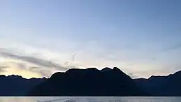
 Anvil Island viewed from the south shortly after sunset. | |
| Geography | |
| Location | Howe Sound |
| Coordinates | 49.530000°N 123.309000°W |
| Area | 9.5 km2 (3.7 sq mi)(Approx.) |
| Coastline | 14 km (8.7 mi)(Approx.) |
| Highest elevation | 765 m (2510 ft) |
| Highest point | Leading Peak |
| Demographics | |
| Population | ~6 (2023) |
It is located northeast of Gambier Island and southwest of Britannia Beach and west of Porteau Cove. The Defence Islands are to its northeast and are Indian Reserves of the Squamish Nation. Daybreak Point Bible Camp, a summer camp, operates south of the island, and some summer homes are located there.
Name origin
The name was conferred on June 14, 1792, by Captain George Vancouver, whose journal for the day reads:
- "The sun shining at this time for a few minutes afforded an island which, from the shape of the mountain that composes it, obtained the name of Anvil Island."[1]
The indigenous Squamish name for the island is Lhaxwm. It was an important place of spiritual training. In mythology, a serpent resided at the peak of the island.[2]
Terrain

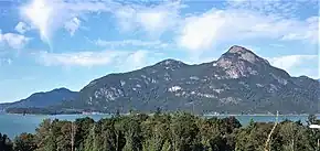
The highest point is Leading Peak (765 meters).
The terrain of Anvil Island is primarily rocky cliffs and steep hills that line the coast. However, at the south side of the island on either side of Irby Point, the southernmost point of the island, there is flatter terrain. Following the Montagu Channel northward on the east side of the island there juts out Fern Point with Fern Bay facing the south and North Bay facing the north. This section is relatively flat with both bays having beaches and Fern Point being lined with cliffs into the water. Following the coast, north of North Bay is Ram Bay marking the end of the relatively flat land on the sound of the island. Domett Point marks the northernmost point of the island, being lined with cliffs and large hills. Heading south along the Ramillies Channel Anvil's coastal terrain continues with substantial cliffs and impassable hills.
Inland from Irby Point, northwards, there is a prominent incline which leads first to a rocky outcropping approximately 400m in elevation, this is the location of the 'white spot' a popular hike on the way to Leading Peak. Before the peak of the island, there are two ridges which hug the lake and Champside Creek. The top of the western ridge is named Nighthawk Peak and has a trail leading from the camp traversing the west side of the island. The eastern ridge is unnamed and unexplored. In between the lake and the peak, there is a saddle which forms a low terrain before rising significantly towards Leading Peak. Leading Peak is surrounded by large cliffs which vary in height from 10-50 metres. Domett Point is made up of similar terrain to the sides of the island, being made up of large rocky hills and steep cliff faces.
People
Anvil Island has a small population living on the island year-round and is populated mostly during the summer.
References
- Vancouver, George Capt. (1798). A Voyage of Discovery to the North Pacific Ocean and Round the World, in which the Coast of North-West America has been carefully Examined and Accurately Surveyed, undertaken by his Majesty’s Command, principally with a View to ascertain the existence of any Navigable Communication between the North Pacific and North Atlantic Oceans and performed in the years 1790, 1791, 1793, 1794 and 1795 in the Discovery Sloop of War and Armed Tender Chatham, under the Command of Captain George Vancouver, in Three Volumes, Vol. I. London: G. G. and J. Robinson. p. 304.
The fun fhining at this time for a few minutes afforded an opportunity of afcertaining the latitude of the eaft point of an ifland which, from the (fhape of the mountain that compofes it, obtained the name of Anvil Island, to be 49°30', its longitude 237° 3'.
- "BC Geographical Names".