Ardabil County
Ardabil County (Persian: شهرستان اردبیل) is in Ardabil province, Iran. Its capital is the city of Ardabil.[3]
Ardabil County
Persian: شهرستان اردبیل | |
|---|---|
County | |
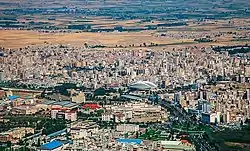 Ardabil skyline | |
 Location of Ardabil County in Ardabil province (center, yellow) | |
 Location of Ardabil province in Iran | |
| Coordinates: 38°17′N 48°19′E[1] | |
| Country | |
| Province | Ardabil |
| Capital | Ardabil |
| Districts | Central, Hir, Samarin |
| Area | |
| • Total | 2,211 km2 (854 sq mi) |
| Elevation | 1,500 m (4,900 ft) |
| Population (2016)[2] | |
| • Total | 605,992 |
| • Density | 270/km2 (710/sq mi) |
| Time zone | UTC+3:30 (IRST) |
| Ardabil County at GEOnet Names Server | |
At the 2006 census, the county's population was 542,930 in 131,950 households.[4] The following census in 2011 counted 564,365 people in 156,242 households, by which time Sareyn District had been separated from the county to form Sareyn County.[5] At the 2016 census, the county's population was 605,992 in 180,975 households.[2]
Administrative divisions
The population history and structural changes of Ardabil County's administrative divisions over three consecutive censuses are shown in the following table. The latest census shows three districts, 10 rural districts, and two cities.[2]
| Administrative Divisions | 2006[4] | 2011[5] | 2016[2] |
|---|---|---|---|
| Central District | 502,186 | 533,495 | 578,237 |
| Arshaq-e Sharqi RD | 5,856 | 4,400 | 3,403 |
| Balghelu RD | 21,368 | 7,297 | 8,054 |
| Gharbi RD | 10,730 | ||
| Kalkharan RD | 13,564 | 9,991 | 10,048 |
| Sardabeh RD | 20,579 | 20,446 | 19,396 |
| Sharqi RD | 17,420 | 8,729 | 7,962 |
| Ardabil (city) | 412,669 | 482,632 | 529,374 |
| Hir District | 23,547 | 21,709 | 19,282 |
| Fuladlui-ye Jonubi RD | 3,148 | 2,619 | 2,021 |
| Fuladlui-ye Shomali RD | 9,263 | 9,423 | 9,341 |
| Hir RD | 8,548 | 7,146 | 5,840 |
| Arallu (city)1 | |||
| Hir (city) | 2,588 | 2,521 | 2,080 |
| Samarin District | 9,161 | 8,471 | |
| Dujaq RD | 4,186 | 3,535 | |
| Gharbi RD | 4,975 | 4,936 | |
| Samarin (city)1 | |||
| Sareyn District2 | 17,197 | ||
| Ab-e Garm RD | 7,844 | ||
| Sabalan RD | 4,875 | ||
| Sareyn (city) | 4,478 | ||
| Total | 542,930 | 564,365 | 605,992 |
| RD: Rural District 1Became a city after the 2016 census[6][7] 2Became a part of Sareyn County | |||
Wikimedia Commons has media related to Ardabil County.
References
- OpenStreetMap contributors (26 March 2023). "Ardabil County" (Map). OpenStreetMap. Retrieved 26 March 2023.
- "Census of the Islamic Republic of Iran, 1395 (2016)". AMAR (in Persian). The Statistical Center of Iran. p. 24. Archived from the original (Excel) on 22 March 2019. Retrieved 19 December 2022.
- Gitashenasi Province Atlas of Iran
اطلس گیتاشناسی استانهای ایران - "Census of the Islamic Republic of Iran, 1385 (2006)". AMAR (in Persian). The Statistical Center of Iran. p. 24. Archived from the original (Excel) on 20 September 2011. Retrieved 25 September 2022.
- "Census of the Islamic Republic of Iran, 1390 (2011)" (Excel). Iran Data Portal (in Persian). The Statistical Center of Iran. p. 24. Retrieved 19 December 2022.
- "Turning Samrin village into a city, trying to turn seven villages into a city". Jamaran News (in Persian). Retrieved 26 March 2023.
- "With the approval of the government board Aralluy and Alni villages became cities". IRIB News (in Persian). Archived from the original on 19 July 2019. Retrieved 26 March 2023.
| Capital | 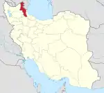 | ||||||||||||||||||||||
|---|---|---|---|---|---|---|---|---|---|---|---|---|---|---|---|---|---|---|---|---|---|---|---|
| Counties and cities |
| ||||||||||||||||||||||
| Landmarks |
| ||||||||||||||||||||||
| Places | |||||||||||||||||||||||
| Capital | |||||||||||||||||||||||||||||||
|---|---|---|---|---|---|---|---|---|---|---|---|---|---|---|---|---|---|---|---|---|---|---|---|---|---|---|---|---|---|---|---|
| Districts |
| ||||||||||||||||||||||||||||||
This article is issued from Wikipedia. The text is licensed under Creative Commons - Attribution - Sharealike. Additional terms may apply for the media files.