Ashland, Kansas
Ashland is a city in and the county seat of Clark County, Kansas, United States.[3] As of the 2020 census, the population of the city was 783.[5]
Ashland, Kansas | |
|---|---|
City and County seat | |
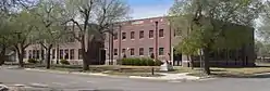
_from_SE_2.JPG.webp) First National Bank building, listed in the National Register of Historic Places[2] | |
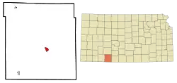 Location within Clark County and Kansas | |
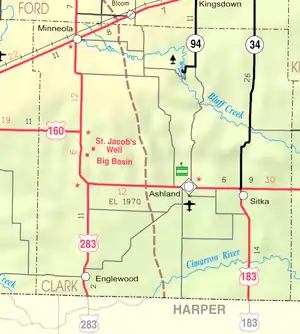 KDOT map of Clark County (legend) | |
| Coordinates: 37°11′12″N 99°46′11″W[3] | |
| Country | United States |
| State | Kansas |
| County | Clark |
| Founded | 1884 |
| Incorporated | 1886 |
| Named for | Ashland, Kentucky |
| Area | |
| • Total | 1.69 sq mi (4.38 km2) |
| • Land | 1.69 sq mi (4.38 km2) |
| • Water | 0.00 sq mi (0.00 km2) |
| Elevation | 1,972 ft (601 m) |
| Population | |
| • Total | 783 |
| • Density | 460/sq mi (180/km2) |
| Time zone | UTC-6 (CST) |
| • Summer (DST) | UTC-5 (CDT) |
| ZIP code | 67831 |
| Area code | 620 |
| FIPS code | 20-02675 |
| GNIS ID | 2393999[3] |
| Website | ashlandks.com |
History
Ashland lies along what was once a military road from Fort Dodge (now Dodge City, Kansas) to the north and Fort Supply in the Indian Territory to the south. In 1870, during the Comanche Campaign against the Native Americans, the Army built two redoubts along the Dodge/Supply trail near the current site of Ashland: the Bear Creek Redoubt, five miles to the north,[6] and the Cimarron Redoubt, nine miles to the south.[7]
Founded in 1884,[8] it was named after the city of Ashland, Kentucky.[9] The first post office in Ashland was established in 1885.[10]
Geography
According to the United States Census Bureau, the city has a total area of 1.68 square miles (4.35 km2), all of it land.[11]
Climate
| Climate data for Ashland, Kansas (1981–2010) | |||||||||||||
|---|---|---|---|---|---|---|---|---|---|---|---|---|---|
| Month | Jan | Feb | Mar | Apr | May | Jun | Jul | Aug | Sep | Oct | Nov | Dec | Year |
| Average high °F (°C) | 47.7 (8.7) |
51.4 (10.8) |
61.6 (16.4) |
70.6 (21.4) |
80.0 (26.7) |
89.7 (32.1) |
95.2 (35.1) |
93.2 (34.0) |
85.5 (29.7) |
73.2 (22.9) |
59.6 (15.3) |
48.5 (9.2) |
71.4 (21.9) |
| Average low °F (°C) | 18.5 (−7.5) |
22.0 (−5.6) |
31.3 (−0.4) |
40.4 (4.7) |
52.9 (11.6) |
63.6 (17.6) |
67.7 (19.8) |
65.8 (18.8) |
56.2 (13.4) |
41.8 (5.4) |
29.3 (−1.5) |
20.1 (−6.6) |
42.5 (5.8) |
| Average precipitation inches (mm) | 0.66 (17) |
0.73 (19) |
1.39 (35) |
1.83 (46) |
3.19 (81) |
3.96 (101) |
2.94 (75) |
2.98 (76) |
1.60 (41) |
1.79 (45) |
0.93 (24) |
1.00 (25) |
23.00 (584) |
| Average snowfall inches (cm) | 2.3 (5.8) |
3.6 (9.1) |
1.8 (4.6) |
0.1 (0.25) |
0.0 (0.0) |
0.0 (0.0) |
0.0 (0.0) |
0.0 (0.0) |
0.0 (0.0) |
0.1 (0.25) |
0.5 (1.3) |
3.2 (8.1) |
11.6 (29) |
| Source: NOAA[12] | |||||||||||||
Demographics
| Census | Pop. | Note | %± |
|---|---|---|---|
| 1890 | 459 | — | |
| 1900 | 493 | 7.4% | |
| 1910 | 910 | 84.6% | |
| 1920 | 1,147 | 26.0% | |
| 1930 | 1,232 | 7.4% | |
| 1940 | 1,186 | −3.7% | |
| 1950 | 1,493 | 25.9% | |
| 1960 | 1,312 | −12.1% | |
| 1970 | 1,244 | −5.2% | |
| 1980 | 1,096 | −11.9% | |
| 1990 | 1,032 | −5.8% | |
| 2000 | 975 | −5.5% | |
| 2010 | 867 | −11.1% | |
| 2020 | 783 | −9.7% | |
| U.S. Decennial Census | |||
In 2000, the median income for a household in the city was $32,721, and the median income for a family was $40,682. Males had a median income of $25,000 versus $20,313 for females. The per capita income for the city was $18,183. About 9.5% of families and 11.6% of the population were below the poverty line, including 19.3% of those under age 18 and 7.9% of those age 65 or over.
2010 census
As of the census[13] of 2010, there were 867 people, 381 households, and 239 families residing in the city. The population density was 516.1 inhabitants per square mile (199.3/km2). There were 465 housing units at an average density of 276.8 per square mile (106.9/km2). The racial makeup of the city was 92.7% White, 0.9% Native American, 0.5% Asian, 0.1% Pacific Islander, 2.3% from other races, and 3.5% from two or more races. Hispanic or Latino of any race were 8.8% of the population.
There were 381 households, of which 27.6% had children under the age of 18 living with them, 49.6% were married couples living together, 9.2% had a female householder with no husband present, 3.9% had a male householder with no wife present, and 37.3% were non-families. 33.9% of all households were made up of individuals, and 17.3% had someone living alone who was 65 years of age or older. The average household size was 2.22 and the average family size was 2.81.
The median age in the city was 44.8 years. 23.9% of residents were under the age of 18; 5.4% were between the ages of 18 and 24; 21.2% were from 25 to 44; 28% were from 45 to 64; and 21.7% were 65 years of age or older. The gender makeup of the city was 48.6% male and 51.4% female.
Arts and culture
- Big Basin Prairie Preserve
- St. Jacob's Well
Education
The community is served by Ashland USD 220 public school district.[14] USD 220 has two schools: Ashland Elementary School and Ashland Junior/Senior High School. The school mascot is the Bluejay and the school colors are royal blue, yellow, and white.
Notable people
- Ronald Johnson, (1935–1998), American poet.
- Wes Santee, (1932–2010), American middle distance runner
References
- "National and State Registers of Historic Places: County: Clark". Kansas Historical Society. Retrieved 2016-04-03.
- "National and State Registers of Historic Places: County: Clark". Kansas Historical Society. Retrieved 2016-04-03.
- U.S. Geological Survey Geographic Names Information System: Ashland, Kansas
- "2019 U.S. Gazetteer Files". United States Census Bureau. Retrieved July 24, 2020.
- "Profile of Ashland, Kansas in 2020". United States Census Bureau. Archived from the original on November 22, 2021. Retrieved November 22, 2021.
- Stein, Martin. National Register of Historic Places Inventory/Nomination: Bear Creek Redoubt. National Park Service, 1976-04-26, 1-2. Accessed 2009-09-09.
- Stein, Martin. National Register of Historic Places Inventory/Nomination: Cimarron Redoubt. National Park Service, 1976-04-26, 1-2. Accessed 2009-09-09.
- "Clark County". Blue Skyways. Kansas State Library. Retrieved June 7, 2014.
- Kansas State Historical Society (1916). Biennial Report of the Board of Directors of the Kansas State Historical Society. Kansas State Printing Plant. pp. 159.
- "Kansas Post Offices, 1828-1961 (archived)". Kansas Historical Society. Archived from the original on October 9, 2013. Retrieved June 6, 2014.
- "US Gazetteer files 2010". United States Census Bureau. Archived from the original on January 25, 2012. Retrieved July 6, 2012.
- "NOWData - NOAA Online Weather Data". National Oceanic and Atmospheric Administration. Retrieved February 7, 2023.
- "U.S. Census website". United States Census Bureau. Retrieved July 6, 2012.
- "USD 220 Ashland". USD 220. Retrieved January 6, 2017.
Further reading
External links
Municipalities and communities of Clark County, Kansas, United States | ||
|---|---|---|
| Cities | 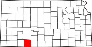 Map of Kansas highlighting Clark County | |
| Unincorporated communities | ||
| Ghost towns | ||
| Townships | ||