Atça
Atça is a neighbourhood of the municipality and district of Sultanhisar, Aydın Province, Turkey.[1] Its population is 7,563 (2022).[2] Before the 2013 reorganisation, it was a town (belde).[3][4]
Atça | |
|---|---|
 | |
 Atça Location in Turkey 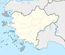 Atça Atça (Turkey Aegean) | |
| Coordinates: 37°53′N 28°13′E | |
| Country | Turkey |
| Province | Aydın |
| District | Sultanhisar |
| Elevation | 84 m (276 ft) |
| Population (2022) | 7,563 |
| Time zone | TRT (UTC+3) |
| Postal code | 09470 |
| Area code | 0256 |
History
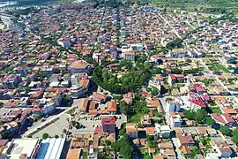
During the Greco-Turkish War (1919–1922), the town was destroyed by fire. It was rebuilt as a circular town, inspired by the Place de l'Étoile in Paris.[5][6]
External links
Wikimedia Commons has media related to Atça.
- Municipality of Atça - Official web site (in Turkish)
See also
References
- Mahalle, Turkey Civil Administration Departments Inventory. Retrieved 12 July 2023.
- "Address-based population registration system (ADNKS) results dated 31 December 2022, Favorite Reports" (XLS). TÜİK. Retrieved 12 July 2023.
- "Law No. 6360". Official Gazette (in Turkish). 6 December 2012.
- "Classification tables of municipalities and their affiliates and local administrative units" (DOC). Official Gazette (in Turkish). 12 September 2010.
- "About Atça". Archived from the original on 5 February 2011.
- Celikyay, Selam. "Evaluatıons On The Planned Urban Development Shapıng Landscape In Atça". Bartın University International Journal of Natural and Applied Sciences: 18-28.
- http://aydinim.net/news.asp?id=3832373038%5B%5D (in Turkish)
This article is issued from Wikipedia. The text is licensed under Creative Commons - Attribution - Sharealike. Additional terms may apply for the media files.