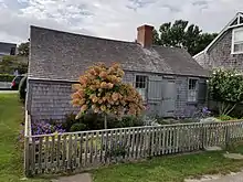
Auld Lang Syne (house)
Auld Lang Syne is one of the oldest houses on the island Nantucket, Massachusetts[1] and is located at 6 Broadway in Siasconset. The oldest part of the house was constructed around 1675[2][3] making it possibly older than the more well-known Jethro Coffin House. Auld Lang Syne was constructed
by Michael [or Micah] Coffin, who employed Native Americans to fish for him while he remained ashore to do the cooking. The house grew from a rectangular structure with a great room and two small chambers to the south. In the eighteenth century it evolved into a T-plan structure with low shed-roof extensions. It was expanded in the eighteenth and nineteenth centuries with warts on the south side, a kitchen at the north side, and a shed.[4]
.jpg.webp)

Some had speculated that the house was moved to the current location from an earlier location at a fishing village in Pedee near Quidnet, but there's no evidence to support this.[5] The house was owned by Captain Henry Coleman and his heirs from the eighteenth century to 1937 when it was acquired by architect Sartain Smith and then his heir Mishi Kamiya and then her sister Matsuko (Dorothy) Suga.[5] In the early 1990s Max Johnson then purchased and restored the house which was then in deteriorating condition and near collapse; Sam Daniel bought the house in 2002.[5]
References
- Robert Gambee, Elizabeth Heard, Nantucket Impressions, (2001), p. 335
- "'Sconset's Early Architecture" https://nha.org/digitalexhibits/sconset02564/timeline/early-architecture.html
- Leslie Linsley, "Living 'rough' in Sconset." Nantucket Today, https://nantuckettodayonline.com/archives/dexioma/
- A Walk Down Broadway A Self-Guided Walking Tour through 'Sconset's Historic Core, p. 21 https://www.nantucketpreservation.org/wp-content/uploads/2015/10/SconsetTour.pdf
- "Is Nantucket's oldest house really in 'Sconset?," NAREB News July 15, 2011 p. 1-14 https://issuu.com/nareb-online/docs/july14/14