Békés County (former)
Békés was an administrative county (comitatus) of the Kingdom of Hungary. Its territory, which was smaller than that of present Békés county, is now in southeastern Hungary. The capital of the county was Gyula.
| Békés County | |
|---|---|
| County of the Kingdom of Hungary (11th century-1541) County of the Eastern Hungarian Kingdom (1541-1566) County of the Kingdom of Hungary (1699-1786, 1790-1853, 1860-1946) | |
.svg.png.webp) Coat of arms
| |
 | |
| Capital | Békés; Gyula (1405-1946) |
| Area | |
| • Coordinates | 46°39′N 21°16′E |
• 1910 | 3,670 km2 (1,420 sq mi) |
| Population | |
• 1910 | 298,710 |
| History | |
| History | |
• Established | 11th century |
• Ottoman conquest | 1566 |
• County recreated | 1699 |
• Merged into Békés-Csanád-Csongrád County | 1 June 1786 |
• County recreated | 26 April 1790 |
• Merged into Békés-Csanád County | 10 January 1853 |
• County recreated | 20 October 1860 |
• Monarchy abolished | 1 February 1946 |
| Today part of | Hungary |
Geography
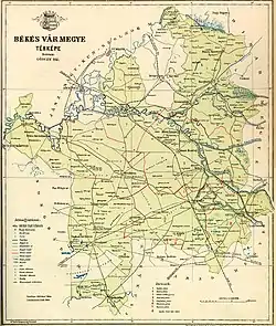
Map of Bekes, 1891.
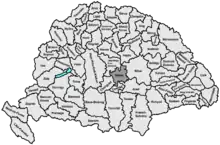
Békés county shared borders with the Hungarian counties Csongrád, Jász-Nagykun-Szolnok, Hajdú, Bihar, Arad and Csanád. The river Körös flowed through the county. Its area was 3,670 km² around 1910.
History
Békés county arose as one of the first comitatus of the Kingdom of Hungary, in the 11th century. In 1950, the territory of Békés county was expanded with:
- the northeastern part of former Csanád-Arad-Torontál county (the Hungarian part of pre-1920 Arad county and the north-eastern part of pre-1920 Csanád county)
- a part of former Bihar county (the area around Sarkad and Okány)
- a part of Jász-Nagykun-Szolnok county (the area around Dévaványa)
Demographics
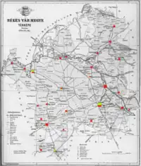
Ethnic map of the county with data of the 1910 census (see the key in the description).
| Census | Total | Hungarian | Slovak | Romanian | German | Other or unknown |
|---|---|---|---|---|---|---|
| 1880[1] | 229,757 | 152,877 (69.84%) | 53,517 (24.45%) | 5,347 (2.44%) | 6,611 (3.02%) | 530 (0.24%) |
| 1890[2] | 258,386 | 188,781 (73.06%) | 56,876 (22.01%) | 6,019 (2.33%) | 6,110 (2.36%) | 600 (0.23%) |
| 1900[3] | 278,731 | 201,619 (72.33%) | 64,467 (23.13%) | 6,069 (2.18%) | 6,191 (2.22%) | 385 (0.14%) |
| 1910[4] | 298,710 | 219,261 (73.40%) | 66,770 (22.35%) | 6,125 (2.05%) | 6,048 (2.02%) | 506 (0.17%) |
| Census | Total | Lutheran | Calvinist | Roman Catholic | Eastern Orthodox | Jewish | Other or unknown |
|---|---|---|---|---|---|---|---|
| 1880 | 229,757 | 82,780 (36.03%) | 82,129 (35.75%) | 50,838 (22.13%) | 7,149 (3.11%) | 6,255 (2.72%) | 606 (0.26%) |
| 1890 | 258,386 | 92,327 (35.73%) | 91,339 (35.35%) | 58,867 (22.78%) | 7,477 (2.89%) | 7,189 (2.78%) | 1,187 (0.46%) |
| 1900 | 278,731 | 98,882 (35.48%) | 95,548 (34.28%) | 66,857 (23.99%) | 7,870 (2.82%) | 7,358 (2.64%) | 2,216 (0.80%) |
| 1910 | 298,710 | 105,724 (35.39%) | 98,596 (33.01%) | 75,738 (25.36%) | 8,374 (2.80%) | 7,444 (2.49%) | 2,834 (0.95%) |
Subdivisions
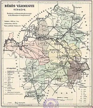
In the early 20th century, the subdivisions of Békés county were:
| Districts (járás) | |
|---|---|
| District | Capital |
| Békés | Békés |
| Békéscsaba | Békéscsaba |
| Gyoma | Gyoma |
| Gyula | Gyula |
| Orosháza | Orosháza |
| Szarvas | Szarvas |
| Szeghalom | Szeghalom |
| Urban districts (rendezett tanácsú város) | |
| Gyula | |
_2.jpg.webp)
Gyula Castle
Notes
- Only linguistic communities > 1% are displayed.
- Only religious communities > 1% are displayed.
References
- "Az 1881. év elején végrehajtott népszámlálás főbb eredményei megyék és községek szerint rendezve, II. kötet (1882)". library.hungaricana.hu. Retrieved 2021-09-28.
- "A Magyar Korona országainak helységnévtára (1892)". library.hungaricana.hu. Retrieved 2021-09-29.
- "A MAGYAR KORONA ORSZÁGAINAK 1900". library.hungaricana.hu. Retrieved 2021-09-29.
- "KlimoTheca :: Könyvtár". Kt.lib.pte.hu. Retrieved 2021-09-29.

This article is issued from Wikipedia. The text is licensed under Creative Commons - Attribution - Sharealike. Additional terms may apply for the media files.