Baarle-Hertog
Baarle-Hertog (Dutch pronunciation: [ˌbaːrlə ˈɦɛrtɔx]; French: Baerle-Duc, pronounced [baʁl(ə)dyk]) is a Flemish municipality of Belgium, much of which consists of a number of small Belgian enclaves fully surrounded by the Netherlands.
Baarle-Hertog | |
|---|---|
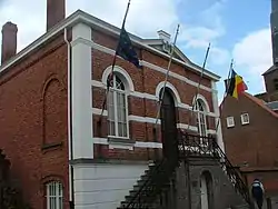 Former town hall | |
 Flag  Coat of arms | |
Location of Baarle-Hertog | |
 Baarle-Hertog Location in Belgium
Location of Baarle-Hertog in the province of Antwerp 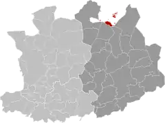 | |
| Coordinates: 51°27′N 04°56′E | |
| Country | |
| Community | Flemish Community |
| Region | Flemish Region |
| Province | Antwerp |
| Arrondissement | Turnhout |
| Government | |
| • Mayor | Frans de Bont (Forum+) |
| • Governing party/ies | N-VA, Forum+ |
| Area | |
| • Total | 7.41 km2 (2.86 sq mi) |
| Population (2020-01-01)[1] | |
| • Total | 2,865 |
| • Density | 390/km2 (1,000/sq mi) |
| Postal codes | 2387 |
| NIS code | 13002 |
| Area codes | 014 |
| Website | Official website |
Parts of Baarle-Hertog are surrounded by the Dutch province of North Brabant, but it is part of the Belgian province of Antwerp. As of 2021, it has a population of 2,935. The total area is 7.48 square kilometres (2.89 square miles).[2]
Geography
Border with Baarle-Nassau
Baarle-Hertog is noted for its complicated borders with Baarle-Nassau, Netherlands.[3]
The border's complexity results from a number of medieval treaties, agreements, land-swaps and sales between the Lords of Breda and the Dukes of Brabant. Generally speaking, predominantly agricultural or built environments became constituents of Brabant and other parts devolved to Breda. These distributions were ratified and clarified as a part of the border settlements agreed under the Treaty of Maastricht in 1843. The tight integration of the European Union and in particular the Schengen Agreement have made many of the practicalities of the situation substantially simpler since the 1990s.
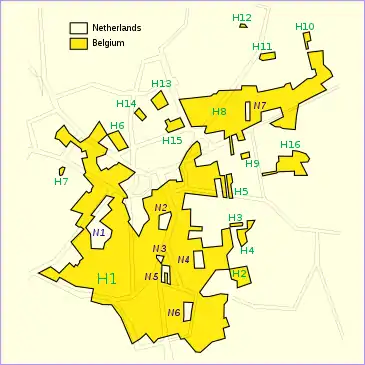
In total, the municipality of Baarle-Hertog consists of 26 separate parcels of land. Four are linked to other Belgian municipalities, from west to east: the Baalbrugse Bemden, a strip of land along the Merkske, Zondereigen-Ginhoven and an area near Weelde-Station. The largest single section, Zondereigen (named after its main hamlet), is located within mainland Belgium on the contiguous Dutch-Belgian border (north of the town of Merksplas). In addition to this, there are 22 Belgian exclaves fully within the Netherlands. There are also seven Dutch enclaves within the Belgian exclaves (i.e., counter-exclaves) that are part of the territory of the Netherlands. Six of these Dutch enclaves are located within the largest Belgian exclave, and a seventh in the second-largest Belgian exclave. An eighth Dutch exclave is located near Ginhoven.
During the First World War, this situation meant that the Imperial German Army could not occupy these parts of Belgium without crossing the Netherlands, which the Dutch government did not allow. Thus, these pieces of Belgium became a place where refugees could safely stay.[4] A clandestine radio transmitter was smuggled in and from there worked with the Belgian resistance. The Dutch government fenced off these areas and controlled access in or out of them, building a church and school for the Belgian people who were effectively stranded within the enclaves.[5] This situation did not exist in the Second World War, as both countries were occupied by Nazi Germany.
Some houses in the town of Baarle-Hertog/Baarle-Nassau are divided between the two countries. At one time, according to Dutch laws, restaurants had to close earlier. For some restaurants on the border, this simply meant that the customers had to move to a table on the Belgian side.[6] In 2020, restrictions due to the COVID-19 pandemic differed between the two countries; for instance, preventing a Belgian citizen living metres away from an open Dutch bar from patronising it.[7]
Many fireworks shops are found in Baarle-Hertog, as Belgian laws controlling the sale of fireworks are more lenient than those of the Netherlands. Many Dutch tourists come to Baarle-Hertog to buy fireworks to celebrate the New Year.
Two villages in the municipality, Zondereigen and Ginhoven, are located in the main territory of Belgium.
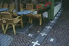 Café in Baarle-Nassau, showing border between Belgium and the Netherlands
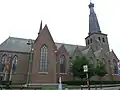 Church of Saint Remigius
Netherlands enclaves
These are all part of Baarle-Nassau municipality.
| Serial no. and local name[8] | Area (ha) | area
acre | Notes |
|---|---|---|---|
| 5.3667 | 13.2615 | Counter-enclave surrounded by Belgian exclave H1, in Baarle-Hertog; contains a mix of dwellings and farmland; boundary of N1 and H1 runs through one building. | |
| 1.3751 | 3.3981 | Counter-enclave surrounded by Belgian exclave H1, in Baarle-Hertog; contains 8 dwellings. | |
| 0.2863 | 0.7075 | Counter-enclave surrounded by Belgian exclave H1, in Baarle-Hertog; boundary of N3 and H1 bisects the loading dock of a liquor store. | |
| 1.2324 | 3.0454 | Counter-enclave surrounded by Belgian exclave H1, in Baarle-Hertog; boundary of N4 and H1 runs through a warehouse, with vacant Dutch land to the rear of the warehouse. | |
| 1.9212 | 4.7475 | Counter-enclave surrounded by Belgian exclave H1, in Baarle-Hertog; boundary of N5 and H1 runs through a furniture showroom, a shed and a barn. | |
| 1.4527 | 3.5898 | Counter-enclave surrounded by Belgian exclave H1, in Baarle-Hertog; consists of farmland with two buildings. | |
| 0.5812 | 1.4363 | Counter-enclave surrounded by Belgian Oordeel exclave H8, in Baarle-Hertog; occupies part of a field. | |
| 2.8528 | 7.0496 | Farmland enclave situated within Zondereigen, Belgium, less than 50 meters south of the Dutch border. | |
Belgian enclaves
These are all part of Baarle-Hertog municipality, and are surrounded by Baarle-Nassau municipality (Netherlands).
| Serial no. and local name[8] | Area (ha) | area
acre | Notes |
|---|---|---|---|
| 153.6448 | 379.6717 | Forms a quadripoint with enclave H2; largest Belgian exclave; encompasses six Dutch enclaves; consists of dwellings for the most part, with outlying farmland and an industrial area; boundary runs through numerous buildings; contains a portion of the former Turnhout-Tilburg rail line, now a cycle path. | |
| 2.4116 | 5.9594 | Consists of farmland with a single point of connection (quadripoint) between enclaves H1 and H2 in the middle of a corn field. | |
| 0.3428 | 0.8471 | Occupies part of a field; boundary runs through a shed in one instance. | |
| 1.476 | 3.6474 | Consists of farmland; boundary runs through a house and three sheds. | |
| 0.9245 | 2.2846 | Consists of farmland with a dwelling. | |
| 1.7461 | 4.3148 | Mixed land usage; boundary runs through a warehouse/factory. | |
| 0.2469 | 0.6102 | Boundary runs through two dwellings, including the middle of one front door (giving it two house numbers: Loveren 2, Baarle-Hertog / Loveren 19, Baarle-Nassau). | |
| 41.8781 | 103.485 | Second-largest Belgian exclave, contains a mix of dwellings and farmland; boundary runs through a barn, a dwelling and two businesses. | |
| 0.4005 | 0.9897 | Boundary runs through a printing factory/warehouse in an industrial area. | |
| 0.65 | 1.6063 | Consists of farmland. | |
| 0.93 | 2.2982 | Consists of farmland. | |
| 0.2822 | 0.6974 | Consists of farmland. | |
| 1.5346 | 3.7922 | Boundary runs through about 20 dwellings. | |
| 0.7193 | 1.7774 | Boundary runs through about 13 dwellings. | |
| 1.7211 | 4.2531 | Boundary runs through about 16 dwellings. | |
| 4.4252 | 10.9352 | Boundary runs through a house and three sheds; inside one of the sheds, the linear boundary changes direction three times | |
| 14.9248 | 36.8807 | Rural area containing a portion of the former Turnhout-Tilburg rail line, now a cycle path. | |
| 2.9247 | 7.2273 | Consists of farmland. | |
| 0.6851 | 1.693 | Consists of several ponds and a field. | |
| 1.1681 | 2.8865 | Consists of farmland. | |
| 1.1845 | 2.9271 | Consists of farmland. | |
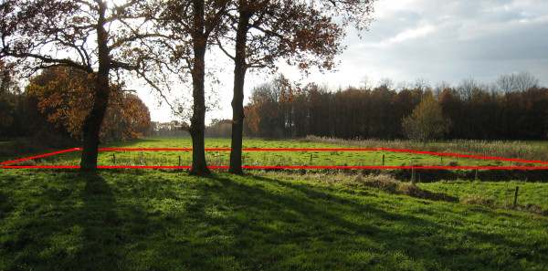
| 0.2632 | 0.6504 | South of the village of Ulicoten; occupies part of a field; nationality was contested from the 1830s until 1995 (remained unallocated to either country in boundary treaty of 26 April 1974) | |
Climate
| Climate data for Baarle-Hertog (1991−2020 normals) | |||||||||||||
|---|---|---|---|---|---|---|---|---|---|---|---|---|---|
| Month | Jan | Feb | Mar | Apr | May | Jun | Jul | Aug | Sep | Oct | Nov | Dec | Year |
| Average high °C (°F) | 6.3 (43.3) |
7.4 (45.3) |
11.0 (51.8) |
15.4 (59.7) |
18.9 (66.0) |
21.6 (70.9) |
23.6 (74.5) |
23.4 (74.1) |
19.8 (67.6) |
15.1 (59.2) |
10.1 (50.2) |
6.7 (44.1) |
14.9 (58.8) |
| Daily mean °C (°F) | 3.6 (38.5) |
4.0 (39.2) |
6.8 (44.2) |
10.1 (50.2) |
13.8 (56.8) |
16.7 (62.1) |
18.7 (65.7) |
18.3 (64.9) |
15.1 (59.2) |
11.2 (52.2) |
7.1 (44.8) |
4.2 (39.6) |
10.8 (51.4) |
| Average low °C (°F) | 0.9 (33.6) |
0.8 (33.4) |
2.6 (36.7) |
4.8 (40.6) |
8.7 (47.7) |
11.8 (53.2) |
13.8 (56.8) |
13.2 (55.8) |
10.3 (50.5) |
7.3 (45.1) |
4.1 (39.4) |
1.6 (34.9) |
6.7 (44.1) |
| Average precipitation mm (inches) | 75.8 (2.98) |
69.9 (2.75) |
59.3 (2.33) |
45.3 (1.78) |
62.3 (2.45) |
76.1 (3.00) |
84.5 (3.33) |
83.2 (3.28) |
71.7 (2.82) |
73.9 (2.91) |
83.6 (3.29) |
96.6 (3.80) |
882.2 (34.73) |
| Average precipitation days (≥ 1.0 mm) | 12.9 | 12.0 | 10.8 | 8.9 | 9.9 | 10.3 | 11.3 | 11.0 | 10.4 | 11.2 | 13.2 | 14.7 | 136.6 |
| Mean monthly sunshine hours | 63 | 81 | 136 | 190 | 217 | 215 | 220 | 205 | 162 | 117 | 69 | 53 | 1,726 |
| Source: Royal Meteorological Institute[9] | |||||||||||||
Education
Baarle-Hertog has two elementary schools: De Vlinder and De Horizon.[10]
It has a joint library with Baarle-Nassau with Belgian and Dutch staff.[11]
Notable inhabitants
- Petrus Christus, 15th century painter
See also
- Büsingen am Hochrhein, an exclave of Germany surrounded by Switzerland
- Campione d'Italia, an exclave of Italy surrounded by Switzerland
- Llívia, an exclave of Spain surrounded by France
- India–Bangladesh enclaves, 173 former enclaves (not including counter-enclaves)
- The City & The City, a novel about two fictional co-existing city states.
References
- "Bevolking per gemeente op 1 januari 2020". Statbel.
- "Bevolking per statistische sector - Sector 13002". Statistics Belgium. Retrieved 9 May 2022.
- González, Diego (January 17, 2010). "Una cervecería en dos países" [A bar in Two Countries]. Fronteras (in Spanish).
- Jacobs, Frank (14 November 2011). "An Apology of Enclaves". New York Times. Archived from the original on 24 March 2022.
- "Enclavegeschiedenis van Baarle", Wikipedia (in Dutch), 2022-11-15, retrieved 2022-11-26
- "The Curious Case of Baarle-Nassau and Baarle-Hertog". Amusingplanet.com. 2012-11-06. Retrieved 2014-08-01.
- "Coronavirus: Dining for some, whining for others in border town Baarle". The Times. 2020-06-05. Retrieved 2020-06-05.
- Whyte, Brendan (2004). "En Territoire Belge et à Quarante Centimètres de la Frontière" An historical and documentary study of the Belgian and Dutch enclaves of Baarle-Hertog and Baarle-Nassau. The University of Melbourne, School of Anthropology, Geography and Environmental Studies. ISBN 0-7340-3032-0.
- "Luchttemperatuur en neerslag Referentieperiode: 1991-2020" (PDF) (in Dutch). Royal Meteorological Institute. Retrieved July 7, 2022.
- "scholen Archived 2018-11-24 at the Wayback Machine." Baarle-Hertog. Retrieved on January 6, 2017.
- "bibliotheek Archived 2018-11-24 at the Wayback Machine." Baarle-Hertog. Retrieved on January 6, 2017.
External links
- Official Web site Baarle-Hertog (in Dutch)
- Official Web site Baarle-Nassau (in Dutch)
- The Baarle Enclaves outlined with Maps
- Open Topo Arcgis map
- Barry Smith's Baarle Site (with maps)
- Photos from Baarle-Nassau/Hertog
- Jan S. Krogh's Geosite about the Baarles
- Photograph of H-22, the smallest enclave of B.-Hertog at 51°26'54"N 4°50'10"E
- New York Times, Frugal Traveler Blog, August 2008 (Matt Gross) – see video of Baarle-Hartog in middle of page
- 'En Territoire Belge et a quarante centimetres de la frontiere' - English-language PhD thesis on the historical geography of Baarle's enclaves, including photos and detailed maps
For main division of Zondereigen | ||||||||||||||||
|---|---|---|---|---|---|---|---|---|---|---|---|---|---|---|---|---|
| ||||||||||||||||
