Baix Empordà
Baix Empordà (pronounced [ˈbaʒ əmpuɾˈða]; English: Lower Empordà, Spanish: Bajo Ampurdán) is a comarca (county) in the Girona region, Catalonia, in Spain. It is one of the two comarques into which Empordà was divided in the comarcal division of 1936, the other one being Alt Empordà. It is popularly known as L'Empordanet ("the Little Empordà"). The capital is La Bisbal d'Empordà.
Baix Empordà | |
|---|---|
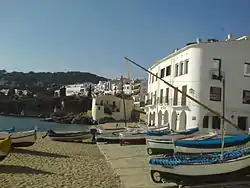 Platja del Port Bo, Calella de Palafrugell | |
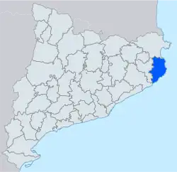 Map of Catalonia, with Baix Empordà shown in solid blue. Comarca boundaries are shown in grey. | |
| Country | |
| Autonomous community | |
| Region | Comarques Gironines |
| Province | Girona |
| Capital | La Bisbal d'Empordà |
| Municipalities | List
|
| Area | |
| • Total | 701.8 km2 (271.0 sq mi) |
| Population (2014) | |
| • Total | 132,886 |
| • Density | 190/km2 (490/sq mi) |
| Demonym | Baixempordanès |
| Time zone | UTC+1 (CET) |
| • Summer (DST) | UTC+2 (CEST) |
| Largest municipality | Palafrugell |
Geography
Extent
Baix Empordà is the southern portion of the historical region of Empordà. It includes the municipalities between the Montgrí Massif, just north of the river Ter, and the Aro valley, in the south. It measure some 43 kilometres (27 mi) from north to south, and 28 kilometres (17 mi) from east to west, with a total area of 700.5 square kilometres (270.5 sq mi). It borders Alt Empordà to the north, Gironès and Selva to the west and the Mediterranean Sea to the east.[1][2]
The Mediterranean coast of the Baix Empordia is part of the Costa Brava, and is a major tourist destination, including resorts such as Sant Feliu de Guíxols, s'Agaro, Platja d'Aro, Sant Antoni de Calonge, Palamós, La Fosca, Calella de Palafrugell, Llafranc, Tamariu, Fornells de Mar and l'Estartit.[3]
The capital of Baix Empordia is La Bisbal d'Empordà, which is some 15 kilometres (9.3 mi) from the coast, but several of the comarca's coastal municipalities have significantly larger populations, most notably Palafrugell, Sant Feliu de Guíxols and Palamós. There are 37 municipalities within the comarca.[4]
Municipalities
| Municipality[4] | Population(2014)[4] | Areakm2[4] |
|---|---|---|
| Albons | 727 | 11.1 |
| Begur | 3,994 | 20.7 |
| Bellcaire d'Empordà | 650 | 12.6 |
| La Bisbal d'Empordà | 10,761 | 20.6 |
| Calonge | 10,541 | 33.6 |
| Castell-Platja d'Aro | 10,721 | 21.8 |
| Colomers | 195 | 4.4 |
| Corçà | 1,257 | 16.3 |
| Cruïlles, Monells i Sant Sadurní de l'Heura | 1,284 | 99.8 |
| Foixà | 320 | 18.8 |
| Fontanilles | 160 | 9.3 |
| Forallac | 1,729 | 50.6 |
| Garrigoles | 159 | 9.4 |
| Gualta | 362 | 9.0 |
| Jafre | 396 | 6.6 |
| Mont-ras | 1,739 | 12.3 |
| Palafrugell | 22,763 | 26.9 |
| Palamós | 17,805 | 14.0 |
| Palau-sator | 305 | 12.4 |
| Pals | 2,533 | 25.8 |
| Parlavà | 410 | 6.2 |
| La Pera | 467 | 11.5 |
| Regencós | 291 | 6.3 |
| Rupià | 246 | 5.3 |
| Sant Feliu de Guíxols | 21,810 | 16.2 |
| Santa Cristina d'Aro | 5,194 | 67.6 |
| Serra de Daró | 211 | 7.9 |
| La Tallada d'Empordà | 454 | 16.6 |
| Torrent | 170 | 8.0 |
| Torroella de Montgrí | 11,381 | 65.9 |
| Ullà | 1,053 | 7.3 |
| Ullastret | 289 | 11.1 |
| Ultramort | 204 | 4.4 |
| Vall-llobrega | 901 | 5.4 |
| Verges | 1,195 | 9.7 |
| Vilopriu | 209 | 16.4 |
| • Total: 36 | 132,886 | 701.8 |
References
- Empordà Costa Brava - Nord (Map). 1:30,000. Editorial PIOLET i Consell Comarcal del Baix Empordà. March 2012.
- Empordà Costa Brava - Sud (Map). 1:30,000. Editorial PIOLET i Consell Comarcal del Baix Empordà. March 2012.
- "Costa Brava – Catalonia" (PDF). Government of Catalonia, Ministry of Innovation, Universities and Enterprise. gencat.cat. Archived from the original (PDF) on 7 November 2011. Retrieved 22 January 2012.
- "El municipi en xifres". Institut d'Estadística de Catalunya. Retrieved 2015-05-25.
External links
- Official comarcal web site (in Catalan)
- Tourist comarcal web site
- Miscellaneous related information on the web site of the Generalitat de Catalunya (in Catalan)
Places adjacent to Baix Empordà | ||||||||||||||||
|---|---|---|---|---|---|---|---|---|---|---|---|---|---|---|---|---|
| ||||||||||||||||