Bandarawela
Bandarawela (Sinhala : බණ්ඩාරවෙල, pronounced [ˈbandarawela]; Tamil: பண்டாரவெல) is the second largest town in the Badulla District which is 28 km (17 mi) away from Badulla. Bandarawela is 200 km (120 mi) away from Colombo and about 125 km (78 mi) away from Kandy, the two largest cities of Sri Lanka. Thanks to its higher altitude, compared to surrounding locations, Bandarawela has milder weather conditions throughout the year making it a tourist destination for locals. Bandarawela is within hours reach of surrounding towns and cities by both road and rail. The town is influenced by its colonial history and rests among dense, lush forestation occupying a niche among visitors as a base for tourism.
Bandarawela
බණ්ඩාරවෙල பண்டாரவெல | |
|---|---|
.jpg.webp) Countryside scenery around Bandarawela | |
 Bandarawela Map of Badulla District showing the location of Bandarawela. | |
| Coordinates: 6°50′0″N 80°59′0″E | |
| Country | Sri Lanka |
| Province | Uva Province |
| District | Badulla District |
| Elevation | 1,292 m (4,239 ft) |
| Highest elevation (Nayabedda Peak) | 1,943 m (6,375 ft) |
| Lowest elevation | 950 m (3,120 ft) |
| Population | |
| • Total | 32,000 (2,021)(Municipal council area)[1] |
| • Density | 968/km2 (2,510/sq mi) |
| Time zone | UTC+5:30 (Sri Lanka Standard Time Zone) |
| Website | |
Politics
The town is governed by a municipal council and headed by a mayor. The council is elected by popular vote and has nine members. There were 16,673 registered voters in the 2011 local authorities elections.[2] The area outside the municipality is governed by the "Pradeshiya Saba" which is similar to the urban council. The Pradeshiya Saba is elected by popular vote and has 10 members. In the 2006 local authorities election there were 37,972 registered voters.[3]
Heritage
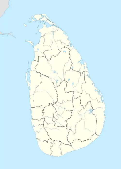
The ancient Dhowa Buddhist rock temple is one of the well-known heritage sites in this region. Other historic areas of interest include the Roman Catholic St. Anthony's Church and a local Methodist church.
The ancient Dhowa Rock Temple was founded by King Walagamba in the first century B.C.E. (1 B.C.E.) and is located beside Badulla-Bandarawela highway, 6 km (3.7 mi) from Bandarawela. The temple contains a 12 m (39 ft)-high Buddha image sculpted from rock and paintings depicting Jataka stories belonging to the Kandyan era.
Geography and climate
Bandarawela is located at a high altitude and surrounded by a large number of mountains in Uva and the Central Province.The highest Mountain in the local area is Nayabedda peak, which lies 6,375 ft (1,943 m)above mean sea [4]
According to the local climatic zone classifications, Bandarawela is classified under Up Country Intermediate Zone (UCIZ) which is spread over the Badulla and Monaragala Districts. The average elevation above sea level at Bandarawela is 4,242 ft (1,293 m).The elevation of Bandarawela ranges between3,110 ft (950 m) and 6,375 ft (1,943 m),[5] the annual average rainfall is 1,652 mm (65.0 in) and the monthly average temperature is between 19 °C (66 °F) (in January) and 21 °C (70 °F) (in April and May). The average annual temperature in Bandarawela is 20 °C (68 °F).[6] The Bandarawela area consists mainly of red yellow Podzolic soil, which is strongly acidic and favourable for tea plantations.The Köppen-Geiger climate classification system classifies its climate as Tropical monsoon (Am)[7] bordering with a subtropical highland (Cfb) climate at Haputale .[8][9]
| Climate data for Bandarawela | |||||||||||||
|---|---|---|---|---|---|---|---|---|---|---|---|---|---|
| Month | Jan | Feb | Mar | Apr | May | Jun | Jul | Aug | Sep | Oct | Nov | Dec | Year |
| Record high °C (°F) | 30.81 (87.46) |
32.87 (91.17) |
33.89 (93.00) |
32.87 (91.17) |
31.84 (89.31) |
31.84 (89.31) |
31.84 (89.31) |
31.84 (89.31) |
32.87 (91.17) |
29.79 (85.62) |
31.84 (89.31) |
29.79 (85.62) |
33.89 (93.00) |
| Average high °C (°F) | 24 (75) |
25 (77) |
26 (79) |
26 (79) |
25 (77) |
23 (73) |
22 (72) |
23 (73) |
23 (73) |
24 (75) |
24 (75) |
23 (73) |
24 (75) |
| Daily mean °C (°F) | 19 (66) |
19.5 (67.1) |
20 (68) |
21 (70) |
21 (70) |
20.5 (68.9) |
19.5 (67.1) |
20 (68) |
20 (68) |
20 (68) |
20 (68) |
19.5 (67.1) |
20.0 (68.0) |
| Average low °C (°F) | 14 (57) |
14 (57) |
14 (57) |
16 (61) |
17 (63) |
18 (64) |
17 (63) |
17 (63) |
17 (63) |
16 (61) |
16 (61) |
15 (59) |
16 (61) |
| Record low °C (°F) | 8.22 (46.80) |
9.24 (48.63) |
12.33 (54.19) |
12.33 (54.19) |
11.3 (52.3) |
11.3 (52.3) |
11.3 (52.3) |
12.33 (54.19) |
10.27 (50.49) |
10.27 (50.49) |
10.27 (50.49) |
9.24 (48.63) |
8.22 (46.80) |
| Average precipitation mm (inches) | 113 (4.4) |
81 (3.2) |
99 (3.9) |
192 (7.6) |
121 (4.8) |
50 (2.0) |
47 (1.9) |
62 (2.4) |
101 (4.0) |
272 (10.7) |
315 (12.4) |
199 (7.8) |
1,652 (65.1) |
| Average rainy days | 11 | 10 | 10 | 16 | 13 | 7 | 6 | 7 | 10 | 16 | 19 | 16 | 141 |
| Source 1: https://www.noaa.gov/ (Average temperatures as mentioned in top google results)[10] | |||||||||||||
| Source 2: https://en.climate-data.org(Precipitation,humidity)[11][12] | |||||||||||||
Demography
Bandarawela is a Sinhala majority town. There are sizable communities belonging to other ethnic groups such as Indian Tamils, Sri Lanka Moors and Sri Lanka Tamils.
| Ethnicity | Population[13] | % of total |
|---|---|---|
| Sinhalese | 17368 | 72.6 |
| Sri Lankan Tamils | 3145 | 13.1 |
| Sri Lankan Moors | 2,488 | 10.4 |
| Indian Tamils | 923 | 3.9 |
| Total | 23,924 | 100 |
Religion
The Main religions in Bandarawela are Buddhism,Hinduism,Islam and Catholicism
| Religions | |||
|---|---|---|---|
| Buddhism | 26932 | (76.11%) | |
| Hinduism | 3583 | (10.13%) | |
| Islam | 3288 | (9.29%) | |
| Roman Catholic | 942 | (2.66%) | |
| Other Christian | 640 | (1.81%) | |
.jpg.webp)
Religion in Bandarawela [13]
Economy
Locals depend primarily upon agriculture and livestock farming to make a living.[14] Many people are directly involved in vegetable cultivation and some work as laborers in tea estates, mainly Indian Tamils. There are a large number of tea plantations managed by both private and government run businesses that produce good quality tea for the world market.

Many types of vegetables are grown in this area throughout the year, such as leek, carrot, beet root, cauliflower and cabbage.. The mean monthly income in Badulla district was 66,413LKR in 2019, slightly lower than the national average.[15]
Tourism is a major source of income in Bandarawela which boasts many holiday resorts, cottages and hotels.
Education
During World War II, many schools in Colombo were temporarily moved to Bandarawela such as Royal College, St. Thomas' College and Visakha Vidyalaya.[16][17] These schools relocated to Bandarawela due to the fear caused by the Japanese bombs. Some schools in the area include Bandarawela Central college, Dharmapala Vidyalaya, Visakha Vidyalaya, Tamil Central College, Little Flower Convent and St. Joseph's College. These schools are governed by the central government of Sri Lanka. There are also two private schools in the area. S. Thomas' College, Bandarawela is the leading private school and the only boys' school in Bandarawela.
Tourism
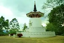
- Views of Bandarawela can be seen from Porawagala.[18]
- Ravana Falls (25 m (82 ft) in height) and Diyaluma Falls (191 m (627 ft) in height) are notable waterfalls in this region. Rawana Ella is situated in Ella near the Ella-Wellawaya main road(A23) and Diyaluma is situated near the village of Koslanda, on the Colombo-Batticaloa highway.
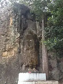
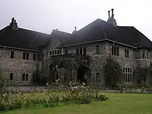
- Adisham Bungalow, Bandarawela Hotel and Lipton's Seat are a few other historic places in the local area.
- Poonagala, Ampittiakande,Uva highlands,Dambetanne Liyangahawela and Halpe are some notable tea estates in the area.
See also
References
- "Bandarawela Municipal Council | Cities". SoSLC.
- "Department of election". slelections.gov.lk. 2006. Archived from the original on 10 December 2009. Retrieved 7 June 2009.
- "Department of election". slelections.gov.lk. 2006. Archived from the original on 5 August 2012. Retrieved 24 June 2009.
- level.https://en-us.topographic-map.com/map-m1glz4/Bandarawela/
- "Bandarawela topographic map, elevation, terrain".
- "Climate & Weather Averages in Bandarawela, Sri Lanka". www.timeanddate.com.
- "Bandarawela climate: Temperature Bandarawela & Weather By Month". en.climate-data.org.
- "https://en.climate-data.org/asia/sri-lanka/uva/bandarawela-717607/"/>
- "Weather for Bandarawela, Badulla District, LK".
- "Average Monthly Temperatures(accesible only via direct google search)". NOAA. Retrieved 7 July 2023.
- "precipitation and humidity". climate-data.org. Retrieved 7 July 2023.
- "Record high and low temperatures". tcktcktck.org. Retrieved 7 July 2023.
- "Bandarawela Municipal Council | Cities".
- Badulla District
- Household Income and Expenditure Survey – 2019 Final Result
- "About".
- "Our History".
- "Porawagala Viewpoint – Bandarawela".
External links
| National capitals# |
| |
|---|---|---|
| Municipal councils | ||
| Urban councils |
| |
Note: * also a Provincial capital, # also a Municipal council | ||