Bay of Bangkok
The Bay of Bangkok (Thai: อ่าวกรุงเทพ, RTGS: Ao Krung Thep, Thai pronunciation: [ʔàːw kruŋ tʰêːp]), also known as the Bight of Bangkok, is the northernmost part of the Gulf of Thailand, roughly extending from Hua Hin District to the west and Sattahip District to the east. Three of the major rivers of central Thailand empty into the bay - the Chao Phraya and its distributary Tha Chin, the Mae Klong and the Bang Pakong River. The bay forms the coast of 8 provinces, them being clockwise: Prachuap Khiri Khan, Phetchaburi, Samut Songkhram, Samut Sakhon, Bangkok, Samut Prakan, Chachoengsao, and Chonburi.
| Bay of Bangkok | |
|---|---|
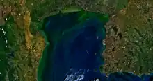
 Map of the Bay of Bangkok | |
| Location | Thailand |
| Coordinates | 13°04′N 100°30′E |
| Type | Bay |
| Native name | อ่าวกรุงเทพ (Thai) |
| Primary inflows | Gulf of Thailand |
| Max. length | 100 km (62 mi) |
| Max. width | 100 km (62 mi) |
| Surface area | 8,640 km2 (3,340 sq mi) |
There are some islands off the eastern shores of the bay, like Ko Sichang, Ko Lan and Ko Phai.[1]
Environment
The water quality of the Bay of Bangkok is rated as "very poor" by the Pollution Control Department.[2]: 54
References
- Hydrographic Service of the Royal Thai Navy, Chart 142
- Thailand State of Pollution Report 2015 (PDF). Bangkok: Pollution Control Department, Ministry of Natural Resources and Environment (Thailand). 2016. ISBN 978-616-316-327-1. Archived from the original (PDF) on 5 September 2017. Retrieved 5 September 2017.