Manaoag
Manaoag, officially the Municipality of Manaoag (Tagalog: [mɐˈnaʊɐg]; Pangasinan: Baley na Manaoag; Ilocano: Ili ti Manaoag; Tagalog: Bayan ng Manaoag), is a 1st class municipality in the province of Pangasinan, Philippines. According to the 2020 census, it has a population of 76,045 people.[3]
Manaoag | |
|---|---|
| Municipality of Manaoag | |
.jpg.webp) | |
 Flag  Seal | |
| Nickname: Pilgrimage town | |
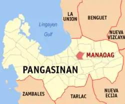 Map of Pangasinan with Manaoag highlighted | |
OpenStreetMap | |
.svg.png.webp) Manaoag Location within the Philippines | |
| Coordinates: 16°02′38″N 120°29′08″E | |
| Country | Philippines |
| Region | Ilocos Region |
| Province | Pangasinan |
| District | 4th district |
| Founded | October 7, 1600 |
| Barangays | 26 (see Barangays) |
| Government | |
| • Type | Sangguniang Bayan |
| • Mayor | Jeremy Agerico B. Rosario |
| • Vice Mayor | Kim Mikael D. Amador |
| • Representative | Christopher P. de Venecia |
| • Electorate | 47,571 voters (2022) |
| Area | |
| • Total | 55.95 km2 (21.60 sq mi) |
| Elevation | 22 m (72 ft) |
| Highest elevation | 64 m (210 ft) |
| Lowest elevation | 6 m (20 ft) |
| Population (2020 census)[3] | |
| • Total | 76,045 |
| • Density | 1,400/km2 (3,500/sq mi) |
| • Households | 17,659 |
| Economy | |
| • Income class | 1st municipal income class |
| • Poverty incidence | 9.37 |
| • Revenue | ₱ 217.1 million (2020) |
| • Assets | ₱ 518 million (2020) |
| • Expenditure | ₱ 214.9 million (2020) |
| • Liabilities | ₱ 45.51 million (2020) |
| Service provider | |
| • Electricity | Dagupan Electric Corporation (DECORP) |
| Time zone | UTC+8 (PST) |
| ZIP code | 2430 |
| PSGC | |
| IDD : area code | +63 (0)75 |
| Native languages | Pangasinan Ilocano Tagalog |
| Website | www |
Etymology
Manaoag came from the Pangasinan word "Mantaoag" which means "to call".
History
Manaoag as a settlement was used to be part of present-day San Jacinto in the early 1600s. Later, the Augustinians established a mission as Mission of Sta. Monica, while Dominicans also served the area.[5]
In 1972, Republic Act No. 6485 was issued wherein twenty barrios were organized as a separate municipality and the province's newest, named Laoac; however, it took long before the establishment was formalized in 1980.[6][7]
Geography
Manaoag is bordered by Pozorrubio in the north, Urdaneta City and Mapandan in the south, Laoac in the east, and San Jacinto in the west.
Manaoag is 33 kilometres (21 mi) from Lingayen and 201 kilometres (125 mi) from Manila.
Barangays
Manaoag is politically subdivided into 26 barangays. Each barangay consists of puroks and some have sitios.
- Babasit
- Baguinay
- Baritao
- Bisal
- Bucao
- Cabanbanan
- Calaocan
- Inamotan
- Lelemaan
- Licsi
- Lipit Norte
- Lipit Sur
- Matulong
- Mermer
- Nalsian
- Oraan East
- Oraan West
- Pantal
- Pao
- Parian
- Poblacion
- Pugaro
- San Ramon
- Santa Ines
- Sapang
- Tebuel
Climate
| Climate data for Manaoag, Pangasinan | |||||||||||||
|---|---|---|---|---|---|---|---|---|---|---|---|---|---|
| Month | Jan | Feb | Mar | Apr | May | Jun | Jul | Aug | Sep | Oct | Nov | Dec | Year |
| Average high °C (°F) | 29 (84) |
29 (84) |
30 (86) |
32 (90) |
33 (91) |
33 (91) |
33 (91) |
33 (91) |
33 (91) |
32 (90) |
31 (88) |
29 (84) |
31 (88) |
| Average low °C (°F) | 21 (70) |
21 (70) |
22 (72) |
23 (73) |
24 (75) |
24 (75) |
24 (75) |
24 (75) |
23 (73) |
23 (73) |
22 (72) |
21 (70) |
23 (73) |
| Average precipitation mm (inches) | 127.5 (5.02) |
115.8 (4.56) |
129.7 (5.11) |
141.1 (5.56) |
248.2 (9.77) |
165 (6.5) |
185.3 (7.30) |
161.9 (6.37) |
221.4 (8.72) |
299.5 (11.79) |
199 (7.8) |
188.7 (7.43) |
2,183.1 (85.93) |
| Average rainy days | 17 | 17 | 17 | 15 | 20 | 19 | 19 | 20 | 21 | 20 | 17 | 19 | 221 |
| Source: World Weather Online[8] | |||||||||||||
Demographics
| Year | Pop. | ±% p.a. |
|---|---|---|
| 1903 | 16,793 | — |
| 1918 | 22,279 | +1.90% |
| 1939 | 29,030 | +1.27% |
| 1948 | 34,304 | +1.87% |
| 1960 | 41,164 | +1.53% |
| 1970 | 48,091 | +1.57% |
| 1975 | 48,450 | +0.15% |
| 1980 | 36,742 | −5.38% |
| 1990 | 45,339 | +2.13% |
| 1995 | 49,705 | +1.74% |
| 2000 | 54,743 | +2.09% |
| 2007 | 62,684 | +1.89% |
| 2010 | 64,578 | +1.09% |
| 2015 | 69,497 | +1.41% |
| 2020 | 76,045 | +1.79% |
| Source: Philippine Statistics Authority[9][10][11][12] | ||
Economy
Government
Local government
Manaoag, belonging to the fourth congressional district of the province of Pangasinan, is governed by a mayor designated as its local chief executive and by a municipal council as its legislative body in accordance with the Local Government Code. The mayor, vice mayor, and the councilors are elected directly by the people through an election which is being held every three years.
Elected officials
| Position | Name |
|---|---|
| Congressman | Christopher Vera Perez de Venecia |
| Mayor | Jeremy Agerico Bautista Rosario |
| Vice-Mayor | Kim Mikael De Guzman Amador |
| Councilors | Jon Edmund Augustus De Guzman Amador |
| Winston Lalata Chu Tan | |
| Eduardo E. Paraan | |
| Pedro F. Palaganas Jr. | |
| Perc Jomini D. Villacorta | |
| Merlinda M. Tantay | |
| Rosalino S. De Vera | |
| Arnold L. Saragoza | |
Culture
Our Lady of Manaoag
The town is a popular local pilgrimage site as it enshrines a 17th-century ivory statue of St Mary under the title of Nuestra Señora del Rosario de Manaoag ("Our Lady of the Rosary of Manaoag"). Legend has it that an unnamed man had a vision of the Blessed Virgin Mary, who told him to have the shrine built. Famous souvenirs include candles, rosaries, and ampullae of blessed oil with flowers (which supposedly has healing properties), as well as less religious ones such as bagoóng monamon and tupig.
List of Cultural Properties of Manaoag
| Cultural Property wmph identifier |
Site name | Description | Province | City/municipality | Address | Coordinates | Image |
|---|---|---|---|---|---|---|---|
| Minor Basilica of Our Lady of the Rosary of Manaoag | first chapel built in 1600s; rebuilt during World War II | Pangasinan | Manaoag, Pangasinan | 16.044044°N 120.488858°E | 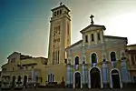 | ||
| Our Lady of Manaoag College | formerly an old convent beside Manaoag Church | Pangasinan | Manaoag, Pangasinan | 16.043014°N 120.489346°E |  Upload Photo | ||
| Manaoag Town Hall | where the Municipal Government of Manaoag is located | Pangasinan | Manaoag, Pangasinan | 16.043631°N 120.487125°E | 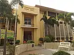 | ||
| Veterans Freedom Hall | Pangasinan | Manaoag, Pangasinan | 16.043500°N 120.487178°E | 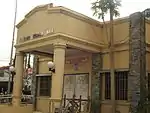 | |||
| Llamido House | Constructed in 1960's | Pangasinan | Manaoag, Pangasinan | 351 N. Garcia Road (Guico Street) | 16.042757°N 120.487908°E | 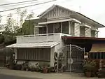 | |
| Lazaro Corpuz House | Constructed in 1935 | Pangasinan | Manaoag, Pangasinan | N. Garcia Road (Guico Street) | 16.042459°N 120.488209°E | 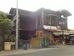 | |
| Macario Corpuz House | Constructed in 1920s | Pangasinan | Manaoag, Pangasinan | 285 N. Garcia Road (Guico Street) | 16.042353°N 120.488329°E | 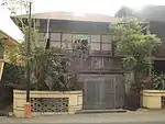 | |
| Filomena House | Constructed in 1950s | Pangasinan | Manaoag, Pangasinan | 281 N. Garcia Road (Guico Street) | 16.042447°N 120.488539°E | 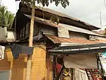 | |
| Tanguilig House | Constructed in 1920s | Pangasinan | Manaoag, Pangasinan | 240 N. Garcia Road (Guico Street) | 16.041939°N 120.488616°E | 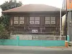 | |
| Dionisio Guico House | Constructed in 1958 | Pangasinan | Manaoag, Pangasinan | 272 N. Garcia Road (Guico Street) | 16.042013°N 120.488932°E | 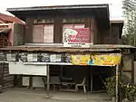 | |
| Mendoza House | Constructed in 1930s | Pangasinan | Manaoag, Pangasinan | 279 N. Garcia Road (Guico Street) | 16.042287°N 120.488692°E | 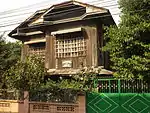 | |
| Felipe Guico House | Constructed in 1940s | Pangasinan | Manaoag, Pangasinan | 270 N. Garcia Road (Guico Street) | 16.042119°N 120.488817°E | 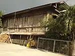 | |
| Berceles House | Constructed in 1960s | Pangasinan | Manaoag, Pangasinan | 271 N. Garcia Road (Guico Street) | 16.041851°N 120.488730°E | 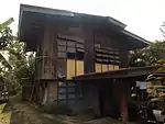 | |
| Bautista House | Constructed in 1930s | Pangasinan | Manaoag, Pangasinan | Guico Street | 16.041473°N 120.488806°E | 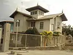 |
Gallery
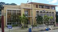 Manaoag Town Hall (Poblacion)
 Manaoag Tourism Youth Center
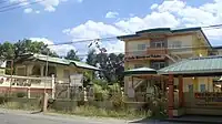 St. Camillus College of Manaoag and Maternity & Polyclinic
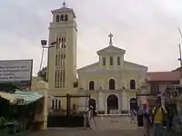 Basilica of Our Lady of the Holy Rosary of Manaoag
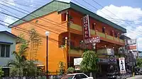 Hotel Manaoag (Soriano Street
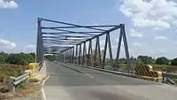 Aloragat bridge and Aloragat River
References
- Municipality of Manaoag | (DILG)
- "2015 Census of Population, Report No. 3 – Population, Land Area, and Population Density" (PDF). Philippine Statistics Authority. Quezon City, Philippines. August 2016. ISSN 0117-1453. Archived (PDF) from the original on May 25, 2021. Retrieved July 16, 2021.
- Census of Population (2020). "Region I (Ilocos Region)". Total Population by Province, City, Municipality and Barangay. Philippine Statistics Authority. Retrieved 8 July 2021.
- "PSA Releases the 2018 Municipal and City Level Poverty Estimates". Philippine Statistics Authority. 15 December 2021. Retrieved 22 January 2022.
- "Manaoag". Province of Pangasinan. Government of the Philippines. Retrieved 2023-03-14.
- "History". Municipality of Laoac. Government of the Philippines. Retrieved 2023-03-09.
- "Laoac". Province of Pangasinan. Government of the Philippines. Retrieved 2023-03-14.
- "Manaoag, Pangasinan: Average Temperatures and Rainfall". World Weather Online. Retrieved 12 October 2015.
- Census of Population (2015). "Region I (Ilocos Region)". Total Population by Province, City, Municipality and Barangay. Philippine Statistics Authority. Retrieved 20 June 2016.
- Census of Population and Housing (2010). "Region I (Ilocos Region)". Total Population by Province, City, Municipality and Barangay. National Statistics Office. Retrieved 29 June 2016.
- Censuses of Population (1903–2007). "Region I (Ilocos Region)". Table 1. Population Enumerated in Various Censuses by Province/Highly Urbanized City: 1903 to 2007. National Statistics Office.
- "Province of Pangasinan". Municipality Population Data. Local Water Utilities Administration Research Division. Retrieved 17 December 2016.
- "Poverty incidence (PI):". Philippine Statistics Authority. Retrieved December 28, 2020.
- "Estimation of Local Poverty in the Philippines" (PDF). Philippine Statistics Authority. 29 November 2005.
- "2003 City and Municipal Level Poverty Estimates" (PDF). Philippine Statistics Authority. 23 March 2009.
- "City and Municipal Level Poverty Estimates; 2006 and 2009" (PDF). Philippine Statistics Authority. 3 August 2012.
- "2012 Municipal and City Level Poverty Estimates" (PDF). Philippine Statistics Authority. 31 May 2016.
- "Municipal and City Level Small Area Poverty Estimates; 2009, 2012 and 2015". Philippine Statistics Authority. 10 July 2019.
- "PSA Releases the 2018 Municipal and City Level Poverty Estimates". Philippine Statistics Authority. 15 December 2021. Retrieved 22 January 2022.
- "2019 National and Local Elections" (PDF). Commission on Elections. Retrieved March 7, 2022.
External links
- Manaoag Profile at PhilAtlas.com
- Municipal Profile at the National Competitiveness Council of the Philippines
- Manaoag at the Pangasinan Government Website
- Local Governance Performance Management System
- Philippine Standard Geographic Code
- Philippine Census Information
- Our Lady of Manaoag Archived 2021-01-27 at the Wayback Machine
- Manaoag Shrine Archived 2013-05-12 at the Wayback Machine
Places adjacent to Manaoag | ||||||||||||||||
|---|---|---|---|---|---|---|---|---|---|---|---|---|---|---|---|---|
| ||||||||||||||||
| Municipalities |
|
|---|---|
| Component cities | |
| Independent component city |
|
| Barangays | |