Baraut
Baraut is a city and municipal board in Baghpat district, Uttar Pradesh, India.
Baraut | |
|---|---|
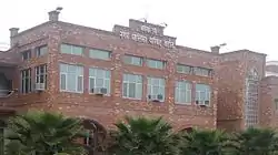
 Office of Baraut Municipality | |
 Baraut  Baraut | |
| Coordinates: 29°10′02″N 77°26′29″E | |
| Country | India |
| State | Uttar Pradesh |
| Division | Meerut |
| District | Baghpat |
| Government | |
| • Body | Municipality |
| • Chairperson | Babita Tomar[1] |
| Area | |
| • Total | 10.36 km2 (4.00 sq mi) |
| Elevation | 231 m (758 ft) |
| Population (2011) | |
| • Total | 103,764 |
| Language | |
| • Official | Hindi[2] |
| • Additional official | Urdu[2] |
| • Regional | Khariboli |
| Time zone | UTC+5:30 (IST) |
| PIN | 250611 |
| Telephone code | 91-1234 xxx xxx |
| Vehicle registration | UP-17 |
| Sex ratio | 70.22% ♂/51.12% ♀ |
| Literacy rate | Crude (66.2%), Effective (76.7%) |
Name
According to Paul Whalley, the name Baṛaut is derived from baṛ, one of the Hindi-Urdu names for the banyan tree, plus the Sanskrit possessive suffix -vat (which has often been shortened to -aut in modern place names), so the name originally meant "having banyan trees".[3]: 89–90
Geography
Baraut is located at 29.6°N 77.16°E, covering an area of 10.36 square kilometers (4.00 sq mi) and lying between the Ganga and Yamuna river plains. Its average elevation is 231 m (758 feet). Baraut is served by NH-709B and state highways SH-57 and SH-82.
Baraut is located 55 kilometers (34 mi) from Delhi (the national capital of India) and 55 kilometers from Meerut, and is within the National Capital Region (NCR).
Demographics
Population
As of 2011 Indian Census, Baraut had a total population of 103,764, of which 55,013 were males and 48,751 were females. Population within the age group of 0 to 6 years was 14,149. The total number of literates in Baraut was 68,690 , which constituted 66.2% of the population with male literacy of 71.8% and female literacy of 59.9%. The effective literacy rate of 7+ population of Baraut was 76.7%, of which male literacy rate was 83.5% and female literacy rate was 69.0%. The Scheduled Castes population was 6,357. Baraut had 17924 in 2011.[4]
Administration and politics
Baraut is one of the 403 constituencies of the Uttar Pradesh Legislative Assembly, India. The first election of this assembly constituency was held in 1952.[7] In 1952, Umrao Dutta Ved won the elections and became the first Member of Legislative Assembly (MLA) of Baraut.[8] After the 1969 elections, the constituency was dissolved. In 2008, when the "Delimitation of Parliamentary and Assembly Constituencies Order, 2008" was passed, the constituency was re-constituted and elections were held in 2012. The constituency is assigned identification number 51. Krishan Pal Malik of BJP is the MLA after winning second consecutive term in 2017 and 2022.[9] Dushyant Tomar aka Amit Rana is the Chairman of the town.[10]
Baraut is part of the National Capital Region (NCR). It is part of the Baghpat district, which was established as a separate district in 1997. Prior to that, Baghpat was a tehsil within Meerut district.
References
- "Welcome to Nagar Palika Parishad, Baraut". nppbaraut.in. Retrieved 26 July 2023.
- "52nd Report of the Commissioner for Linguistic Minorities in India" (PDF). nclm.nic.in. Ministry of Minority Affairs. Archived from the original (PDF) on 25 May 2017. Retrieved 23 November 2020.
- Whalley, Paul (1927). "Place-Names in the United Provinces of Agra and Oudh, Chapter III, Section 2: Suffixes". The Journal of the United Provinces Historical Society. 3 (3): 52–98. Retrieved 22 July 2023.
- "Census of India: Baraut". www.censusindia.gov.in. Retrieved 23 November 2020.
- "C-1 Population By Religious Community - Baraut". censusindia.gov.in. Retrieved 28 March 2022.
- "About Baraut". 2002. Archived from the original on 10 April 2007. Retrieved 15 July 2018.
- "DPACO (1952)". Election Commission of India. Retrieved 16 December 2018.
- "1952 Election Results" (PDF). Election Commission of India website. Retrieved 1 October 2015.
- "krishan-pal-malik in Uttar Pradesh Assembly Elections 2022". News18. Retrieved 29 May 2022.
- "बड़ौत के चेयरमैन दुष्यंत तोमर समर्थकों से मिले". Amar Ujala (in Hindi). 3 December 2017. Retrieved 29 May 2022.