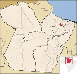
Barcarena, Pará
Barcarena is a Brazilian municipality in the state of Pará adjacent the Tocantins River. It has a population of 127,027 and is part of the Belém metropolitan area.[4] The city's economy relies largely on agriculture and bauxite. There are also facilities for pig iron nearby.[5] They city and port is developing as a major transshipping port that takes goods for international export linked by rail from nearby inland ports, from all over Brazil, speeding up shipment and reducing time and costs as opposed to traditional megaports in the Southeast.
Barcarena | |
|---|---|
Municipality | |
 Flag  Seal | |
 Location in Pará | |
 Barcarena Location in Brazil | |
| Coordinates: 01°30′21″S 48°37′33″W | |
| Country | |
| Region | Northern |
| State | Pará |
| Mesoregion | Belém |
| Microregion | Belém |
| Cont. inhabited | Prior to Portuguese rule[1] |
| Freguesia | 1758 |
| Incorporated (municipality) | May 10, 1897 [1] |
| Government | |
| • Mayor | Renato Ogawa |
| Area | |
| • Total | 1,310.588 km2 (506.021 sq mi) |
| Elevation | 15 m (49 ft) |
| Population (2020 [3]) | |
| • Total | 127,027 |
| Time zone | UTC−3 (BRT) |
| CEP postal code | 68445-000 |
| Area code | 91 |
| Website | barcarena.pa.gov.br |
History
The town was originally inhabited by the Aruá Indians. In 1709 Jesuits came.
On October 6, 2015 the livestock vessel "MV Haidar" capsized in the Vila do Conde port due to an unsuccessful turning maneuver. It had 4,900 live cattle and almost 700 metric tonnes of oil on board.[6][7] 4,400 cattle drowned while locked in the ship's cargo area. About 500 animals could free themselves, but only about 100 survived the accident. Fuel and oil seeped from the wreck into the water and contaminated the Pará river and surrounding beaches, which deprived many local fisher families of their livelihood.[8] Since the removal of the oil slick proved to be complicated, and no consensus regarding responsibility and suitable cleanup efforts could be reached, hundreds of carcasses rotted at the beach and inside the shipwreck for months – a huge burden on the fishery and tourism of the region. The competent Federal Ministry estimated the damage to the residents to be 71 million reais (about 21 million US$). By July 2016 nothing had been paid out yet.[9][10][11]
Geography
Climate
Barcarena has a tropical rainforest climate (Af) with moderate rainfall from August to November and heavy to very heavy rainfall in the remaining months.
| Climate data for Barcarena | |||||||||||||
|---|---|---|---|---|---|---|---|---|---|---|---|---|---|
| Month | Jan | Feb | Mar | Apr | May | Jun | Jul | Aug | Sep | Oct | Nov | Dec | Year |
| Average high °C (°F) | 30.6 (87.1) |
30.5 (86.9) |
30.9 (87.6) |
31.4 (88.5) |
31.7 (89.1) |
31.8 (89.2) |
32.1 (89.8) |
32.1 (89.8) |
32.3 (90.1) |
32.3 (90.1) |
32.0 (89.6) |
31.5 (88.7) |
31.6 (88.9) |
| Daily mean °C (°F) | 26.4 (79.5) |
26.5 (79.7) |
26.5 (79.7) |
27.0 (80.6) |
26.9 (80.4) |
26.8 (80.2) |
27.0 (80.6) |
27.0 (80.6) |
27.1 (80.8) |
27.2 (81.0) |
27.1 (80.8) |
26.8 (80.2) |
26.9 (80.3) |
| Average low °C (°F) | 22.3 (72.1) |
22.5 (72.5) |
22.1 (71.8) |
22.7 (72.9) |
22.2 (72.0) |
21.9 (71.4) |
21.9 (71.4) |
22.0 (71.6) |
22.0 (71.6) |
22.2 (72.0) |
22.3 (72.1) |
22.2 (72.0) |
22.2 (72.0) |
| Average rainfall mm (inches) | 325 (12.8) |
366 (14.4) |
387 (15.2) |
358 (14.1) |
250 (9.8) |
152 (6.0) |
134 (5.3) |
109 (4.3) |
103 (4.1) |
81 (3.2) |
78 (3.1) |
189 (7.4) |
2,532 (99.7) |
| Source: Climate-Data.org[12] | |||||||||||||
References
- "Barcarena - Pará - PA" (PDF) (in Portuguese). Brazilian Institute of Geography and Statistics (IBGE). Retrieved 2018-03-22.
- "Área dos municípios" [Area of Municipalities] (in Portuguese). Brazilian Institute of Geography and Statistics (IBGE). Retrieved 2018-03-22.
- IBGE 2020 cidades.ibge.gov.br
- Browder, Brian John O. Rainforest Cities books.google.com
- http://findarticles.com/p/articles/mi_m3MKT/is_24-1_112/ai_n6106309%5B%5D
- - 4,400 Dead Cows Are Decomposing in a Sunken Ship in a Brazilian River on MotherJones.com
- - MPF convoca audiência com famílias afetadas por naufrágio em Barcarena on Globo.com (Portuguese)
- - Update: Local residents and authorities angry after sinking of cattle carrier Haidar in Barcarena, Brazil on Vesselfinder.com
- - Após 6 meses de naufrágio, navio e bois ainda estão submersos no PA (Portuguese) on Globo.com
- - MPF convoca audiência com famílias afetadas por naufrágio em Barcarena on Globo.com (portuguese)
- - Afetados pelo naufrágio em Barcarena (PA) decidem que debate sobre indenização deve continuar on Mpf.mp.br (Portuguese)
- "Climate: Barcarena". Climate-Data.org. Retrieved August 14, 2020.
