Barkam Town
Barkam is a town in and the seat of Barkam City, in the northwest of Sichuan province, People's Republic of China.
Barkam
马尔康镇 · འབར་ཁམས་རྡལ། · Muerkvua zhen | |
|---|---|
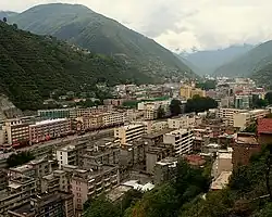 Overview of the town of Barkam | |
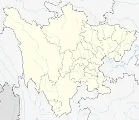 Barkam Location in Sichuan | |
| Coordinates: 31°54′07″N 102°13′03″E | |
| Country | People's Republic of China |
| Province | Sichuan |
| Prefecture | Ngawa |
| County-level city | Barkam |
| Postal code | 624000 |
| Area code | 837 |
| Barkam Town | |||||||
|---|---|---|---|---|---|---|---|
| Chinese name | |||||||
| Simplified Chinese | 马尔康 | ||||||
| Traditional Chinese | 馬爾康 | ||||||
| |||||||
| Tibetan name | |||||||
| Tibetan | འབར་ཁམས། | ||||||
| |||||||
Climate
Due to its elevation, Barkam lies in the transition between a subtropical highland climate (Köppen Cwb) and humid continental climate (Köppen Dwb), with strong monsoonal influences; winters are frosty and summers warm with frequent rain. The monthly 24-hour average temperature ranges from −0.5 °C (31.1 °F) in December and January to 16.4 °C (61.5 °F) in July, while the annual mean is 8.75 °C (47.7 °F). Nearly two-thirds of the annual precipitation of 784 mm (30.9 in) occurs from June to September. With monthly percent possible sunshine ranging from 36% in June to 65% in December, the town receives 2,133 hours of bright sunshine annually. Diurnal temperature variation is large, averaging 16.0 °C (28.8 °F) annually.
| Climate data for Barkam (1991–2020 normals, extremes 1971–2010) | |||||||||||||
|---|---|---|---|---|---|---|---|---|---|---|---|---|---|
| Month | Jan | Feb | Mar | Apr | May | Jun | Jul | Aug | Sep | Oct | Nov | Dec | Year |
| Record high °C (°F) | 22.1 (71.8) |
24.8 (76.6) |
26.8 (80.2) |
31.3 (88.3) |
34.7 (94.5) |
35.7 (96.3) |
35.5 (95.9) |
36.3 (97.3) |
32.4 (90.3) |
30.6 (87.1) |
23.3 (73.9) |
19.3 (66.7) |
36.3 (97.3) |
| Average high °C (°F) | 11.1 (52.0) |
14.4 (57.9) |
17.0 (62.6) |
19.9 (67.8) |
22.5 (72.5) |
23.9 (75.0) |
25.6 (78.1) |
25.8 (78.4) |
23.1 (73.6) |
18.8 (65.8) |
15.3 (59.5) |
11.0 (51.8) |
19.0 (66.2) |
| Daily mean °C (°F) | −0.2 (31.6) |
3.4 (38.1) |
6.8 (44.2) |
10.1 (50.2) |
12.9 (55.2) |
15.1 (59.2) |
16.6 (61.9) |
16.3 (61.3) |
13.7 (56.7) |
9.2 (48.6) |
4.1 (39.4) |
−0.2 (31.6) |
9.0 (48.2) |
| Average low °C (°F) | −7.3 (18.9) |
−4.0 (24.8) |
−0.3 (31.5) |
3.2 (37.8) |
6.6 (43.9) |
10.0 (50.0) |
11.3 (52.3) |
10.9 (51.6) |
8.8 (47.8) |
4.1 (39.4) |
−2.3 (27.9) |
−6.8 (19.8) |
2.9 (37.1) |
| Record low °C (°F) | −16.0 (3.2) |
−13.6 (7.5) |
−12.6 (9.3) |
−6.2 (20.8) |
−2.2 (28.0) |
0.1 (32.2) |
2.2 (36.0) |
1.5 (34.7) |
−0.6 (30.9) |
−5.7 (21.7) |
−10.7 (12.7) |
−16.6 (2.1) |
−16.6 (2.1) |
| Average precipitation mm (inches) | 3.3 (0.13) |
7.8 (0.31) |
27.4 (1.08) |
57.4 (2.26) |
115.6 (4.55) |
164.4 (6.47) |
130.0 (5.12) |
105.2 (4.14) |
122.2 (4.81) |
78.1 (3.07) |
11.5 (0.45) |
3.1 (0.12) |
826 (32.51) |
| Average precipitation days (≥ 0.1 mm) | 2.5 | 5.6 | 10.5 | 14.9 | 20.5 | 22.7 | 19.6 | 17.7 | 18.9 | 16.3 | 5.4 | 2.2 | 156.8 |
| Average snowy days | 4.1 | 6.8 | 6.4 | 1.9 | 0.6 | 0 | 0 | 0 | 0 | 0.9 | 2.9 | 3.3 | 26.9 |
| Average relative humidity (%) | 45 | 44 | 50 | 56 | 65 | 74 | 75 | 74 | 77 | 74 | 59 | 50 | 62 |
| Mean monthly sunshine hours | 196.8 | 175.6 | 184.1 | 185.1 | 181.6 | 147.5 | 167.8 | 173.6 | 155.9 | 156.0 | 186.7 | 200.7 | 2,111.4 |
| Percent possible sunshine | 61 | 56 | 49 | 47 | 42 | 35 | 39 | 43 | 43 | 45 | 60 | 64 | 49 |
| Source 1: China Meteorological Administration[1][2] | |||||||||||||
| Source 2: Weather China[3] | |||||||||||||
Demographics
The city had a population of 54,735 in 1999.[4] The area is traditionally inhabited by a branch of Rgyalrong people who speak the Situ language.[5]
Notes
- 中国气象数据网 – WeatherBk Data (in Simplified Chinese). China Meteorological Administration. Retrieved 13 April 2023.
- 中国气象数据网 (in Simplified Chinese). China Meteorological Administration. Retrieved 13 April 2023.
- 马尔康 - 气象数据 -中国天气网 (in Chinese). Weather China. Retrieved 27 November 2022.
- National Population Statistics Materials by County and City - 1999 Period, in China County & City Population 1999, Harvard China Historical GIS
- "Rgyalrong Culture" 嘉绒人文. Ma'erkang City Government website. Archived from the original on 2019-03-28. Retrieved 2019-09-19.
External links
- (in Chinese) Maerkang County Government site Archived 2019-12-25 at the Wayback Machine - Google translation
- (in Chinese) Maerkang - bashu.net - Google translation