Barrett Buttress
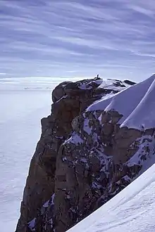
Barrett Buttress (72°13′S 65°36′W) is a nunatak rising to 1,600 metres (5,250 ft) at the south margin of Goodenough Glacier, 9 nautical miles (17 km) southwest of the Blanchard Nunataks in western Palmer Land. The feature has a sheer northwest face 150 metres (500 ft) high; the southeast side is level with the snow plateau. It was mapped by the United States Geological Survey from U.S. Navy aerial photographs taken 1966–69, and was named by the UK Antarctic Place-Names Committee in 1977 after Richard G. Barrett, a British Antarctic Survey surveyor at Stonington Island and Adelaide Island stations, 1974–76.[1]
References
![]() This article incorporates public domain material from "Barrett Buttress". Geographic Names Information System. United States Geological Survey.
This article incorporates public domain material from "Barrett Buttress". Geographic Names Information System. United States Geological Survey.