Bass Coast Shire
The Bass Coast Shire is a local government area in Victoria, Australia, located in the southeastern part of the state. It covers an area of 866 square kilometres (334 sq mi) and in June 2018 had a population of 35,327.[1] It includes the towns of Bass, Cape Paterson, Cape Woolamai, Corinella, Coronet Bay, Cowes, Inverloch, Kilcunda, Lang Lang, Newhaven, Rhyll, San Remo, Summerlands and Wonthaggi as well as the historic locality of Krowera. It also includes the popular tourist destination Phillip Island. It was formed in 1994 from the amalgamation of the Shire of Bass, Shire of Phillip Island, Borough of Wonthaggi, parts of the Shire of Woorayl, Shire of Korumburra and City of Cranbourne.[2]
| Bass Coast Shire Victoria | |||||||||||||||
|---|---|---|---|---|---|---|---|---|---|---|---|---|---|---|---|
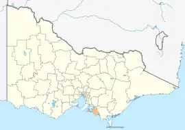 Location in Victoria | |||||||||||||||
| Population | 35,327 (2018)[1] | ||||||||||||||
| • Density | 40.793/km2 (105.65/sq mi) | ||||||||||||||
| Established | 1994 | ||||||||||||||
| Gazetted | 2 December 1994[2] | ||||||||||||||
| Area | 866 km2 (334.4 sq mi)[1] | ||||||||||||||
| Mayor | Cr Michael Whelan[3] | ||||||||||||||
| Council seat | Wonthaggi | ||||||||||||||
| Region | Gippsland | ||||||||||||||
| State electorate(s) | Bass | ||||||||||||||
| Federal division(s) | Monash | ||||||||||||||
| Website | Bass Coast Shire | ||||||||||||||
| |||||||||||||||
The Shire is governed and administered by the Bass Coast Shire Council; its seat of local government and administrative centre is the council headquarters in Wonthaggi, with other service centres located in Cowes, Grantville and Inverloch. The Shire is named after its most precious asset, the coasts of Bass Strait and Western Port.
Council
Current composition
The council is composed of three wards and nine councillors, with three councillors elected to represent each ward.[4]
| Ward | Party | Councillor | Notes | |
|---|---|---|---|---|
| Bunurong | Independent | Les Larke | ||
| National | Brett Tessari | |||
| Independent | Leticia Laing | Deputy Mayor (2021/22) | ||
| Island | Independent | Ron Bauer | President of the Reason Party in Victoria from 2017 until 2018.[5] | |
| Independent | David Rooks | |||
| Independent | Michael Whelan | Current Mayor (2021/22) | ||
| Westernport | Independent | Clare Le Serve | ||
| Independent | Bruce Kent | |||
| Independent | Rochelle Halstead | |||
Administration and governance
The council meets in the council chambers at the council headquarters in the Wonthaggi Municipal Offices, which is also the location of the council's administrative activities. It also provides customer services at both its administrative centre in Wonthaggi, and its service centre in Cowes.
Townships and localities
The 2021 census, the shire had a population of 40,789 up from 32,804 in the 2016 census[6]
| Population | ||
|---|---|---|
| Locality | 2016 | 2021 |
| Adams Estate | 59 | 83 |
| Almurta | 48 | 66 |
| Anderson | 28 | 26 |
| Archies Creek | 22 | 32 |
| Bass | 359 | 405 |
| Cape Paterson | 891 | 1,111 |
| Cape Woolamai | 1,676 | 2,301 |
| Churchill Island | 0 | 0 |
| Corinella | 791 | 1,181 |
| Coronet Bay | 791 | 1,108 |
| Cowes | 4,839 | 6,593 |
| Dalyston | 583 | 843 |
| Glen Alvie | 165 | 182 |
| Population | ||
|---|---|---|
| Locality | 2016 | 2021 |
| Glen Forbes | 106 | 118 |
| Grantville | 831 | 1,168 |
| Harmers Haven | 37 | 62 |
| Inverloch^ | 5,437 | 6,526 |
| Jam Jerrup | 97 | 106 |
| Kernot | 100 | 118 |
| Kilcunda | 396 | 578 |
| Kongwak^ | 197 | 207 |
| Krowera^ | 108 | 134 |
| Lance Creek | 136 | 143 |
| Lang Lang^ | 1,585 | 2,556 |
| Loch^ | 638 | 707 |
| Newhaven | 449 | 547 |
| Population | ||
|---|---|---|
| Locality | 2016 | 2021 |
| North Wonthaggi | 2,806 | 3,475 |
| Outtrim^ | 235 | 270 |
| Pioneer Bay | 352 | 365 |
| Pound Creek^ | 104 | 126 |
| Queensferry | * | # |
| Rhyll | 568 | 836 |
| Ryanston | 271 | 324 |
| San Remo | 1,254 | 1,700 |
| Silverleaves | 211 | 322 |
| Smiths Beach | 226 | 315 |
| South Dudley | 461 | 421 |
| St Clair | 49 | 44 |
| Summerlands | 0 | 0 |
| Population | ||
|---|---|---|
| Locality | 2016 | 2021 |
| Sunderland Bay | 234 | 306 |
| Sunset Strip | 427 | 503 |
| Surf Beach | 533 | 670 |
| Tenby Point | 184 | 206 |
| The Gurdies | 191 | 243 |
| Ventnor | 855 | 982 |
| Wattle Bank | 177 | 250 |
| West Creek | 109 | 113 |
| Wimbledon Heights | 373 | 421 |
| Wonthaggi | 4,965 | 5,215 |
| Woodleigh | 125 | 126 |
| Woolamai | 208 | 245 |
^ - Territory divided with another LGA
* - Not noted in 2016 Census
# - Not noted in 2021 Census
Facilities
- Local markets[7]
Cape Paterson
- Swimming Rockpool – Safety Beach, Browns Bay, Surf Beach Road[8]
- Bunurong Marine Park
Wonthaggi
- Lower Powlett Road – Williamsons Beach, Powlett River, Wonthaggi Wind Farm and Victorian Desalination Plant (tours and walking/cycling/horse riding)
- Bass Coast Rail Trail – walk/cycle/horse trot
- Historic mine whistle – sounds 12 noon every day in the centre of Wonthaggi, mine shaft tower, Apex Park, Murray Street[7]
- Wonthaggi Museum – open Saturday mornings, Murray Street[9]
- State Coal Mine – museum and tours, Garden Street[10]
- Coal mine ruins – Number 5 Brace & the McBride tunnel entry, off West Area Road Wonthaggi and scattered around the region[7]
- Wonthaggi Golf Course – 18 hole, par 72, ACR 70, easy walk, McKenzie Street[11]
- Large chain stores
- Wonthaggi Hospital – Smoking ban, Graham Street[12]
Phillip Island
- Phillip Island Penguin Parade
- Australian motorcycle Grand Prix
- Pyramid Rock Festival on New Year's Eve
- Nobbies Centre at Seal Rocks
Krowera
- Garlic Farm, Olive Farm, Wayside Lookout, Dairy Farms
Kilcunda
- Kilcunda Trestle Bridge
Protected areas
Collecting empty seashells, driftwood, twigs, sea glass and other non-living materials or interesting rubbish of small size and in small quantities is legal from most beaches along the Bass Coast, with the exception of Wilsons Promontory, the Bunurong Marine National Park and most of Phillip Island.
On Phillip Island most beaches are off-limits for shell collecting and are run by Phillip Island Nature Parks, with the exceptions of Ventnor, Cowes, Rhyll and Newhaven.[14]
The Bunurong Marine National Park is a middle outstretching section of Bunurong Marine Park along the coastline of Harmers Haven, Cape Paterson and Inverloch. The restricted zone (Bunurong Marine National Park inside Bunurong Marine Park) is an area south-west past Cape Paterson's Safety Beach and Undertow Bay; namely The Oaks, Twin Reefs, Shack Bay and Eagles Nest.
See also
References
- "3218.0 – Regional Population Growth, Australia, 2017-18: Population Estimates by Local Government Area (ASGS 2018), 2017 to 2018". Australian Bureau of Statistics. Australian Bureau of Statistics. 27 March 2019. Retrieved 25 October 2019. Estimated resident population, 30 June 2018.
- Victoria Government Gazette – Online Archive (1837–1997). "S94 of 1994 - Order estg (Part 2) the Bass Coast Shire". State Library of Victoria. State Government of Victoria (published 2 December 1994). p. 2. Retrieved 10 January 2014.
- "Councillors and Elections".
- Local Government in Victoria. "Bass Coast Shire Council". Victorian Electoral Commission. State Government of Victoria. Retrieved 3 November 2017.
- "RON BAUER". BASS COAST RATEPAYERS AND RESIDENTS ASSOCIATION.
- "Census | Australian Bureau of Statistics". www.abs.gov.au. 11 January 2023.
- Bass Coast Information Centres (PDF), archived from the original (PDF) on 17 March 2012, retrieved 19 November 2013
- Bass Coast Information Centres, retrieved 13 November 2013
- Wonthaggi Historical Society, retrieved 11 November 2013
- Parks Victoria, retrieved 27 October 2013
- Wonthaggi Golf Club, retrieved 11 November 2013
- Bass Coast Regional Health, archived from the original on 28 September 2013, retrieved 30 October 2013
- Inverloch Shell Museum, retrieved 14 November 2013
- Department of Environment And Primary Industries, retrieved 11 November 2013
External links
- Bass Coast Shire Council official website
- Metlink local public transport map
- Link to Land Victoria interactive maps Archived 24 March 2022 at the Wayback Machine
- Bass Coast Security
Localities in the Bass Coast Shire | |||||||
|---|---|---|---|---|---|---|---|
| Mainland |
|  | |||||
| Philip Island |
| ||||||