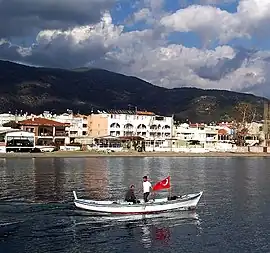
Edremit, Balıkesir
Edremit is a municipality and district of Balıkesir Province, Turkey.[2] Its area is 682 km2,[3] and its population is 167,901 (2022).[1]
Edremit | |
|---|---|
 | |
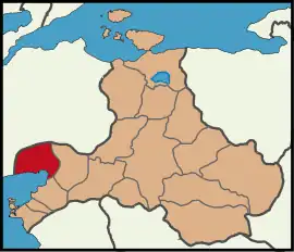 Map showing Edremit District in Balıkesir Province | |
 Edremit Location in Turkey 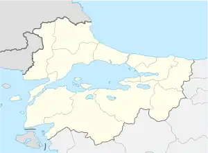 Edremit Edremit (Marmara) | |
| Coordinates: 39°35′32″N 27°01′12″E | |
| Country | Turkey |
| Province | Balıkesir |
| Government | |
| • Mayor | Selman Hasan Arslan (CHP) |
| Area | 682 km2 (263 sq mi) |
| Elevation | 29 m (95 ft) |
| Population (2022)[1] | 167,901 |
| • Density | 250/km2 (640/sq mi) |
| Time zone | TRT (UTC+3) |
| Postal code | 10300 |
| Area code | 0266 |
| Website | www |
It is situated at the tip of the gulf with the same name (Gulf of Edremit), with its town centre a few kilometres inland, and is an important centre of trade, along with the other towns that are situated on the same gulf (namely Ayvalık, Gömeç, Burhaniye and Havran). It is also one of the largest district centres of Balıkesir Province. The district of Edremit, especially around Kazdağı, is largely covered with forests. The mayor of Edremit municipality is Selman Hasan Arslan.[4]
History
The modern city of Edremit is named after the ancient city of Adramyttion (Ἀδραμύττιον) or Adramytteion (Ἀδραμύττειον), a city of Asia Minor on the coast of Aeolis which is in near city Modern Burhaniye
Tahtacı Turkmen, descendants of the army of Shah Ismail I, settled in the mountains near Edremit after their defeat in the Battle of Chaldiran in 1514.[5]
By 1819, Henry Alexander Scammell Dearborn reported that Edremit was only populated by "a few Greek fishermen".[6] In 1912, the town had 6200 inhabitants, 1200 of which were Greeks.[7] At this time, the district had 19 Greek schools and roughly 600 pupils.[8]
In May 1914, thousands of Muslim refugees who had fled from the Balkans arrived in the town of Edremit and proceeded to ransack the shops and homes of the town's Greek community. According to Arnold J. Toynbee, the Ottoman government armed and organised the refugees. Many Greeks found refuge in the town church before fleeing to the harbour where they were then granted passage to the neighbouring island of Lesbos. Turks continued to massacre or evict Greeks in the following months in surrounding villages.[9] The Greek army occupied the town on 19 June 1920 but withdrew in late August 1922 and all remaining Greeks fled or were killed by the Turkish army.[10]
Composition
There are 47 neighbourhoods in Edremit District:[11]
- Akçay
- Altınkum
- Altınoluk
- Arıtaşı
- Atatürk
- Avcılar
- Beyoba
- Bostancı
- Çamcı
- Camivasat
- Çamlıbel
- Cennetayağı
- Çıkrıkçı
- Cumhuriyet
- Darsofa
- Dereli
- Doyuran
- Eroğlan
- Gazicelal
- Gaziilyas
- Güre
- Güre-Cumhuriyet
- Hacıarslanlar
- Hacıtuğrul
- Hamidiye
- Hekimzade
- İbrahimce
- İkizçay
- İskele
- Kadıköy
- Kapıcıbaşı
- Kavlaklar
- Kızılkeçili
- Mehmetalanı
- Narlı
- Ortaoba
- Pınarbaşı
- Şahindere
- Sarıkız
- Soğanyemez
- Tahtakuşlar
- Turhanbey
- Tuzcumurat
- Yaşyer
- Yaylaönü
- Yolören
- Zeytinli
Economy
Edremit's economy relies largely on the production of olives, as well as on tourism. Edremit is known as the olive capital of Turkey. Kaz Dağı National Park, extending around the ancient Mount Ida (mentioned in Homer's epic poems such as the Iliad), is situated within the boundaries of Edremit district and is an important tourist attraction with its natural scenery and a number of picturesque small villages around it.
Demographics
In ethno-cultural terms, the population of Edremit is a mixture of Balkan Turks and Balkan Albanians, descendants of immigrants from Balkans, Aegean Islands, some Circassians, as well as Tahtacı Turkmens, who pursue their own traditions and life-style to this day. A private museum of ethnography in the village of Tahtakuşlar is one of the rare institutions in Turkey focusing on Tahtacı culture.
Notable people
- Germanos Karavangelis (1866–1935), Metropolitan Bishop of Kastoria and later Amaseia
- Benjamin I of Constantinople (1871-1946), Ecumenical Patriarch of Constantinople
- Panos Dukakis (1896–1979), father of American politician Michael Dukakis
- Sabahattin Ali (1907–1948), author and journalist
- Hülya Avşar (b. 1963), actress
- Caner Erkin (b. 1988), professional footballer
Twin towns — sister cities
Edremit is twinned with:
References
- "Address-based population registration system (ADNKS) results dated 31 December 2022, Favorite Reports" (XLS). TÜİK. Retrieved 22 May 2023.
- Büyükşehir İlçe Belediyesi, Turkey Civil Administration Departments Inventory. Retrieved 8 June 2023.
- "İl ve İlçe Yüz ölçümleri". General Directorate of Mapping. Retrieved 22 May 2023.
- Gazete, Banka (22 November 2021). "Edremit Belediyesi zeytinleri hasat ediliyor". Gazete Banka. p. https://gazetebanka.com/. Retrieved 22 November 2021.
- Ayliffe (2003), p. 518
- Dearborn (1819), pp.51-52
- Pétridès (1912), coll. 595-596
- Dieterich (1918), p. 45
- Milton (2009), pp. 48-50
- Kiminas (2009), p. 81
- Mahalle, Turkey Civil Administration Departments Inventory. Retrieved 22 May 2023.
- Sister/Twin Cities of Balıkesir Province
Bibliography
- Ayliffe, Rosie (2003). The Rough Guide to Turkey. Rough Guides. ISBN 9781843530718.
- Dearborn, Henry Alexander Scammell (1819). A Memoir on the Commerce and Navigation of the Black Sea: And the Trade and Maritime Geography of Turkey and Egypt, Vol. 2. Wells & Lilly. p. 51.
adramiti.
- Dieterich, Karl (1918). Hellenism in Asia Minor. Translated by Carrol N. Brown. Oxford University Press.
- Kiminas, Demetrius (2009). The Ecumenical Patriarchate: A History of Its Metropolitanates with Annotated Hierarch Catalogs. Wildside Press LLC. ISBN 9781434458766.
- Milton, Giles (2009). Paradise Lost: Smyrna 1922. Sceptre. ISBN 9780340837870.
- Pétridès, S. (1912). Dictionnaire d'Histoire et de Géographie Ecclésiastiques, ed. R. Aubert & E. Van Cauwenberch, vol. 1 (in French).
External links
Edremit, Balıkesir in Balıkesir Province of Turkey | |||||||||||||||||||||||||||
|---|---|---|---|---|---|---|---|---|---|---|---|---|---|---|---|---|---|---|---|---|---|---|---|---|---|---|---|
| Districts |  Districts of Balıkesir | ||||||||||||||||||||||||||
| |||||||||||||||||||||||||||
Metropolitan municipalities are bolded. | |||||||||||||||||||||||||||
![]() This article incorporates text from a publication now in the public domain: Easton, Matthew George (1897). "Adramyttium". Easton's Bible Dictionary (New and revised ed.). T. Nelson and Sons.
This article incorporates text from a publication now in the public domain: Easton, Matthew George (1897). "Adramyttium". Easton's Bible Dictionary (New and revised ed.). T. Nelson and Sons.