Becher Point
Becher Point is the southernmost point of Warnbro Sound in Port Kennedy in Western Australia.[1] It was the site of multiple ship beachings.[2][3] It is a reference point for the adjacent Ramsar Becher Point Wetlands that lie inland from the point. It offers significant conservation value.[4] It has been identified as a site for assessing Holocene environment on the coastline.[5] As a place name, Port Kennedy is the name of a locality that is found where Becher point is, however Port Kennedy is not a notable coastal feature.[6]

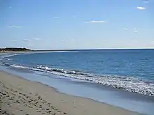
Becher Point, seen from near the Port Kennedy boat ramp
Notes
- Roe, John Septimus; Great Britain. Hydrographic Dept; J. & C. Walker (1840), Warnbro Sound by Lieut.J.S. Roe R.N., Surveyor General of W. Australia, 1839, Hydrographic Office of the Admiralty, retrieved 19 December 2013.
- "REMOVAL OF THE STEAMER GEORGETTE FROM BECHER POINT TO GARDEN ISLAND". The Herald. Fremantle, WA. 1 November 1873. p. 3. Retrieved 19 December 2013 – via National Library of Australia.
- "WESTERN AUSTRALIA". South Australian Register. Adelaide. 1 August 1878. p. 5. Retrieved 19 December 2013 – via National Library of Australia.
- Conservation Council of Western Australia (1991), National Estate values and significance of the Port Kennedy/Point Becher area of Western Australia : a submission to the Australian Heritage Commission, The Council, retrieved 19 December 2013
- Semeniuk, Christopher; Milne, L; Ladd, P; Semeniuk, V (2006), Pollen in the surface sediments of wetlands in the Becher Point area, southwestern Australia: a baseline for use in interpreting Holocene sequences, Department of Exploration Geophysics, retrieved 19 December 2013
- Murray and Hercock do not have a listing for Port Kennedy in Murray, Ian; Hercock, Marion; Murray, Ian; Hercock, Marion (2008), Where on the coast is that?, Hesperian Press, ISBN 978-0-85905-452-2, whereas Quality Publishing Australia (2007), Roads & tracks Western Australia (5th ed.), Quality Publishing Australia, ISBN 978-1-876723-35-4 chooses to identify Bridport Point 1km west, and omits Becher Point
This article is issued from Wikipedia. The text is licensed under Creative Commons - Attribution - Sharealike. Additional terms may apply for the media files.