Warra, Queensland
Warra is a rural town and locality in the Western Downs Region, Queensland, Australia.[2][3] In the 2016 census, the locality of Warra had a population of 205 people.[1]
| Warra Queensland | |||||||||||||||
|---|---|---|---|---|---|---|---|---|---|---|---|---|---|---|---|
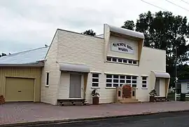
 Warra Memorial Hall | |||||||||||||||
 Warra | |||||||||||||||
| Coordinates | 26.93°S 150.9202°E | ||||||||||||||
| Population | 205 (2016 census)[1] | ||||||||||||||
| • Density | 1.0411/km2 (2.697/sq mi) | ||||||||||||||
| Postcode(s) | 4411 | ||||||||||||||
| Area | 196.9 km2 (76.0 sq mi) | ||||||||||||||
| Time zone | AEST (UTC+10:00) | ||||||||||||||
| Location |
| ||||||||||||||
| LGA(s) | Western Downs Region | ||||||||||||||
| State electorate(s) | Callide | ||||||||||||||
| Federal division(s) | Maranoa | ||||||||||||||
| |||||||||||||||
Geography

Warra is on the Darling Downs, a farming area in Queensland. It is on the Warrego Highway, 256 kilometres (159 mi) north west of the state capital, Brisbane.
The locality is bounded to the north by Haystack Road and Seigmeiers Road and to the south-west by the Condamine River. The town is located to the west of centre of the locality.[4]
The Warrego Highway and Western railway line enter the locality from the south-east (Macalister), pass through the town, and exit to the west (Brigalow). Warra railway station serves the town (26.9280°S 150.9200°E).[5] The highway is known as Thorne Street within the town.[4]
Haystack is a neighbourhood in the north-west of the locality on the boundary with Tuckerang (26.85°S 150.9166°E).[6]
The land use is a mixture of dry and irrigated cropping with some grazing on native vegetation.[4]
History

The town takes its name from the Warra Warra pastoral run, which was previously called Cobble Cobble. The run was operated by Henry Dennis in the late 1840s, then by Colin McKenzie from 1848, then by Mr Thorne circa 1864. The name Warra Warra is believed to be from the Mandandanji language meaning a woman carrying a load or plenty of water.[2]
Warra Provisional School opened on 12 April 1881. On 21 January 1889, it became Warra State School. In 1977 a pre-school was added.[7]
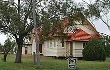
On Friday 9 November 1906, Archdeacon Edward Bush Trotter, assisted by the Reverend William Powning Glover of Dalby, laid the foundation stone for All Saints' Anglican Church.[8] On Tuesday 26 March 1907, Archbishop St Clair Donaldson officially opened and dedicated the church.[9][10]

In April 1907, Samuel Alexander Taylor of Logie Plains pastoral station decided to build a Presbyterian church in Warra at his own expense.[11] It is unclear when the Presbyterian Church opened, but it was in operation by May 1908.[12][13][14] In the 1970s, when the Uniting Church in Australia was created through amalgamation of Presbyterian, Methodist and Congregational churches, it became Warra Uniting Church. In 2005, the church at 14 Lytton Street (26.9311°S 150.9187°E) was sold into private ownership and then converted into a residence.[15]
Daiwan State School opened in 18 October 1910. It may also have been known as Haystack Plains State School. In 1924, it was renamed Haystack State School. It closed in 1968.[7] In 1921, it was on the south-west corner of Haystack Noola Road and Haystack North Road in neighbouring Tuckerang (26.8215°S 150.9182°E).[16] In 1938, it was at 1054 Haystack Road in Warra (26.8471°S 150.9146°E).[17]
On Sunday 30 March 1913, Archbishop James Duhig blessed and officially opened St Francis Xavier Catholic Church.[18][19] The church was destroyed in a storm on 15 December 1980.[20]
Braeside State School opened on 24 May 1915 and closed on 31 October 1923. On 31 January 1928, it reopened and closed permanently on 4 August 1950.[7]

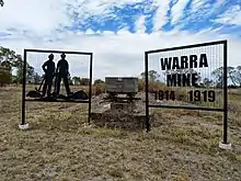
Between December 1915 and July 1919, the Queensland Labor Government operated a coal mine at Warra, one of several such State Enterprises. The mine supplied coal for the southern railways, and, by 1915, was producing 120 tons weekly which could be loaded directly into engines at the pithead. However, the mine was plagued from the start with water seepage problems, causing the original shaft to be abandoned after November 1916. The mine yielded a total 13,528 tons of coal, and the net financial result was a loss of £38,058.[21]
The Warra Honour Board was unveiled on 14 May 1917 by Member of the Queensland Legislative Assembly in Dalby, William Vowles.[22]
Llanberris Provisional School opened on 17 November 1919 and closed on 27 April 1923.[7]
At the 2006 census, Warra had a population of 84.[23]
In the 2016 census, the locality of Warra had a population of 205 people.[1]
Economy
There are a number of homesteads in the locality:[24]
- Barooga (26.9551°S 150.9820°E)
- Caramar (26.9566°S 150.9801°E)
- Clover-Lea (26.8504°S 150.8952°E)
- Coolden (26.9619°S 150.9699°E)
- David Downs (26.9704°S 150.9075°E)
- Devonia (26.8763°S 150.9938°E)
- Ferndale (26.8550°S 150.8892°E)
- Glengrove (26.8603°S 150.9139°E)
- Glennesk (26.8476°S 150.9186°E)
- Gracevale (26.8809°S 150.8885°E)
- Grasslands (26.8780°S 150.9032°E)
- Jinghi Jinghi (26.8750°S 150.8712°E)
- Kareelah (26.9508°S 150.9531°E)
- Logie (26.9807°S 150.9258°E)
- Maudlands (26.8621°S 150.8912°E)
- Maylingup (26.9420°S 150.8903°E)
- Mylin Park (26.9434°S 150.9732°E)
- Parkina (27.0076°S 150.9770°E)
- Rakaia (26.8801°S 150.9647°E)
- Renbar (26.8729°S 150.9756°E)
- The Mead (26.9770°S 150.9876°E)
- Trumpeters Corner (26.8659°S 151.0119°E)
- Vickeries (26.8853°S 150.9554°E)
- Warruga (26.9502°S 150.9525°E)
- Waverley (27.0012°S 150.9773°E)
- Windale (26.9400°S 150.9650°E)
- Winya Park (abandoned) (26.8498°S 150.9341°E)
- Wruwallin (26.8951°S 150.8812°E)
- Wywurrie (26.8883°S 150.9097°E)
Education
Warra State School is a government primary (Prep-6) school for boys and girls at Robinson Street (26.9302°S 150.9176°E).[25][26] In 2016, the school had an enrolment of 10 students with 3 teachers (1 full-time equivalent) and 4 non-teaching staff (1 full-time equivalent).[27] In 2018, the school had an enrolment of 11 students with 3 teachers (1 full-time equivalent) and 3 non-teaching staff (1 full-time equivalent).[28]
There is no secondary school in Warra. The nearest government secondary schools are Jandowae State School (to Year 10) in Jandowae to the north-east, Chinchilla State High School (to Year 12) in Chinchilla to the north-west and Dalby State High School in Dalby to the south-east.[4]
Amenities
The Warra Memorial Hall is at 8-10 Thorne Street (26.9296°S 150.9187°E).[29]
All Saints Anglican Church is in Lytton Street (26.9297°S 150.9178°E). Being the only church now in Warra, the church is used for Catholic and Uniting church services in addition to the Anglican services.[30][4]
Attractions
A bell tower with the original bell and cross from St Francis Xavier Catholic Church stands on the site of the church just west of the town on the Warrego Highway (26.9272°S 150.9168°E). A plaque commemorates the church.[20]
Notable residents
Aboriginal boxing legend Jerry Jerome commenced his boxing career in Warra.[31]
Miscellaneous
The name Warra has been used as a name for a crater on the planet Mars, without specifically commemorating the town.[32]
References
- Australian Bureau of Statistics (27 June 2017). "Warra (SSC)". 2016 Census QuickStats. Retrieved 20 October 2018.
- "Warra – town in Western Downs Region (entry 36561)". Queensland Place Names. Queensland Government. Retrieved 29 December 2020.
- "Warra – locality in Western Downs Region (entry 47755)". Queensland Place Names. Queensland Government. Retrieved 29 December 2020.
- "Queensland Globe". State of Queensland. Retrieved 22 March 2021.
- "Railway stations and sidings - Queensland". Queensland Open Data. Queensland Government. 2 October 2020. Archived from the original on 5 October 2020. Retrieved 5 October 2020.
- "Haystack – locality unbounded in Western Downs Regional (entry 15575)". Queensland Place Names. Queensland Government. Retrieved 29 December 2020.
- Queensland Family History Society (2010), Queensland schools past and present (Version 1.01 ed.), Queensland Family History Society, ISBN 978-1-921171-26-0
- "DOWNS NEWS". Darling Downs Gazette. Vol. XLIX, no. 916, 096. Queensland, Australia. 16 November 1906. p. 6. Retrieved 23 March 2021 – via National Library of Australia.
- "OUR DALBY LETTER". Darling Downs Gazette. Vol. XLIX, no. 7, 951. Queensland, Australia. 2 March 1907. p. 7. Archived from the original on 23 March 2021. Retrieved 23 March 2021 – via National Library of Australia.
- "Dalby Items". The Brisbane Courier. Vol. LXIII, no. 15, 231. Queensland, Australia. 5 November 1906. p. 4. Retrieved 19 October 2022 – via National Library of Australia.
- "WARWICK AND DISTRICT". The Brisbane Courier. Vol. LXIII, no. 1[?]4. Queensland, Australia. 10 April 1907. p. 2. Archived from the original on 23 March 2021. Retrieved 23 March 2021 – via National Library of Australia.
- "Presbyterian Churches On The Downs". Downs Folk. Archived from the original on 24 May 2020. Retrieved 23 March 2021.
- "RELIGIOUS". The Brisbane Courier. Vol. LXIV, no. 15, 696. Queensland, Australia. 2 May 1908. p. 16. Archived from the original on 23 March 2021. Retrieved 23 March 2021 – via National Library of Australia.
- "Presbyterian Assembly". The Telegraph. No. 11066. Queensland, Australia. 6 May 1908. p. 2 (SECOND EDITION). Archived from the original on 23 March 2021. Retrieved 23 March 2021 – via National Library of Australia.
- "14 Lytton Street, Warra, Qld 4411". Realestate.com.au. Retrieved 23 March 2021.
- "County of Lytton" (Map). Queensland Government. 1921. Archived from the original on 24 December 2022. Retrieved 24 December 2022.
- "Queensland Two Mile series sheet 2m81" (Map). Queensland Government. 1938. Retrieved 25 December 2022.
- "NEW CHURCH OPENED". The Brisbane Courier. No. 17, 226. Queensland, Australia. 31 March 1913. p. 6. Archived from the original on 23 March 2021. Retrieved 23 March 2021 – via National Library of Australia.
- "CATHOLIC CHURCH AT WARRA". The Dalby Herald. Queensland, Australia. 2 April 1913. p. 3. Archived from the original on 23 March 2021. Retrieved 23 March 2021 – via National Library of Australia.
- "Memorial Bell Tower". Wheres Warra. Archived from the original on 23 March 2021. Retrieved 23 March 2021.
- "Warra Coal Mine," Queensland Times, 17th November 1926, page 4 Archived 22 December 2020 at the Wayback Machine. Retrieved 20th December 2020.
- "Warra War Memorial". Monument Australia. Archived from the original on 22 December 2020. Retrieved 3 April 2014.
- Australian Bureau of Statistics (25 October 2007). "Warra (Wambo Shire) (State Suburb)". 2006 Census QuickStats. Retrieved 31 March 2009.
- "Homesteads - Queensland". Queensland Open Data. Queensland Government. 18 November 2020. Archived from the original on 24 November 2020. Retrieved 24 November 2020.
- "State and non-state school details". Queensland Government. 9 July 2018. Archived from the original on 21 November 2018. Retrieved 21 November 2018.
- "Warra State School". Archived from the original on 18 March 2020. Retrieved 23 March 2021.
- "Annual Report 2016" (PDF). Warra State School. Archived (PDF) from the original on 19 September 2017. Retrieved 19 September 2017.
- "ACARA School Profile 2018". Australian Curriculum, Assessment and Reporting Authority. Archived from the original on 27 August 2020. Retrieved 28 January 2020.
- "Community Halls". Western Downs Regional Council. Archived from the original on 8 December 2020. Retrieved 23 March 2021.
- "Dalby Local Brochure". Issuu. Archived from the original on 19 March 2016. Retrieved 23 March 2021.
- "Jerry Jerome (Aboriginal boxer) 1874-1943". John Oxley Library Blog. 9 February 2021. Archived from the original on 9 February 2021. Retrieved 7 February 2021.
- Categories for Naming Features on Planets and Satellites Archived 2 November 2014 at WebCite, Gazetteer of Planetary Nomenclature, USGS Astrogeology Science Center, NASA
Further reading
- Olm, Clarence; Brigalow State School. 75th Jubilee Committee (1983), Brigalow State School 75th Jubilee : souvenir booklet, 1908-1983, Brigalow State School 75th Jubilee Committee, ISBN 978-0-9590446-0-7 — includes Blackwood State School, Belah State School, Ehlma State School, Haystack State School, Mulga State School, Noola State School, and Wychie State School
External links
- "Warra". Queensland Places. Centre for the Government of Queensland, University of Queensland.
- "Town map of Warra". Queensland Government. 1974.