City of Belmont
The City of Belmont is a local government area in the inner eastern suburbs of the Western Australian capital city of Perth, located about 8 kilometres (5 mi) east of Perth's central business district on the south bank of the Swan River. The City covers an area of 39.8 square kilometres (15.4 sq mi), maintains 225 km of roads and had a population of almost 40,000 as at the 2016 Census. The City of Belmont is a member of the Eastern Metropolitan Regional Council
| City of Belmont Western Australia | |||||||||||||||
|---|---|---|---|---|---|---|---|---|---|---|---|---|---|---|---|
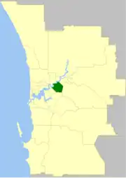 The City of Belmont within the Perth Metropolitan Area | |||||||||||||||
| Population | 42,257 (LGA 2021)[1] | ||||||||||||||
| Established | 1898 | ||||||||||||||
| Area | 39.8 km2 (15.4 sq mi) | ||||||||||||||
| Mayor | Robert Rossi[2] | ||||||||||||||
| Council seat | Belmont | ||||||||||||||
| Region | Eastern Metropolitan Perth | ||||||||||||||
| State electorate(s) | Belmont | ||||||||||||||
| Federal division(s) | Swan | ||||||||||||||
| Website | City of Belmont | ||||||||||||||
| |||||||||||||||
Belmont contains Perth's domestic and international airports which account for 33.7% of the City of Belmont's land area.
History
The Belmont Road District was created on 2 December 1898. On 4 October 1907, it was renamed Belmont Park. From 1906 until 1909, Burswood Island was part of the district.
On 1 July 1961, the Belmont Park Road District became the Shire of Belmont following the enactment of the Local Government Act 1960. On 17 February 1979 it attained city status.[3][4]
Ascot and Belmont are suburbs long associated with horses, being close to the race tracks (see Ascot Racecourse and Belmont Park). Until 1956 the Belmont Spur Railway linked Bayswater on the Perth to Midland line to the Ascot race track.
Wards
The city is divided into three wards: East Ward, West Ward and South Ward. Each ward has three councillors. The Mayor and Deputy Mayor are elected from among the councillors. Elections are held on the third Saturday in October every odd year, with councillors elected to four year terms. Approximately half of all positions are up for election at each election.[5][6]
Political parties do not typically endorse candidates in local government in Western Australia. However, elected members are required to disclose membership of any political party.[7]
| Ward[5] | Councillor | Joined council[5] | Term ends[5] | Notes[5][7] |
|---|---|---|---|---|
| East | Phillip Marks | 1999 | 2023 | Mayor |
| Margie Bass | 2011 | 2023 | Previously councillor from 1996 to 2007 | |
| Bernie Ryan | 2013 | 2025 | ||
| West | Robert Rossi | 2003 | 2023 | Became Deputy Mayor in 2021, having previously been in the role from 2013 to 2019 |
| Deborah Sessions | 2021 | 2025 | ||
| George Sekulla | 2017 | 2025 | Served as Deputy Mayor from 2019 to 2021
Justice of the Peace | |
| South | Jenny Davis | 2017 | 2025 | Member of the Australian Labor Party |
| Natalie Carter | 2021 | 2025 | ||
| Steve Wolff | 2007 | 2023 |
Suburbs
The suburbs of the City of Belmont with population and size figures based on the most recent Australian census:[8][9]
| Suburb | Population | Area | Map |
|---|---|---|---|
| Ascot | 3,095 (SAL 2021)[10] | 3.6 km2 (1.4 sq mi) | |
| Belmont | 6,959 (SAL 2021)[11] | 4.4 km2 (1.7 sq mi) | |
| Cloverdale | 8,864 (SAL 2021)[12] | 3.9 km2 (1.5 sq mi) | |
| Kewdale | 7,397 (SAL 2021)[13] | 8.4 km2 (3.2 sq mi) | |
| Perth Airport * | 25 (SAL 2021)[14] | 19.2 km2 (7.4 sq mi) | |
| Redcliffe | 5,030 (SAL 2021)[15] | 2.7 km2 (1.0 sq mi) | |
| Rivervale | 10,897 (SAL 2021)[16] | 3.3 km2 (1.3 sq mi) |
( * indicates suburb partially located within City)
Population
|
|
Mayors
Heritage-listed places
As of 2023, 110 places are heritage-listed in the City of Belmont,[18] of which seven are on the State Register of Heritage Places, among them the Garratt Road Bridge.[19]
References
- Australian Bureau of Statistics (28 June 2022). "Belmont (Local Government Area)". Australian Census 2021 QuickStats. Retrieved 28 June 2022.
- Dietsch, Jake (23 October 2023). "Local elections: Geraldton Mayor out for the count but Liberal candidate wins a spot in Rockingham". The West Australian. Retrieved 24 October 2023.
- WA Electoral Commission, Municipality Boundary Amendments Register (release 3.0), 31 July 2007.
- "Local Government Act 1960-1978 - Order in Council (per LG. BL-1-10)". Western Australia Government Gazette. 22 December 1978. p. 1978:4778.
- "Meet your Mayor and Councillors". CIty of Belmont. Retrieved 10 January 2022.
- "Elections". City of Belmont. Retrieved 10 January 2022.
- "Elected Members' Contact Details and Memberships Register" (PDF). City of Belmont. Retrieved 10 January 2022.
- "SLIP Map". maps.slip.wa.gov.au. Landgate. Retrieved 1 January 2023.
- "NationalMap". nationalmap.gov.au. Geoscience Australia. Retrieved 1 January 2023.
- Australian Bureau of Statistics (28 June 2022). "Ascot (WA) (Suburb and Locality)". Australian Census 2021 QuickStats. Retrieved 28 June 2022.
- Australian Bureau of Statistics (28 June 2022). "Belmont (WA) (Suburb and Locality)". Australian Census 2021 QuickStats. Retrieved 28 June 2022.
- Australian Bureau of Statistics (28 June 2022). "Cloverdale (Suburb and Locality)". Australian Census 2021 QuickStats. Retrieved 28 June 2022.
- Australian Bureau of Statistics (28 June 2022). "Kewdale (Suburb and Locality)". Australian Census 2021 QuickStats. Retrieved 28 June 2022.
- Australian Bureau of Statistics (28 June 2022). "Perth Airport (Suburb and Locality)". Australian Census 2021 QuickStats. Retrieved 28 June 2022.
- Australian Bureau of Statistics (28 June 2022). "Redcliffe (WA) (Suburb and Locality)". Australian Census 2021 QuickStats. Retrieved 28 June 2022.
- Australian Bureau of Statistics (28 June 2022). "Rivervale (Suburb and Locality)". Australian Census 2021 QuickStats. Retrieved 28 June 2022.
- "Welcome to the Adachi Belmont Sister City Web Site". Archived from the original on 10 October 2008. Retrieved 22 October 2009.
- "City of Belmont Heritage Places". inherit.stateheritage.wa.gov.au. Heritage Council of Western Australia. Retrieved 16 February 2023.
- "City of Belmont State Register of Heritage Places". inherit.stateheritage.wa.gov.au. Heritage Council of Western Australia. Retrieved 16 February 2023.