Bergen Street station (IRT Eastern Parkway Line)
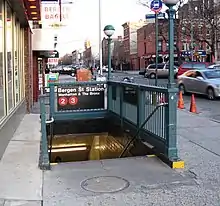
The Bergen Street station is a local station on the IRT Eastern Parkway Line of the New York City Subway, located at Bergen Street and Flatbush Avenue in Park Slope, Brooklyn. It is served by the 2 train at all times, the 3 train at all times except late nights, and the 4 train during late nights.
Bergen Street | ||||||||||||||||||||||||||||||||||||||||||||||||||||||||||||||||||||
|---|---|---|---|---|---|---|---|---|---|---|---|---|---|---|---|---|---|---|---|---|---|---|---|---|---|---|---|---|---|---|---|---|---|---|---|---|---|---|---|---|---|---|---|---|---|---|---|---|---|---|---|---|---|---|---|---|---|---|---|---|---|---|---|---|---|---|---|---|
 Northbound platform | ||||||||||||||||||||||||||||||||||||||||||||||||||||||||||||||||||||
| Station statistics | ||||||||||||||||||||||||||||||||||||||||||||||||||||||||||||||||||||
| Address | Bergen Street & Flatbush Avenue Brooklyn, NY 11217 | |||||||||||||||||||||||||||||||||||||||||||||||||||||||||||||||||||
| Borough | Brooklyn | |||||||||||||||||||||||||||||||||||||||||||||||||||||||||||||||||||
| Locale | Park Slope | |||||||||||||||||||||||||||||||||||||||||||||||||||||||||||||||||||
| Coordinates | 40.680833°N 73.97511°W | |||||||||||||||||||||||||||||||||||||||||||||||||||||||||||||||||||
| Division | A (IRT)[1] | |||||||||||||||||||||||||||||||||||||||||||||||||||||||||||||||||||
| Line | IRT Eastern Parkway Line | |||||||||||||||||||||||||||||||||||||||||||||||||||||||||||||||||||
| Services | 2 3 4 | |||||||||||||||||||||||||||||||||||||||||||||||||||||||||||||||||||
| Transit | ||||||||||||||||||||||||||||||||||||||||||||||||||||||||||||||||||||
| Structure | Underground | |||||||||||||||||||||||||||||||||||||||||||||||||||||||||||||||||||
| Platforms | 2 side platforms | |||||||||||||||||||||||||||||||||||||||||||||||||||||||||||||||||||
| Tracks | 6 | |||||||||||||||||||||||||||||||||||||||||||||||||||||||||||||||||||
| Other information | ||||||||||||||||||||||||||||||||||||||||||||||||||||||||||||||||||||
| Opened | October 10, 1920 | |||||||||||||||||||||||||||||||||||||||||||||||||||||||||||||||||||
| Opposite- direction transfer | No | |||||||||||||||||||||||||||||||||||||||||||||||||||||||||||||||||||
| Traffic | ||||||||||||||||||||||||||||||||||||||||||||||||||||||||||||||||||||
| 2019 | 1,208,319[2] | |||||||||||||||||||||||||||||||||||||||||||||||||||||||||||||||||||
| Rank | 330 out of 424[2] | |||||||||||||||||||||||||||||||||||||||||||||||||||||||||||||||||||
| ||||||||||||||||||||||||||||||||||||||||||||||||||||||||||||||||||||
| ||||||||||||||||||||||||||||||||||||||||||||||||||||||||||||||||||||
| ||||||||||||||||||||||||||||||||||||||||||||||||||||||||||||||||||||
| ||||||||||||||||||||||||||||||||||||||||||||||||||||||||||||||||||||
| ||||||||||||||||||||||||||||||||||||||||||||||||||||||||||||||||||||
History
After the Interborough Rapid Transit Company (IRT)'s original line opened as far as Atlantic Avenue in Brooklyn, the New York City government began planning new lines. As early as 1903, William Barclay Parsons, chief engineer of the Rapid Transit Commission, had proposed constructing a four-track extension of the IRT line under Flatbush Avenue, running southeast from Atlantic Avenue to Grand Army Plaza. From there, two branches would have extended south to Flatbush and east to Brownsville. This plan did not progress for a decade due to various disputes over the original subway.[3]: 150 In 1913, New York City, the Brooklyn Rapid Transit Company (BRT), and the IRT reached an agreement, known as the Dual Contracts, to drastically expand subway service across New York City.[4] As part of the Dual Contracts, two lines under Flatbush Avenue, one each operated by the BRT and IRT, were approved.[5]: 203–219 [4] The IRT was authorized to extend its four-track Brooklyn line under Flatbush Avenue and Eastern Parkway,[6] while the BRT would construct a parallel two-track extension of the Brighton Line,[7]
Groundbreaking for the IRT extension took place on May 23, 1914.[8][9] The Bergen Street station was to be one of the stations on the IRT extension.[9]
Service on the IRT Eastern Parkway Line had been extended from Atlantic Avenue to Utica Avenue in August 1920,[10] but the Bergen Street, Grand Army Plaza, and Eastern Parkway–Brooklyn Museum stations were not ready to open with the rest of the line.[11][12] The contractor responsible for completing the three stations had gone bankrupt in the middle of the project.[12] The stations opened on October 9, 1920.[11][13] The BMT Brighton Line was already in use at the time but used trackage that is now part of the Franklin Avenue Shuttle; the opening of the subway line beneath Flatbush Avenue provided a more direct route to Downtown Brooklyn and, eventually, Manhattan.[13]
During the 1964–1965 fiscal year, the platforms at Bergen Street, along with those at four other stations on the Eastern Parkway Line, were lengthened to 525 feet (160 m) to accommodate a ten-car train of 51 foot (16 m) IRT cars.[14][15] The work was performed by the Arthur A. Johnson Corporation.[15]
Station layout
| Ground | Street level | Exit/entrance |
| Basement 1 | Side platform | |
| Northbound local | ← ← ← | |
| Curtain wall | ||
| Northbound express | ← | |
| Brighton Line | ← | |
| | ||
| Southbound express | | |
| Curtain wall | ||
| Southbound local | | |
| Side platform | ||

The station contains six tracks and two side platforms: the outermost tracks are used by the IRT local trains. To the inside are the IRT express tracks, which slant upward to the inside of the outer local tracks. In between the express tracks are the BMT Brighton Line tracks. Those routes were built at the same time as the tracks at this station as part of the Dual Contracts. A full curtain wall separates the local from the express tracks, though a gap exists in the curtain wall at the end of the station.
The 2 train stops here at all times,[16] while the 3 train stops here at all times except late nights.[17] The 4 train serves the station only during late nights.[18] The next station to the north is Atlantic Avenue–Barclays Center, while the next station to the south is Grand Army Plaza.[19]
Both platforms have their original mosaics. The name tablets read "BERGEN ST." in gold serif font on a blue background and multi-layered green border. The trim line is green with "B" tablets on them on a blue background at regular intervals. At either ends of both platforms, where they were extended in 1964–1965,[14] there are cinderblock tiles with signs reading "BERGEN ST" in sans serif font on a maroon background.
The platforms only have columns at the fare control areas and they are i-beam columns painted green.
Exits
Each platform has one same-level fare control area at the center and there are no crossovers or crossunders. The southbound platform has an unstaffed fare control area containing a bank of three regular turnstiles, two exit-only turnstiles, and two High Entry/Exit Turnstiles. Outside fare control are two staircases going up to the southwestern corner of Flatbush Avenue and Bergen Street and a passage leading to another staircase going up to the northwestern corner.[20] The Manhattan-bound platform has a full-time turnstile bank and token booth. Outside fare control are and two staircases going up to either eastern corners of Bergen Street and Flatbush Avenue, as well as a closed and sealed stair to the southwestern corner of Sixth Avenue and Bergen Street.
References
- "Glossary". Second Avenue Subway Supplemental Draft Environmental Impact Statement (SDEIS) (PDF). Vol. 1. Metropolitan Transportation Authority. March 4, 2003. pp. 1–2. Archived from the original (PDF) on February 26, 2021. Retrieved January 1, 2021.
- "Facts and Figures: Annual Subway Ridership 2014–2019". Metropolitan Transportation Authority. 2020. Retrieved May 26, 2020.
- Hood, Clifton (1978). "The Impact of the IRT in New York City" (PDF). Historic American Engineering Record. pp. 146–207 (PDF pp. 147–208). Archived (PDF) from the original on January 17, 2021. Retrieved December 20, 2020.
 This article incorporates text from this source, which is in the public domain.
{{cite web}}: CS1 maint: postscript (link) - "Subway Contracts Solemnly Signed; Cheers at the Ceremonial Function When McCall Gets Willcox to Attest" (PDF). The New York Times. March 20, 1913. ISSN 0362-4331. Archived (PDF) from the original on May 4, 2022. Retrieved January 11, 2018.
- Walker, James Blaine (1918). Fifty Years of Rapid Transit — 1864 to 1917. New York, N.Y.: Law Printing. Retrieved November 6, 2016.
- "Subway Contracts Solemnly Signed; Cheers at the Ceremonial Function When McCall Gets Willcox to Attest" (PDF). The New York Times. March 20, 1913. ISSN 0362-4331. Archived (PDF) from the original on May 4, 2022. Retrieved January 11, 2018.
- "Transit Relief Big Stimulus". The Brooklyn Citizen. April 13, 1913. pp. 13, 14. Archived from the original on May 22, 2023. Retrieved May 21, 2023 – via newspapers.com.
- "Subway Festival Held in Brooklyn; McCall Turns the First Sod for Interborough Extension from Atlantic Ave". The New York Times. May 24, 1914. ISSN 0362-4331. Archived from the original on November 3, 2020. Retrieved May 20, 2023.
- "Line Begun Today Taps Big Section". The Brooklyn Daily Eagle. May 23, 1914. p. 23. Retrieved July 6, 2023.
- "More Interborough Service for Brooklyn 2 New Lines". pudl.princeton.edu. Interborough Rapid Transit Company. August 23, 1920. Retrieved September 19, 2016.
- "Subway Stations Opened: Last Three in Eastern Parkway Branch of I.R.T. Put Into Service" (PDF). New York Times. October 11, 1920. Retrieved December 20, 2015.
- "3 New Subway Stations Open". Times Union. October 10, 1920. p. 1. Retrieved July 6, 2023.
- "IRT Brooklyn Line Opened 90 Years Ago". New York Division Bulletin. New York Division, Electric Railroaders' Association. 53 (9). September 2010. Retrieved August 31, 2016 – via Issuu.
- Annual Report 1964–1965. New York City Transit Authority. 1965.
- New York City Transit Authority (1964). Proceedings of the New York City Transit Authority Relating to Matters Other Than Operation. The Authority. p. 86.
- "2 Subway Timetable, Effective June 26, 2022". Metropolitan Transportation Authority. Retrieved August 26, 2023.
- "3 Subway Timetable, Effective June 26, 2022". Metropolitan Transportation Authority. Retrieved August 26, 2023.
- "4 Subway Timetable, Effective December 4, 2022". Metropolitan Transportation Authority. Retrieved August 26, 2023.
- "Subway Map" (PDF). Metropolitan Transportation Authority. September 2021. Retrieved September 17, 2021.
- "MTA Neighborhood Maps: Park Slope/Prospect Park" (PDF). mta.info. Metropolitan Transportation Authority. 2015. Retrieved August 2, 2015.
External links
- nycsubway.org
- Brooklyn IRT: Bergen Street (text used with permission)
- Brooklyn IRT: Map 2, Brooklyn IRT Dual Contracts (includes current and former track configurations, and provisions for future connections)


