Römerberg
Römerberg is a municipality in the Rhein-Pfalz-Kreis, in Rhineland-Palatinate, Germany. It is situated on the left bank of the Rhine, approximately 5 kilometres (3.1 mi) southwest of Speyer.
Römerberg | |
|---|---|
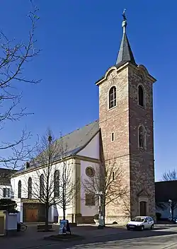 Church of Saint Sigismund in Heiligenstein | |
 Coat of arms | |
Location of Römerberg within Rhein-Pfalz-Kreis district 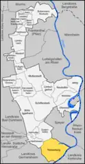 | |
 Römerberg  Römerberg | |
| Coordinates: 49°17′14″N 8°23′52″E | |
| Country | Germany |
| State | Rhineland-Palatinate |
| District | Rhein-Pfalz-Kreis |
| Municipal assoc. | Römerberg-Dudenhofen |
| Subdivisions | 3 |
| Government | |
| • Mayor (2019–24) | Matthias Hoffmann[1] (Greens) |
| Area | |
| • Total | 27.86 km2 (10.76 sq mi) |
| Elevation | 108 m (354 ft) |
| Population (2021-12-31)[2] | |
| • Total | 9,865 |
| • Density | 350/km2 (920/sq mi) |
| Time zone | UTC+01:00 (CET) |
| • Summer (DST) | UTC+02:00 (CEST) |
| Postal codes | 67354 |
| Dialling codes | 06232 |
| Vehicle registration | RP |
| Website | www.roemerberg.de |
History
The municipality of Römerberg was established by the fusion of the municipalities of Berghausen, Heiligenstein and Mechtersheim in 1969. The seat of the municipality is in the village Heiligenstein.
References
- Direktwahlen 2019, Rhein-Pfalz-Kreis, Landeswahlleiter Rheinland-Pfalz, accessed 4 August 2021.
- "Bevölkerungsstand 2021, Kreise, Gemeinden, Verbandsgemeinden" (in German). Statistisches Landesamt Rheinland-Pfalz. 2022.
This article is issued from Wikipedia. The text is licensed under Creative Commons - Attribution - Sharealike. Additional terms may apply for the media files.