Bitou Cape
The Bitou Cape (traditional Chinese: 鼻頭角; simplified Chinese: 鼻头角; pinyin: Bítóu Jiǎo) is a cape in Ruifang District, New Taipei, Taiwan.
Bitou Cape
鼻頭角 | |
|---|---|
 | |
 Bitou Cape Taiwan | |
| Coordinates: 25°07′41.6″N 121°55′23.3″E | |
| Location | Ruifang, New Taipei, Taiwan |
| Geology | cape |
Name
The name Bitou means the tip of the nose in Chinese language.[1]
Geology
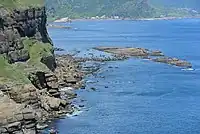
The cape is the northeasternmost cape of Taiwan. It is the sea-eroded type of land form, thus it includes several features such as sea cliffs, undercut bluffs and platforms.[2]
Architecture
The cape is equipped with a circular route of walking trail, which starts from Bitou Fishing Port and ends up at Bitou Elementary School. It also houses a military barrack and the Bitoujiao Lighthouse at the end of the cape.[3]
Transportation
The cape is accessible by bus from Taipei Main Station.[2]
See also
References
- "Bitou Cape Park". roundTAIWANround. Retrieved 11 November 2019.
- "Bitou Cape". Taiwan, the Heart of Asia. 7 October 2020. Retrieved 20 September 2022.
- Liao, George (10 September 2017). "Bitou Cape Trail on Taiwan's Northeast Coast offers stunning views". Taiwan News. Retrieved 11 November 2019.
Wikimedia Commons has media related to Bitou Cape.
This article is issued from Wikipedia. The text is licensed under Creative Commons - Attribution - Sharealike. Additional terms may apply for the media files.