Bowdoin Street
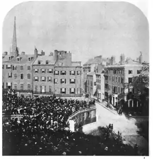
Bowdoin Street in Boston, Massachusetts extends from the top of Beacon Street, down Beacon Hill to Cambridge Street, near the West End. It was originally called "Middlecott Street" as early as the 1750s.[1] In 1805[2] it was renamed after the Governor James Bowdoin.
Location and description

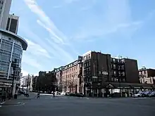
Bowdoin is situated on the north side of Beacon Hill, and runs north to south. It is primarily a residential street. Topographically, Bowdoin Street is a hill from Cambridge Street at the bottom to its north, and Beacon Street at the top to its south.
Residences
The street is flanked on both sides by apartment complexes. Lindsay Place dominates the western side, with four buildings built in 1886 which are protected historic buildings. Bowdoin Place, completed in 2003, extends along the street's eastern half.
In the 18th century Governor James Bowdoin lived at the corner of Beacon and Bowdoin Streets. He had "one of the largest gardens of that day [in Boston], ... a large house and an extensive lot of land. ... He had a garden abounding in the finest fruits—pears and peaches, apples and grapes."[3] At the turn of the 19th century, Joseph Coolidge, Sr., lived here in a large house built by architect Charles Bulfinch. Bulfinch himself lived on Bowdoin Street, briefly.[4] From 1946 to his death, John F. Kennedy kept an apartment at 122 Bowdoin Street.[5]

Government buildings
The Massachusetts State House faces Beacon Street with several entrances from Bowdoin Street. Ashburton Place, which contains other state and local offices, is also accessible from Bowdoin.
Businesses
The few businesses on Bowdoin are restaurants, including Grotto (between 33 and 45 Bowdoin) and the Dunkin' Donuts at the corner. Duck-Boat operators' patter refers to the coffee shop as "the only place in town where you can get a cappuccino and sushi at once." The Osaka Sushi place shares the building with the doughnut shop and a deli.
There are two bars on the street. At the north end, the Red Hat, known for its pitchers of Mud Slides and other frozen drinks, is referred to as "Old Scollay's Red Hat." The other bar, at the south end, is the "Twenty-First Amendment," named for the Constitutional amendment to repeal alcohol prohibition in the United States.

Church
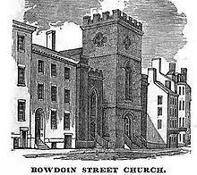
St. John the Evangelist Episcopal Church is on Bowdoin Street. Solomon Willard designed it.[6] "The church building, made of stone in a gothic style, was erected in 1831 by Congregationalist Christians. From 1863–83, it was occupied by the Church of the Advent (which afterwards moved to its current location on Brimmer Street). In 1883, the building became the Mission Church of St. John the Evangelist under the auspices of the Society of St. John the Evangelist, a monastic order. After building a new monastery on Memorial Drive in Cambridge, the SSJE brothers continued their mission work at St. John's. In 1985, almost a century after the brothers established the mission church here, St. John's became a Parish Church in the Episcopal Diocese of Massachusetts."[7]
The Square
Bowdoin Square was put to rest in about 1955, but lives on as a subway station, called appropriately, "Bowdoin." It is at one end of the Blue Line of the MBTA.
Gallery
 Beacon Hill, with Mr. Thurston's house, from Bowdoin Street, ca.1811
 Advertisement for furniture auction, 1816
 Order of services for the Fatherless and Widows' Society, Bowdoin Street Meeting House, 1834
 Mr. & Mrs. Wilkes' establishment for young ladies, 1845
 Corner of Cambridge St. and Bowdoin St., 2010
 Leverett Saltonstall Place, off of Bowdoin St., 2010
 Bowdoin Street Church in 2023
References
- Middlecott's four-acre pasture. Gleaner, 1855; In: City of Boston. 5th report of the Record Commissioners, 1880, rev. ed. Boston: 1887.
- Boston Street Laying-Out Dept. A record of the streets, alleys, places, etc. in the city of Boston. Boston: City Printing Dept., 1910.
- Winsor. Memorial History of Boston, v.4. 1886; p.612.
- Ellen Susan Bulfinch. Life and Letters of Charles Bulfinch, Architect. Houghton, Mifflin & Co., Boston and New York, 1896; p.127, 140.
- Jerry Morris. Boston Globe Guide to Boston, 7th ed. 2005; p.82
- "Attributed to Solomon Willard." Cf. Douglass Shand-Tucci. Built in Boston: city and suburb, 1800-2000, 2nd ed. Univ of Massachusetts Press, 1999; p.17.
- "Information | The Church of Saint John the Evangelist". stjev.org. Archived from the original on 2008-08-20.
External links
- Bostonian Society Archived 2010-05-09 at the Wayback Machine has materials related to the street.
- Google news archive.
- https://www.loc.gov/pictures/item/2003654251/
- https://www.loc.gov/pictures/item/95860749/
