Brûlée River (Champlain River tributary)
The Brûlée River (Champlain River tributary) is flowing entirely in the municipality of Saint-Maurice, in the Les Chenaux Regional County Municipality, in the administrative region of Mauricie, in Quebec, Canada.
| Brulée River | |
|---|---|
 Rang Saint-Alexis, Saint-Maurice | |
 | |
| Native name | Rivière Brulée (French) |
| Location | |
| Country | |
| Province | |
| Region | Mauricie |
| Physical characteristics | |
| Source | Massicotte Lake |
| • location | Saint-Maurice, Les Chenaux Regional County Municipality, Mauricie administrative region, Quebec, Canada |
| • coordinates | 46°30′01″N 72°35′30″W |
| • elevation | 103 m (338 ft) |
| Mouth | Champlain River |
• location | Saint-Maurice, Les Chenaux Regional County Municipality |
• coordinates | 46°26′51″N 72°30′02″W |
• elevation | 29 m (95 ft) |
| Length | 14.1 km (8.8 mi) |
| Basin features | |
| Tributaries | |
| • left | Discharge of lac Lacommande. |
| • right | Ruisseau Morin |
The course of the Brûlée river flows on the east side of the Saint-Maurice River and on the north side of the St. Lawrence River. This river is part of the hydrographic side of the Champlain River which generally winds north-east, then south-east, to the north shore of the St. Lawrence River.
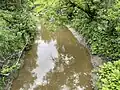
With the exception of a short forest area at the start and end of its course, the Brûlée River descends mainly in agricultural areas.
Toponymy
The term "burned" is used to identify a certain number of realities, often related to fire, to a fire started either by nature (lightning or other) or by the hand of man, consequence of an accident, negligence or a deliberate, voluntary act.
The flames ravaged, destroying trees sometimes for weeks, spreading to nearby forests. At the same time, the "burned" created a large tract of fertile land, at least during the first years of its exploitation.
Sources : Rivière Brûlée (Burnt River) origin and meaning (fr)[1] - Rivière brûlée, Government of Canada, Geographical Name [2]
Geography
The Brûlée river rises at the mouth of Lac Massicotte (altitude: 102 metres (335 ft)). This small body of water is located south of Plé de Saint-Narcisse, on the north side of the hamlet Lac-Montreuil. The small lake is located 4.8 kilometres (3.0 mi) North-east of the center of the village of Notre-Dame-du-Mont-Carmel, 8.9 kilometres (5.5 mi) to the North -West of the confluence of the Brule river and 14.3 kilometres (8.9 mi) North-West of the North shore of the St. Lawrence River.
Photos
Rivière Brûlée (Champlain River)
In Quebec, panel on bridges identifies watercourse, municipality, public road
- Saint-Maurice (parish municipality)
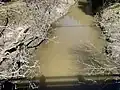 Rang Saint-Alexis, Bridge P-01571, rang Saint-Alexis
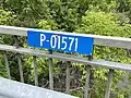 P-01571,[3] bridge's number, Rang Saint-Alexis
- Rang Saint-Alexis
 Rang Saint-Alexis
See also
- Les Chenaux Regional County Municipality
- Saint-Maurice, a municipality
- Champlain River, a stream
- St. Lawrence River, one of the great river on Earth
- List of rivers of Quebec
References
- "Rivière Brûlée, origin and meaning". Commission de toponymie Quebec (in French). Government of Quebec. Retrieved 23 June 2023.
- "Rivière brûlée, Search the Canadian Geographical Names Databas". Geographical Names Board of Canada. Government of Canada. Retrieved 23 June 2023.
- "P-01571, bridge". Ministère des Transports et de la Mobilité durable. Quebec Government. Retrieved 23 June 2023.