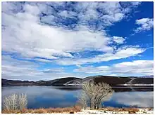
Bridgeport Reservoir
Bridgeport Reservoir is a lake at the lower end of Bridgeport Valley in Mono County, California. Its earth-filled dam was constructed in 1923 by the Walker River Irrigation District,[3] along the East Walker River. The lake has a storage capacity of 42,455 acre-feet (52,367,000 m3)[4] and is regulated by a Federal Watermaster supplying primarily agricultural irrigation and flood control for Lyon County, Nevada.[5]
| Bridgeport Reservoir | |
|---|---|
 Roadside view of Bridgeport Reservoir | |
 Bridgeport Reservoir  Bridgeport Reservoir | |
| Location | Mono County, California |
| Coordinates | 38°17′20″N 119°13′52″W[1] |
| Type | reservoir[1] |
| Primary inflows | East Walker River |
| Primary outflows | East Walker River[1][2] |
| Catchment area | 356 square miles (920 km2)[2] |
| Basin countries | United States |
| Managing agency | Walker River Irrigation District |
| Built | 1924[2] |
| Surface area | 3,125 acres (1,265 ha)[2] |
| Water volume | 44,100 acre-feet (54,400,000 m3)[2] |
| Surface elevation | 6,460 feet (1,970 m)[1] |
| Settlements | Bridgeport, California |
| Bridgeport Dam | |
|---|---|
 | |
 Location of Bridgeport Dam in California | |
| Country | United States |
| Location | Mono County, California |
| Coordinates | 38°17′20″N 119°13′52″W |
| Owner(s) | Walker River Irrigation District[2] |
| Dam and spillways | |
| Type of dam | Earth[2] |
| Impounds | East Walker River[2] |
| Height | 63 feet (19 m)[2] |
| Length | 900 feet (270 m)[2] |
| Elevation at crest | 6,471 feet (1,972 m)[2] |
| Width (crest) | 15 feet (4.6 m)[2] |
| Dam volume | 132,000 cubic yards (101,000 m3)[2] |
| Reservoir | |
| Creates | Bridgeport Reservoir |
| Total capacity | 44,100 acre-feet (54,400,000 m3)[2] |
| Catchment area | 356 square miles (920 km2)[2] |
| Surface area | 3,125 acres (1,265 ha)[2] |
| Normal elevation | 6,460 feet (1,970 m)[1] |
The community of Bridgeport, which is the seat of Mono County, and the Bryant Field airstrip, are located along the river and adjacent to the upper end of the lake.
Recreational opportunities include boating and trout fishing, and resorts with boat launch facilities are located along the lake's eastern shore.[6] Access is provided by California State Route 182.
References
- "Bridgeport Reservoir". Geographic Names Information System. United States Geological Survey, United States Department of the Interior.
- "Dams Within the Jurisdiction of the State of California (A-G)" (PDF). California Department of Water Resources. Archived from the original (PDF) on March 9, 2012. Retrieved October 4, 2012.
- State of Nevada Division of Water Resources, "Walker River Chronology" Archived December 19, 2009, at the Wayback Machine
- University of Nevada, Reno Cooperative Extension, Fact Sheet 98-18, "Recreational Activities and Issues in the Walker River Basin" Archived December 19, 2009, at the Wayback Machine
- Western Engineering and Surveying Services, "History of Water Right Transfers in Walker River Basin", Prepared for Great Basin Land and Water, April 23, 2007 Archived June 7, 2010, at the Wayback Machine accessed December 2009
- California Department of Boating and Waterways, Facility Index, ID number 293 Archived 2010-01-12 at the Wayback Machine accessed December 2009