Brumunda
Brumunda is a river in Innlandet county, Norway. The 32.2-kilometre (20.0 mi) long river begins at the lake Brumundsjøen on the border of Ringsaker and Hamar municipalities. The river begins at the lake, just north of Høljemyra and continues in a southerly direction to the south of Bersbuseter. The river ends at Brumunddal where it flows into the lake Mjøsa a few kilometres north of the town of Hamar.[1]
| Brumunda | |
|---|---|
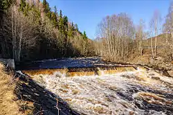 View of the river Brumunda north of Brumunddal | |
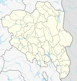 Location of the river  Brumunda (Norway) | |
| Location | |
| Country | Norway |
| County | Innlandet |
| Municipalities | Ringsaker Municipality |
| Physical characteristics | |
| Source | Brumundsjøen lake |
| • location | Ringsaker, Norway |
| • coordinates | 61.026557°N 11.10168°E |
| • elevation | 633 metres (2,077 ft) |
| Mouth | Mjøsa lake |
• location | Brumunddal, Norway |
• coordinates | 60.87620°N 10.930935°E |
• elevation | 121 metres (397 ft) |
| Length | 32.2 km (20.0 mi) |
| Basin size | 223.23 km2 (86.19 sq mi) |
| Discharge | |
| • average | 3.35 m3/s (118 cu ft/s) |
Brumunda serves as the border between Furnes and Veldre, and during the Middle Ages, it was the border between southern and northern Hedemarken. It still serves as the border between the southern and northern variants of the Hedmarksk dialect. North of the river people use ei and øy, while on the south side they say e and ø.
See also
This article is issued from Wikipedia. The text is licensed under Creative Commons - Attribution - Sharealike. Additional terms may apply for the media files.