Bueng Phra
Bueng Phra (Thai: บึงพระ) is a subdistrict in the Mueang Phitsanulok District of Phitsanulok Province, Thailand. The area is urban and lowland area. In 2022, it had a population of 19,074 and 9,199 households.[1]
Bueng Phra
บึงพระ | |
|---|---|
|
Seal | |
| Country | Thailand |
| Province | Phitsanulok |
| District | Mueang Phitsanulok |
| Government | |
| • Type | Subdistrict Administrative Organization (SAO) |
| Area | |
| • Total | 34.2 km2 (13.2 sq mi) |
| Population (2022)[1] | |
| • Total | 19,074 |
| • Density | 557/km2 (1,440/sq mi) |
| Time zone | UTC+7 (ICT) |
| Postal code | 65000 |
| Calling code | 055 |
| Geocode | 65011800 |
| Website | www |
Geography
The topography of Bueng Phra subdistrict is fertile lowlands and is located in the lower northern part of Thailand. The subdistrict is bordered to the north by the city of Phitsanulok and Aranyik subdistrict, to the east by Wang Thong district , to the south by Wat Phrik subdistrict and to the west by Wat Chan subdistrict. Bueng Phra subdistrict lies in the Nan Basin, which is part of the Chao Phraya Watershed. The Nan river flows west of the subdistrict.[2]
History
The legend said that the boat carrying the Buddha image was wrecked. Therefore the villagers call that spot "Bueng Phra".[3]
Bueng Phra Subdistrict Administrative Organization was established, published 30 January 1996 in Royal Thai Government Gazette, General Issue, Volume 113, Section 9 Ngor.[4]
Administration
Central government
The administration of Bueng Phra subdistrict (tambon) is responsible for an area that covers 21,362 rai ~ 34.2 square kilometres (13.2 sq mi) and consists of ten administrative villages (muban), as of 2022: 19,074 people and 9,199 households.[5][1]
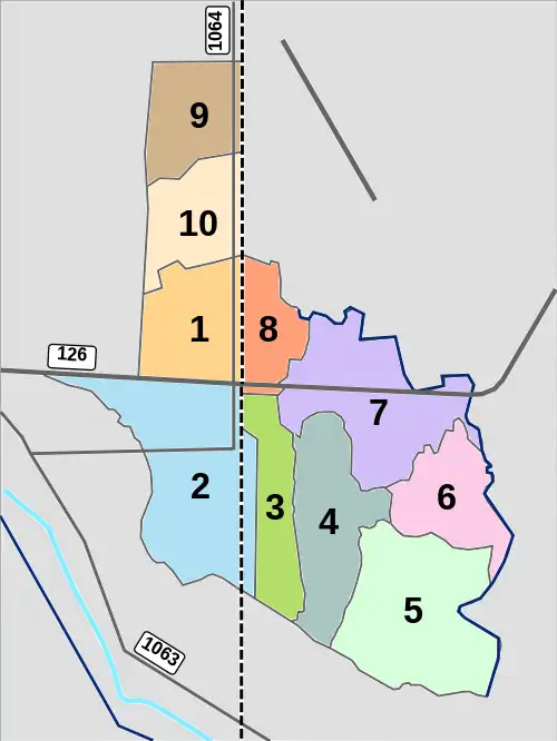
| Village | English | Thai | People | Households |
|---|---|---|---|---|
| Moo1 | Ban Na Pho Daeng | บ้านนาโพธิ์แดง | 2,128 | 1,358 |
| Moo2 | Ban Nong Tom Noi | บ้านหนองตมน้อย | 2,122 | 827 |
| Moo3 | Ban Bueng Phra | บ้านบึงพระ | 1,498 | 748 |
| Moo4 | Ban Pak Lat Mai | บ้านปากลาดใหม่ | 1,254 | 482 |
| Moo5 | Ban Khlong Chan | บ้านคลองจันทร์ | 677 | 289 |
| Moo6 | Ban Nong Phai Lom | บ้านหนองไผ่ล้อม | 1,001 | 664 |
| Moo7 | Ban Dong Phikun | บ้านดงพิกุล | 2,185 | 1,343 |
| Moo8 | Ban Saphan Sie | บ้านสะพานที่สิ่ | 2,180 | 1,044 |
| Moo9 | Ban Na Pho Daeng | บ้านนาโพธิ์แดง | 3,542 | 1,459 |
| Moo10 | Ban Na Thong Phatthana | บ้านนาทองพัฒนา | 1,722 | 984 |
Temples
Bueng Phra subdistrict is home to the following active temples, where Theravada Buddhism is practised by local residents:[6]
| Temple name | Thai | Location |
|---|---|---|
| Wat Bueng Phra | วัดบึงพระ | Moo2 |
| Wat Santiwan | วัดสันติวัน | Moo3 |
| Wat Sutha Wanaram | ลัดสุธาวนาราม | Moo4 |
| Wat Rat Sattharam | วัดราษฏร์ศรัทธาราม | Moo5 |
| Wat Nong Phai Lom | วัดหนองไผ่ว้อม | Moo6 |
| Wat Phikun Thong | ลัดพิกุลทอง | Moo7 |
| Wat Phikun Wararam | วัดพิกุลวราราม | Moo8 |
Economy
Because the area is plain lowland with sandy soil and sandy loamy soil, it is suitable for farming and horticulture (kale, bok choy, lettuce, etc.).[7]
Retail and trading are mainly located along Phitsanulok-Bueng Phra road (1064).
Education
- Bungphra Phitsanulok Commercial College - Moo1
- Wat Bueng Phra School - Moo2
- Wat Mai Rat Sattharam School - Moo5
Healthcare
There is Bueng Phra health-promoting hospital in Ban Bueng Phra - Moo3.[8]
Transport
Roads
- Highway 126 (Phitsanulok bypass road)
- National road 1064 (Phitsanulok-Bueng Phra)[9]
Freight rail transport
PTT Public Company Limited operates a crude oil depot adjacent to Bueng Phra railway station (Moo3). SRT runs several oil freight services from this railway station to Mae Nam railway station in Chong Nonsi Subdistrict, Yan Nawa District, Bangkok. In 2019, that was a total of 866,931 tonnes.[10]
Electricity
All households in Bueng Phra subdistrict have access to the electricity grid of Provincial Electricity Authority (PEA).[11]
References
- "Official statistics registration systems". Department of Provincial Administration. Retrieved 17 April 2023, year 2022 >village level >ExcelFile >no.65011801-65011810 >Excel line 70446-70457
{{cite web}}: CS1 maint: postscript (link) - "อาณาเบตติดต่อ" [contact territory] (in Thai). Retrieved 24 April 2023.
- "ประวัติคำบล" [subdistrict history] (in Thai). Retrieved 24 April 2023.
- "ประาัติหน่วยงาน" [agency history] (in Thai). Retrieved 24 April 2023.
- "เขตการปกครอง" [subdivision] (in Thai). Retrieved 24 April 2023.
- "list of temples". Retrieved 24 April 2023, > no.28614 - 28619
{{cite web}}: CS1 maint: postscript (link) - "สภาพภูประเทศ" [terrain] (in Thai). Retrieved 24 April 2023.
- "การสาธารณสุข" [public health] (in Thai). Retrieved 24 April 2023.
- "การคมนาคม" [transportation] (in Thai). Retrieved 24 April 2023.
- Phitsanulok Provincial Statistical Report 2562-2019: Statistics of Railway Freight:2019. Phitsanulok Provincial Statistical Office (Report). National Statistical Office (NSO). 2020. p. 145. ISSN 1905-8314.
- "ไฟฟ้าในตำบล" [electricity in subdistrict] (in Thai). Retrieved 24 April 2023.