Bukkhalo
Bukkhalo (Thai: บุคคโล, pronounced [bùk.kʰā.lōː]) is a khwaeng (sub-district) of Thon Buri District, Bangkok. Its name is also the name of surrounding area.
Bukkhalo
บุคคโล | |
|---|---|
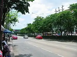 Ratchadaphisek Road in 2008 as seen from Dao Khanong, the opposite side is The Mall Tha Phra in Bukkhalo | |
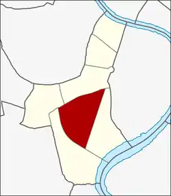 Location in Thon Buri District | |
| Country | Thailand |
| Province | Bangkok |
| Khet | Thon Buri |
| Area | |
| • Total | 1.210 km2 (0.467 sq mi) |
| Population (2019) | |
| • Total | 17,374 |
| • Density | 14,358.67/km2 (37,188.8/sq mi) |
| Postal code | 10600 |
| TIS 1099 | 101504 |
Geography
Bukkhalo is the central area of the district.
The area is bounded by other subdistricts (from north clockwise): Talat Phlu and Bang Yi Ruea in its district (Ratchaphruek Road is a divider line), Samre in its district (Somdet Phra Chao Tak Sin Road is a divider line), Dao Khanong in its district (Ratchadaphisek Road is a divider line), respectively.[2]
Places
- The Mall Tha Phra
- Wat Krachap Phinit
- Bukkhalo Intersection (shares with Samre and Dao Khanong)
- Wat Sutthawas
- Somdet Phra Pin Klao Hospital
- Pho Nimit BTS Station
Note: the local temple Wat Bang Nam Chon, indeed, it is located in the area of neighbouring Samre.[2]
References
- Administrative Strategy Division, Strategy and Evaluation Department, Bangkok Metropolitan Administration (2021). สถิติกรุงเทพมหานครประจำปี 2563 [Bangkok Statistics 2020] (PDF) (in Thai). Retrieved 27 November 2021.
{{cite web}}: CS1 maint: multiple names: authors list (link) - "แขวงบุคคโล เขตธนบุรี กรุงเทพมหานคร" [Bukkhalo Subdistrict, Thon Buri District, Bangkok]. Ro1.ldd.go.th (in Thai).
This article is issued from Wikipedia. The text is licensed under Creative Commons - Attribution - Sharealike. Additional terms may apply for the media files.